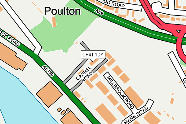
CH41 1DY lies on Cashel Road in Birkenhead. CH41 1DY is located in the Seacombe electoral ward, within the metropolitan district of Wirral and the English Parliamentary constituency of Wallasey. The Sub Integrated Care Board (ICB) Location is NHS Cheshire and Merseyside ICB - 12F and the police force is Merseyside. This postcode has been in use since June 1999.


GetTheData
Source: OS OpenMap – Local (Ordnance Survey)
Source: OS VectorMap District (Ordnance Survey)
Licence: Open Government Licence (requires attribution)
| Easting | 330697 |
| Northing | 390583 |
| Latitude | 53.407509 |
| Longitude | -3.043964 |
GetTheData
Source: Open Postcode Geo
Licence: Open Government Licence
| Street | Cashel Road |
| Town/City | Birkenhead |
| Country | England |
| Postcode District | CH41 |
| ➜ CH41 open data dashboard ➜ See where CH41 is on a map ➜ Where is Wallasey? | |
GetTheData
Source: Land Registry Price Paid Data
Licence: Open Government Licence
Elevation or altitude of CH41 1DY as distance above sea level:
| Metres | Feet | |
|---|---|---|
| Elevation | 10m | 33ft |
Elevation is measured from the approximate centre of the postcode, to the nearest point on an OS contour line from OS Terrain 50, which has contour spacing of ten vertical metres.
➜ How high above sea level am I? Find the elevation of your current position using your device's GPS.
GetTheData
Source: Open Postcode Elevation
Licence: Open Government Licence
| Ward | Seacombe |
| Constituency | Wallasey |
GetTheData
Source: ONS Postcode Database
Licence: Open Government Licence
| January 2024 | Violence and sexual offences | On or near Burnside Road | 281m |
| December 2023 | Violence and sexual offences | On or near Burnside Road | 281m |
| December 2023 | Public order | On or near Burnside Road | 281m |
| ➜ Cashel Road crime map and outcomes | |||
GetTheData
Source: data.police.uk
Licence: Open Government Licence
| Gorsedale Road (Gorsey Lane) | Poulton | 239m |
| Gorsedale Road (Gorsey Lane) | Poulton | 264m |
| Poulton Road (Gorsey Lane) | Poulton | 460m |
| Gorsey Lane (Dock Road) | Poulton | 461m |
| Mostyn Street (Poulton Road) | Poulton | 489m |
| Birkenhead North Station | 1km |
| Birkenhead Park Station | 1.2km |
| Conway Park Station | 2.1km |
GetTheData
Source: NaPTAN
Licence: Open Government Licence
GetTheData
Source: ONS Postcode Database
Licence: Open Government Licence


➜ Get more ratings from the Food Standards Agency
GetTheData
Source: Food Standards Agency
Licence: FSA terms & conditions
| Last Collection | |||
|---|---|---|---|
| Location | Mon-Fri | Sat | Distance |
| Buccleugh Street | 17:15 | 12:00 | 1,014m |
| Seacombe View | 17:33 | 12:00 | 1,397m |
| Ashville Road | 17:15 | 12:00 | 1,398m |
GetTheData
Source: Dracos
Licence: Creative Commons Attribution-ShareAlike
| Facility | Distance |
|---|---|
| Poulton Victoria Football Ground Clayton Lane, Poulton Grass Pitches | 268m |
| Oxton Park Poulton Road, Poulton Grass Pitches | 597m |
| Rycroft Playing Fields Rycroft Road, Poulton Grass Pitches | 743m |
GetTheData
Source: Active Places
Licence: Open Government Licence
| School | Phase of Education | Distance |
|---|---|---|
| Somerville Nursery School Brentwood Street, Wallasey, CH44 4BB | Nursery | 748m |
| Our Lady and St Edward's Catholic Primary School Price Street, Birkenhead, CH41 8DU | Primary | 837m |
| Kilgarth School Cavendish Street, Birkenhead, CH41 8BA | Not applicable | 837m |
GetTheData
Source: Edubase
Licence: Open Government Licence
The below table lists the International Territorial Level (ITL) codes (formerly Nomenclature of Territorial Units for Statistics (NUTS) codes) and Local Administrative Units (LAU) codes for CH41 1DY:
| ITL 1 Code | Name |
|---|---|
| TLD | North West (England) |
| ITL 2 Code | Name |
| TLD7 | Merseyside |
| ITL 3 Code | Name |
| TLD74 | Wirral |
| LAU 1 Code | Name |
| E08000015 | Wirral |
GetTheData
Source: ONS Postcode Directory
Licence: Open Government Licence
The below table lists the Census Output Area (OA), Lower Layer Super Output Area (LSOA), and Middle Layer Super Output Area (MSOA) for CH41 1DY:
| Code | Name | |
|---|---|---|
| OA | E00036855 | |
| LSOA | E01007270 | Wirral 010D |
| MSOA | E02001476 | Wirral 010 |
GetTheData
Source: ONS Postcode Directory
Licence: Open Government Licence
| CH44 4EG | Norwood Road | 180m |
| CH44 4EF | Norwood Road | 212m |
| CH44 4EQ | Norwood Road | 240m |
| CH44 4AQ | Gorsey Lane | 264m |
| CH44 4EL | Burnside Road | 269m |
| CH44 4EA | Mostyn Street | 284m |
| CH44 4AW | Gorsedale Road | 290m |
| CH44 4EE | Norwood Road | 304m |
| CH44 4AG | Gorsey Lane | 328m |
| CH44 4EP | Burnside Avenue | 331m |
GetTheData
Source: Open Postcode Geo; Land Registry Price Paid Data
Licence: Open Government Licence