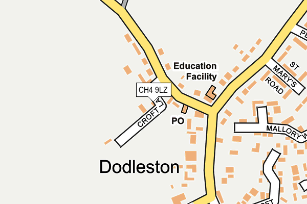
CH4 9LZ is located in the Christleton & Huntington electoral ward, within the unitary authority of Cheshire West and Chester and the English Parliamentary constituency of City of Chester. The Sub Integrated Care Board (ICB) Location is NHS Cheshire and Merseyside ICB - 27D and the police force is Cheshire. This postcode has been in use since January 1980.


GetTheData
Source: OS OpenMap – Local (Ordnance Survey)
Source: OS VectorMap District (Ordnance Survey)
Licence: Open Government Licence (requires attribution)
| Easting | 336037 |
| Northing | 361186 |
| Latitude | 53.143962 |
| Longitude | -2.957724 |
GetTheData
Source: Open Postcode Geo
Licence: Open Government Licence
| Country | England |
| Postcode District | CH4 |
| ➜ CH4 open data dashboard ➜ See where CH4 is on a map ➜ Where is Dodleston? | |
GetTheData
Source: Land Registry Price Paid Data
Licence: Open Government Licence
Elevation or altitude of CH4 9LZ as distance above sea level:
| Metres | Feet | |
|---|---|---|
| Elevation | 10m | 33ft |
Elevation is measured from the approximate centre of the postcode, to the nearest point on an OS contour line from OS Terrain 50, which has contour spacing of ten vertical metres.
➜ How high above sea level am I? Find the elevation of your current position using your device's GPS.
GetTheData
Source: Open Postcode Elevation
Licence: Open Government Licence
| Ward | Christleton & Huntington |
| Constituency | City Of Chester |
GetTheData
Source: ONS Postcode Database
Licence: Open Government Licence
| June 2022 | Violence and sexual offences | On or near St Mary'S Road | 267m |
| May 2022 | Criminal damage and arson | On or near Parking Area | 242m |
| May 2022 | Violence and sexual offences | On or near St Mary'S Road | 267m |
| ➜ Get more crime data in our Crime section | |||
GetTheData
Source: data.police.uk
Licence: Open Government Licence
| Primary School (Church Road) | Dodleston | 146m |
| Primary School (Church Road) | Dodleston | 156m |
| Penfold Way (Church Road) | Dodleston | 282m |
| Penfold Way (Church Road) | Dodleston | 292m |
| Welsh Road (Kinnerton Road) | Gorstella | 945m |
| Hawarden Station | 6.8km |
| Cefn-y-Bedd Station | 7km |
GetTheData
Source: NaPTAN
Licence: Open Government Licence
| Percentage of properties with Next Generation Access | 100.0% |
| Percentage of properties with Superfast Broadband | 100.0% |
| Percentage of properties with Ultrafast Broadband | 0.0% |
| Percentage of properties with Full Fibre Broadband | 0.0% |
Superfast Broadband is between 30Mbps and 300Mbps
Ultrafast Broadband is > 300Mbps
| Percentage of properties unable to receive 2Mbps | 0.0% |
| Percentage of properties unable to receive 5Mbps | 0.0% |
| Percentage of properties unable to receive 10Mbps | 0.0% |
| Percentage of properties unable to receive 30Mbps | 0.0% |
GetTheData
Source: Ofcom
Licence: Ofcom Terms of Use (requires attribution)
GetTheData
Source: ONS Postcode Database
Licence: Open Government Licence


➜ Get more ratings from the Food Standards Agency
GetTheData
Source: Food Standards Agency
Licence: FSA terms & conditions
| Last Collection | |||
|---|---|---|---|
| Location | Mon-Fri | Sat | Distance |
| Bell Meadow Business Park | 16:45 | 10:00 | 2,354m |
| Pulford (Old Post Office). | 16:15 | 09:45 | 2,768m |
| Rake Lane. | 16:15 | 07:00 | 2,827m |
GetTheData
Source: Dracos
Licence: Creative Commons Attribution-ShareAlike
| Facility | Distance |
|---|---|
| Dodleston Sports Field Dodleston, Chester Grass Pitches | 514m |
| Spa By Kasia Wrexham Road, Pulford, Caer Health and Fitness Gym, Swimming Pool, Outdoor Tennis Courts | 2.8km |
| King George V Playing Field (Pulford) Old Lane, Pulford, Chester Grass Pitches | 2.9km |
GetTheData
Source: Active Places
Licence: Open Government Licence
| School | Phase of Education | Distance |
|---|---|---|
| Dodleston CofE Primary School Church Road, Dodleston, Chester, CH4 9NG | Primary | 112m |
| Ysgol Derwen Higher Kinnerton, Flintshire, CH4 9AJ | Not applicable | 2.9km |
| Darland High School Chester Road, Rossett, LL12 0DL | Not applicable | 3.7km |
GetTheData
Source: Edubase
Licence: Open Government Licence
The below table lists the International Territorial Level (ITL) codes (formerly Nomenclature of Territorial Units for Statistics (NUTS) codes) and Local Administrative Units (LAU) codes for CH4 9LZ:
| ITL 1 Code | Name |
|---|---|
| TLD | North West (England) |
| ITL 2 Code | Name |
| TLD6 | Cheshire |
| ITL 3 Code | Name |
| TLD63 | Cheshire West and Chester |
| LAU 1 Code | Name |
| E06000050 | Cheshire West and Chester |
GetTheData
Source: ONS Postcode Directory
Licence: Open Government Licence
The below table lists the Census Output Area (OA), Lower Layer Super Output Area (LSOA), and Middle Layer Super Output Area (MSOA) for CH4 9LZ:
| Code | Name | |
|---|---|---|
| OA | E00092475 | |
| LSOA | E01018335 | Cheshire West and Chester 046A |
| MSOA | E02003809 | Cheshire West and Chester 046 |
GetTheData
Source: ONS Postcode Directory
Licence: Open Government Licence
| CH4 9LS | New Cottages | 78m |
| CH4 9ND | Kinnerton Road | 84m |
| CH4 9LP | Kinnerton Road | 97m |
| CH4 9LR | Green Villas | 102m |
| CH4 9NQ | Church Road | 105m |
| CH4 9NF | Croft Lane | 125m |
| CH4 9NH | Church Road | 220m |
| CH4 9NP | Mallory Walk | 230m |
| CH4 9NT | Church Croft | 270m |
| CH4 9NW | St Marys Road | 289m |
GetTheData
Source: Open Postcode Geo; Land Registry Price Paid Data
Licence: Open Government Licence