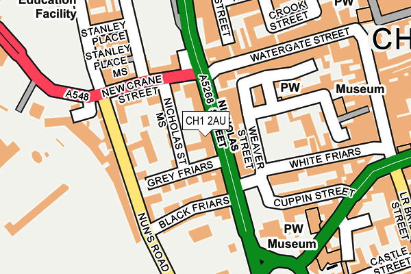
CH1 2AU lies on Nicholas Street in Chester. CH1 2AU is located in the Chester City & the Garden Quarter electoral ward, within the unitary authority of Cheshire West and Chester and the English Parliamentary constituency of City of Chester. The Sub Integrated Care Board (ICB) Location is NHS Cheshire and Merseyside ICB - 27D and the police force is Cheshire. This postcode has been in use since January 1980.


GetTheData
Source: OS OpenMap – Local (Ordnance Survey)
Source: OS VectorMap District (Ordnance Survey)
Licence: Open Government Licence (requires attribution)
| Easting | 340295 |
| Northing | 366121 |
| Latitude | 53.188812 |
| Longitude | -2.894997 |
GetTheData
Source: Open Postcode Geo
Licence: Open Government Licence
| Street | Nicholas Street |
| Town/City | Chester |
| Country | England |
| Postcode District | CH1 |
| ➜ CH1 open data dashboard ➜ See where CH1 is on a map ➜ Where is Chester? | |
GetTheData
Source: Land Registry Price Paid Data
Licence: Open Government Licence
Elevation or altitude of CH1 2AU as distance above sea level:
| Metres | Feet | |
|---|---|---|
| Elevation | 20m | 66ft |
Elevation is measured from the approximate centre of the postcode, to the nearest point on an OS contour line from OS Terrain 50, which has contour spacing of ten vertical metres.
➜ How high above sea level am I? Find the elevation of your current position using your device's GPS.
GetTheData
Source: Open Postcode Elevation
Licence: Open Government Licence
| Ward | Chester City & The Garden Quarter |
| Constituency | City Of Chester |
GetTheData
Source: ONS Postcode Database
Licence: Open Government Licence
| January 2024 | Anti-social behaviour | On or near Watergate Street | 172m |
| January 2024 | Other theft | On or near Watergate Street | 172m |
| January 2024 | Violence and sexual offences | On or near Watergate Street | 172m |
| ➜ Get more crime data in our Crime section | |||
GetTheData
Source: data.police.uk
Licence: Open Government Licence
| Nicholas Street Mews (Watergate Street) | Chester | 109m |
| Black Friars Coach Stop (Nicholas Street) | Chester | 120m |
| Watergate Street Coach Stop (St Martin's Way) | Chester | 136m |
| Black Friars (Nicholas Street) | Chester | 143m |
| New Crane Street Coach Stop (St Martin's Way) | Chester | 143m |
| Chester Station | 1.4km |
| Bache Station | 2.2km |
GetTheData
Source: NaPTAN
Licence: Open Government Licence
GetTheData
Source: ONS Postcode Database
Licence: Open Government Licence


➜ Get more ratings from the Food Standards Agency
GetTheData
Source: Food Standards Agency
Licence: FSA terms & conditions
| Last Collection | |||
|---|---|---|---|
| Location | Mon-Fri | Sat | Distance |
| Bridge Street. | 18:30 | 12:30 | 244m |
| Goss Street. | 18:15 | 13:00 | 259m |
| Town Hall. | 18:30 | 12:30 | 369m |
GetTheData
Source: Dracos
Licence: Creative Commons Attribution-ShareAlike
| Facility | Distance |
|---|---|
| The Chester Racecourse Polo Club Watergate Square, Chester Grass Pitches | 174m |
| Dutch Houses Fitness Centre (Chester) Ltd (Closed) Bridge Street Row West, Chester Health and Fitness Gym | 235m |
| Club Moativation (Chester) Trinity Street, Chester Health and Fitness Gym, Swimming Pool, Studio | 239m |
GetTheData
Source: Active Places
Licence: Open Government Licence
| School | Phase of Education | Distance |
|---|---|---|
| The Queen's School City Walls Road, Chester, CH1 2NN | Not applicable | 280m |
| Abbey School for Exceptional Children 10-12 Abbey Square, Chester, CH1 2HU | Not applicable | 476m |
| Chester International School Queens Park Campus, Queens Park Road, Handbridge, Chester, CH4 7AE | Secondary | 751m |
GetTheData
Source: Edubase
Licence: Open Government Licence
The below table lists the International Territorial Level (ITL) codes (formerly Nomenclature of Territorial Units for Statistics (NUTS) codes) and Local Administrative Units (LAU) codes for CH1 2AU:
| ITL 1 Code | Name |
|---|---|
| TLD | North West (England) |
| ITL 2 Code | Name |
| TLD6 | Cheshire |
| ITL 3 Code | Name |
| TLD63 | Cheshire West and Chester |
| LAU 1 Code | Name |
| E06000050 | Cheshire West and Chester |
GetTheData
Source: ONS Postcode Directory
Licence: Open Government Licence
The below table lists the Census Output Area (OA), Lower Layer Super Output Area (LSOA), and Middle Layer Super Output Area (MSOA) for CH1 2AU:
| Code | Name | |
|---|---|---|
| OA | E00092440 | |
| LSOA | E01018326 | Cheshire West and Chester 034A |
| MSOA | E02003803 | Cheshire West and Chester 034 |
GetTheData
Source: ONS Postcode Directory
Licence: Open Government Licence
| CH1 2NX | Nicholas Street | 9m |
| CH1 2NS | Nicholas Street Mews | 49m |
| CH1 2BQ | Weaver Street | 56m |
| CH1 2QS | Nicholas Court | 57m |
| CH1 2AB | Common Hall Street | 101m |
| CH1 2NW | Greyfriars | 109m |
| CH1 2NU | Black Friars | 109m |
| CH1 2LF | Watergate Street | 114m |
| CH1 2LZ | Nuns Road | 124m |
| CH1 2LR | Stanley Street | 135m |
GetTheData
Source: Open Postcode Geo; Land Registry Price Paid Data
Licence: Open Government Licence