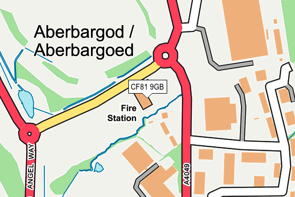
CF81 9GB is located in the Aberbargoed and Bargoed electoral ward, within the unitary authority of Caerphilly and the Welsh Parliamentary constituency of Islwyn. The Local Health Board is Aneurin Bevan University and the police force is Gwent. This postcode has been in use since September 2013.


GetTheData
Source: OS OpenMap – Local (Ordnance Survey)
Source: OS VectorMap District (Ordnance Survey)
Licence: Open Government Licence (requires attribution)
| Easting | 315824 |
| Northing | 199087 |
| Latitude | 51.684210 |
| Longitude | -3.218987 |
GetTheData
Source: Open Postcode Geo
Licence: Open Government Licence
| Country | Wales |
| Postcode District | CF81 |
| ➜ CF81 open data dashboard ➜ See where CF81 is on a map ➜ Where is Aberbargoed? | |
GetTheData
Source: Land Registry Price Paid Data
Licence: Open Government Licence
Elevation or altitude of CF81 9GB as distance above sea level:
| Metres | Feet | |
|---|---|---|
| Elevation | 200m | 656ft |
Elevation is measured from the approximate centre of the postcode, to the nearest point on an OS contour line from OS Terrain 50, which has contour spacing of ten vertical metres.
➜ How high above sea level am I? Find the elevation of your current position using your device's GPS.
GetTheData
Source: Open Postcode Elevation
Licence: Open Government Licence
| Ward | Aberbargoed And Bargoed |
| Constituency | Islwyn |
GetTheData
Source: ONS Postcode Database
Licence: Open Government Licence
| June 2022 | Public order | On or near Byron Road | 392m |
| June 2022 | Anti-social behaviour | On or near Britannia Walk | 447m |
| May 2022 | Burglary | On or near Marsh Court | 294m |
| ➜ Get more crime data in our Crime section | |||
GetTheData
Source: data.police.uk
Licence: Open Government Licence
| Britannia Walk (Pengam Road) | Britannia | 327m |
| Britannia Walk (Pengam Road) | Britannia | 392m |
| George Hotel (Commercial Street) | Aberbargoed | 474m |
| George Hotel (Commercial Street) | Aberbargoed | 498m |
| Britannia Terrace (Pengam Road) | Britannia | 581m |
| Gilfach Fargoed Station | 0.5km |
| Bargoed Station | 1.2km |
| Pengam Station | 1.7km |
GetTheData
Source: NaPTAN
Licence: Open Government Licence
GetTheData
Source: ONS Postcode Database
Licence: Open Government Licence


➜ Get more ratings from the Food Standards Agency
GetTheData
Source: Food Standards Agency
Licence: FSA terms & conditions
| Last Collection | |||
|---|---|---|---|
| Location | Mon-Fri | Sat | Distance |
| Argoed Post Office | 17:00 | 12:00 | 258m |
| Bargoed Post Office | 17:15 | 11:45 | 872m |
| Cefn Fforest Post Office | 17:00 | 12:00 | 1,326m |
GetTheData
Source: Dracos
Licence: Creative Commons Attribution-ShareAlike
| School | Phase of Education | Distance |
|---|---|---|
| Ysgol Bro Sannan Ty Fry Road, Aberbargoed, Bargoed, CF81 9FN | Not applicable | 617m |
| Ysgol Gymraeg Gilfach Fargoed Commercial Street, Gilfach, Bargoed, CF81 8JG | Not applicable | 876m |
| Park Primary School Bargoed Park Crescent, Bargoed, CF81 8PN | Not applicable | 985m |
GetTheData
Source: Edubase
Licence: Open Government Licence
The below table lists the International Territorial Level (ITL) codes (formerly Nomenclature of Territorial Units for Statistics (NUTS) codes) and Local Administrative Units (LAU) codes for CF81 9GB:
| ITL 1 Code | Name |
|---|---|
| TLL | Wales |
| ITL 2 Code | Name |
| TLL1 | West Wales and The Valleys |
| ITL 3 Code | Name |
| TLL16 | Gwent Valleys |
| LAU 1 Code | Name |
| W06000018 | Caerphilly |
GetTheData
Source: ONS Postcode Directory
Licence: Open Government Licence
The below table lists the Census Output Area (OA), Lower Layer Super Output Area (LSOA), and Middle Layer Super Output Area (MSOA) for CF81 9GB:
| Code | Name | |
|---|---|---|
| OA | W00006949 | |
| LSOA | W01001326 | Caerphilly 003B |
| MSOA | W02000292 | Caerphilly 003 |
GetTheData
Source: ONS Postcode Directory
Licence: Open Government Licence
| CF81 9FX | Gwaelod Y Waun Villas | 77m |
| CF81 9FW | Angel Lane | 133m |
| CF81 9EP | Bowen Industrial Estate | 280m |
| CF81 9BF | Marsh Court | 311m |
| CF81 9FT | Pengam Road | 327m |
| CF81 9FU | Pengam Road | 352m |
| NP12 3TH | Salway Avenue | 411m |
| CF81 9FS | Milton Close | 414m |
| NP12 3TQ | Britannia Walk | 454m |
| CF81 9FL | Ty Fry Road | 467m |
GetTheData
Source: Open Postcode Geo; Land Registry Price Paid Data
Licence: Open Government Licence