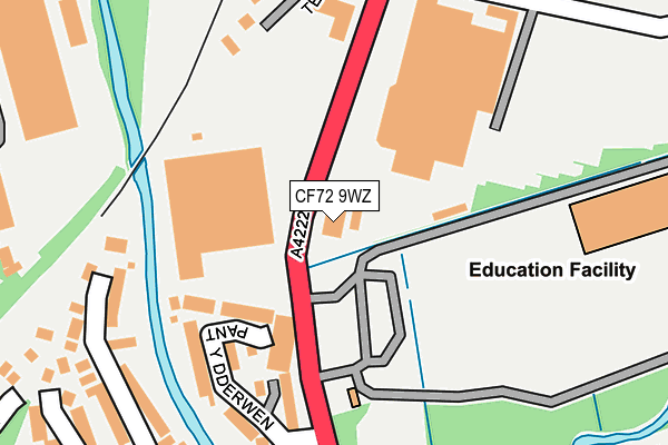
CF72 9WZ is located in the Llanharry electoral ward, within the unitary authority of Rhondda Cynon Taf and the Welsh Parliamentary constituency of Ogmore. The Local Health Board is Cwm Taf Morgannwg University and the police force is South Wales. This postcode has been in use since May 2022.


GetTheData
Source: OS OpenMap – Local (Ordnance Survey)
Source: OS VectorMap District (Ordnance Survey)
Licence: Open Government Licence (requires attribution)
| Easting | 301010 |
| Northing | 180502 |
| Latitude | 51.514740 |
| Longitude | -3.427963 |
GetTheData
Source: Open Postcode Geo
Licence: Open Government Licence
| Country | Wales |
| Postcode District | CF72 |
| ➜ CF72 open data dashboard ➜ See where CF72 is on a map ➜ Where is Llanharry? | |
GetTheData
Source: Land Registry Price Paid Data
Licence: Open Government Licence
Elevation or altitude of CF72 9WZ as distance above sea level:
| Metres | Feet | |
|---|---|---|
| Elevation | 50m | 164ft |
Elevation is measured from the approximate centre of the postcode, to the nearest point on an OS contour line from OS Terrain 50, which has contour spacing of ten vertical metres.
➜ How high above sea level am I? Find the elevation of your current position using your device's GPS.
GetTheData
Source: Open Postcode Elevation
Licence: Open Government Licence
| Ward | Llanharry |
| Constituency | Ogmore |
GetTheData
Source: ONS Postcode Database
Licence: Open Government Licence
| June 2022 | Public order | On or near The Patch | 111m |
| June 2022 | Violence and sexual offences | On or near Holly Road | 307m |
| June 2022 | Violence and sexual offences | On or near Holly Road | 307m |
| ➜ Get more crime data in our Crime section | |||
GetTheData
Source: data.police.uk
Licence: Open Government Licence
| Birch Grove (Llanharry Road) | Llanharry | 47m |
| Birch Grove (Llanharry Road) | Llanharry | 53m |
| The Bear Inn (Llanharry Road) | Llanharry | 228m |
| Tylacoch (Llanharry Road) | Llanharry | 231m |
| Tylacoch (Llanharry Road) | Llanharry | 242m |
| Pontyclun Station | 2.6km |
| Llanharan Station | 2.7km |
GetTheData
Source: NaPTAN
Licence: Open Government Licence
GetTheData
Source: ONS Postcode Database
Licence: Open Government Licence


➜ Get more ratings from the Food Standards Agency
GetTheData
Source: Food Standards Agency
Licence: FSA terms & conditions
| Last Collection | |||
|---|---|---|---|
| Location | Mon-Fri | Sat | Distance |
| Danygraig Drive | 17:15 | 11:15 | 1,159m |
| Gelli | 17:15 | 11:30 | 2,737m |
| Brynna Post Office | 16:45 | 11:45 | 2,884m |
GetTheData
Source: Dracos
Licence: Creative Commons Attribution-ShareAlike
| School | Phase of Education | Distance |
|---|---|---|
| Llanhari Primary School Aelfryn, Llanharry, Pontyclun, CF72 9LQ | Not applicable | 612m |
| Ysgol Llanhari Llanhari, Pontyclun, Rhondda, Cynon, Taff, CF72 9XE | Not applicable | 787m |
| Llansannor C.I.W. Primary School Llansannor, Ystradowen, Cowbridge, CF71 7SZ | Not applicable | 1.6km |
GetTheData
Source: Edubase
Licence: Open Government Licence
The below table lists the International Territorial Level (ITL) codes (formerly Nomenclature of Territorial Units for Statistics (NUTS) codes) and Local Administrative Units (LAU) codes for CF72 9WZ:
| ITL 1 Code | Name |
|---|---|
| TLL | Wales |
| ITL 2 Code | Name |
| TLL1 | West Wales and The Valleys |
| ITL 3 Code | Name |
| TLL15 | Central Valleys |
| LAU 1 Code | Name |
| W06000016 | Rhondda Cynon Taf |
GetTheData
Source: ONS Postcode Directory
Licence: Open Government Licence
The below table lists the Census Output Area (OA), Lower Layer Super Output Area (LSOA), and Middle Layer Super Output Area (MSOA) for CF72 9WZ:
| Code | Name | |
|---|---|---|
| OA | W00006278 | |
| LSOA | W01001191 | Rhondda Cynon Taf 031A |
| MSOA | W02000282 | Rhondda Cynon Taf 031 |
GetTheData
Source: ONS Postcode Directory
Licence: Open Government Licence
| CF72 9LT | Tyla Coch | 98m |
| CF72 9LF | The Patch | 103m |
| CF72 9HY | Birchgrove | 130m |
| CF72 9HZ | Birchgrove | 135m |
| CF72 9HQ | Alder Road | 182m |
| CF72 9HP | Sycamore Road | 189m |
| CF72 9LR | Tyla Coch | 202m |
| CF72 9HN | Sycamore Road | 226m |
| CF72 9HL | Sycamore Road | 234m |
| CF72 9LS | Tyla Coch | 267m |
GetTheData
Source: Open Postcode Geo; Land Registry Price Paid Data
Licence: Open Government Licence