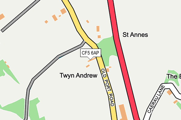
CF5 6AP lies on Old Port Road in Wenvoe, Cardiff. CF5 6AP is located in the Wenvoe electoral ward, within the unitary authority of Vale of Glamorgan and the Welsh Parliamentary constituency of Vale of Glamorgan. The Local Health Board is Cardiff and Vale University and the police force is South Wales. This postcode has been in use since January 1980.


GetTheData
Source: OS OpenMap – Local (Ordnance Survey)
Source: OS VectorMap District (Ordnance Survey)
Licence: Open Government Licence (requires attribution)
| Easting | 312055 |
| Northing | 173648 |
| Latitude | 51.454956 |
| Longitude | -3.267126 |
GetTheData
Source: Open Postcode Geo
Licence: Open Government Licence
| Street | Old Port Road |
| Locality | Wenvoe |
| Town/City | Cardiff |
| Country | Wales |
| Postcode District | CF5 |
| ➜ CF5 open data dashboard ➜ See where CF5 is on a map | |
GetTheData
Source: Land Registry Price Paid Data
Licence: Open Government Licence
Elevation or altitude of CF5 6AP as distance above sea level:
| Metres | Feet | |
|---|---|---|
| Elevation | 60m | 197ft |
Elevation is measured from the approximate centre of the postcode, to the nearest point on an OS contour line from OS Terrain 50, which has contour spacing of ten vertical metres.
➜ How high above sea level am I? Find the elevation of your current position using your device's GPS.
GetTheData
Source: Open Postcode Elevation
Licence: Open Government Licence
| Ward | Wenvoe |
| Constituency | Vale Of Glamorgan |
GetTheData
Source: ONS Postcode Database
Licence: Open Government Licence
| June 2022 | Other theft | On or near Nant Isaf | 282m |
| April 2022 | Vehicle crime | On or near Nant Isaf | 282m |
| March 2022 | Other theft | On or near Nant Isaf | 282m |
| ➜ Old Port Road crime map and outcomes | |||
GetTheData
Source: data.police.uk
Licence: Open Government Licence
| Wallston Castle (Port Road) | Wallston | 233m |
| The Alps (Port Road) | Wallston | 262m |
| Wallston Castle (Port Road) | Wallston | 306m |
| Alps (Port Road) | Twyn-yr-odyn | 371m |
| Station Road (Port Road) | Wenvoe | 708m |
| Dinas Powys Station | 4.3km |
| Waun-gron Park Station | 4.5km |
| Eastbrook Station | 4.7km |
GetTheData
Source: NaPTAN
Licence: Open Government Licence
| Percentage of properties with Next Generation Access | 100.0% |
| Percentage of properties with Superfast Broadband | 100.0% |
| Percentage of properties with Ultrafast Broadband | 0.0% |
| Percentage of properties with Full Fibre Broadband | 0.0% |
Superfast Broadband is between 30Mbps and 300Mbps
Ultrafast Broadband is > 300Mbps
| Percentage of properties unable to receive 2Mbps | 0.0% |
| Percentage of properties unable to receive 5Mbps | 0.0% |
| Percentage of properties unable to receive 10Mbps | 0.0% |
| Percentage of properties unable to receive 30Mbps | 0.0% |
GetTheData
Source: Ofcom
Licence: Ofcom Terms of Use (requires attribution)
GetTheData
Source: ONS Postcode Database
Licence: Open Government Licence


➜ Get more ratings from the Food Standards Agency
GetTheData
Source: Food Standards Agency
Licence: FSA terms & conditions
| Last Collection | |||
|---|---|---|---|
| Location | Mon-Fri | Sat | Distance |
| The Court | 15:30 | 10:30 | 2,580m |
| Caerau Post Office | 17:30 | 12:00 | 2,933m |
| Stumpy Lodge | 17:00 | 12:00 | 3,561m |
GetTheData
Source: Dracos
Licence: Creative Commons Attribution-ShareAlike
| School | Phase of Education | Distance |
|---|---|---|
| Gwenfo C.I.W. Primary Old Port Road, Wenvoe, Cardiff, CF5 6AN | Not applicable | 690m |
| Mary Immaculate R.C. High School Caerau Lane, Wenvoe, Cardiff, CF5 5QZ | Not applicable | 1.2km |
| Ely And Caerau Children's Centre Michaelston College, Michaelston Road, Cardiff, CF5 4SX | Not applicable | 2km |
GetTheData
Source: Edubase
Licence: Open Government Licence
The below table lists the International Territorial Level (ITL) codes (formerly Nomenclature of Territorial Units for Statistics (NUTS) codes) and Local Administrative Units (LAU) codes for CF5 6AP:
| ITL 1 Code | Name |
|---|---|
| TLL | Wales |
| ITL 2 Code | Name |
| TLL2 | East Wales |
| ITL 3 Code | Name |
| TLL22 | Cardiff and Vale of Glamorgan |
| LAU 1 Code | Name |
| W06000014 | Vale of Glamorgan |
GetTheData
Source: ONS Postcode Directory
Licence: Open Government Licence
The below table lists the Census Output Area (OA), Lower Layer Super Output Area (LSOA), and Middle Layer Super Output Area (MSOA) for CF5 6AP:
| Code | Name | |
|---|---|---|
| OA | W00005992 | |
| LSOA | W01001135 | The Vale of Glamorgan 003C |
| MSOA | W02000239 | The Vale of Glamorgan 003 |
GetTheData
Source: ONS Postcode Directory
Licence: Open Government Licence
| CF5 6BU | Greave Close | 317m |
| CF5 6BH | Hill Terrace | 376m |
| CF5 6DB | Whitehall Close | 417m |
| CF5 6AT | Grange Close | 429m |
| CF5 6BR | Gwenfo Drive | 434m |
| CF5 6BS | Ty Pica Drive | 445m |
| CF5 6BG | 454m | |
| CF5 6AB | Port Road | 454m |
| CF5 6BJ | Chapel Terrace | 511m |
| CF5 6AW | Walston Road | 534m |
GetTheData
Source: Open Postcode Geo; Land Registry Price Paid Data
Licence: Open Government Licence