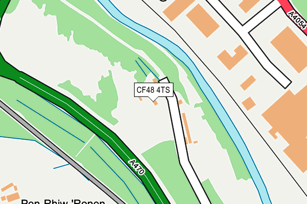
CF48 4TS is located in the Plymouth electoral ward, within the unitary authority of Merthyr Tydfil and the Welsh Parliamentary constituency of Merthyr Tydfil and Rhymney. The Local Health Board is Cwm Taf Morgannwg University and the police force is South Wales. This postcode has been in use since January 1980.


GetTheData
Source: OS OpenMap – Local (Ordnance Survey)
Source: OS VectorMap District (Ordnance Survey)
Licence: Open Government Licence (requires attribution)
| Easting | 306432 |
| Northing | 202973 |
| Latitude | 51.717651 |
| Longitude | -3.355845 |
GetTheData
Source: Open Postcode Geo
Licence: Open Government Licence
| Country | Wales |
| Postcode District | CF48 |
| ➜ CF48 open data dashboard ➜ See where CF48 is on a map | |
GetTheData
Source: Land Registry Price Paid Data
Licence: Open Government Licence
Elevation or altitude of CF48 4TS as distance above sea level:
| Metres | Feet | |
|---|---|---|
| Elevation | 160m | 525ft |
Elevation is measured from the approximate centre of the postcode, to the nearest point on an OS contour line from OS Terrain 50, which has contour spacing of ten vertical metres.
➜ How high above sea level am I? Find the elevation of your current position using your device's GPS.
GetTheData
Source: Open Postcode Elevation
Licence: Open Government Licence
| Ward | Plymouth |
| Constituency | Merthyr Tydfil And Rhymney |
GetTheData
Source: ONS Postcode Database
Licence: Open Government Licence
| May 2022 | Public order | On or near Arthur Street | 492m |
| May 2022 | Criminal damage and arson | On or near Arthur Street | 492m |
| April 2022 | Anti-social behaviour | On or near Arthur Street | 492m |
| ➜ Get more crime data in our Crime section | |||
GetTheData
Source: data.police.uk
Licence: Open Government Licence
| Merthyr Tydfil Ind Park (Merthyr Road) | Pentrebach | 312m |
| Merthyr Tydfil Ind Park (Merthyr Road) | Pentrebach | 330m |
| Spares World (Merthyr Road) | Pentrebach | 363m |
| Spares World (Merthyr Road) | Pentrebach | 377m |
| Rhydfach (Dyffryn Road) | Pentrebach | 441m |
| Troed-y-Rhiw Station | 0.9km |
| Pentre-Bach Station | 0.9km |
| Merthyr Tydfil Station | 3.3km |
GetTheData
Source: NaPTAN
Licence: Open Government Licence
| Percentage of properties with Next Generation Access | 100.0% |
| Percentage of properties with Superfast Broadband | 100.0% |
| Percentage of properties with Ultrafast Broadband | 0.0% |
| Percentage of properties with Full Fibre Broadband | 0.0% |
Superfast Broadband is between 30Mbps and 300Mbps
Ultrafast Broadband is > 300Mbps
| Percentage of properties unable to receive 2Mbps | 0.0% |
| Percentage of properties unable to receive 5Mbps | 0.0% |
| Percentage of properties unable to receive 10Mbps | 0.0% |
| Percentage of properties unable to receive 30Mbps | 0.0% |
GetTheData
Source: Ofcom
Licence: Ofcom Terms of Use (requires attribution)
GetTheData
Source: ONS Postcode Database
Licence: Open Government Licence


➜ Get more ratings from the Food Standards Agency
GetTheData
Source: Food Standards Agency
Licence: FSA terms & conditions
| Last Collection | |||
|---|---|---|---|
| Location | Mon-Fri | Sat | Distance |
| Pentrebach | 16:45 | 12:00 | 3,076m |
| Twyn Y Rodyn | 17:00 | 12:00 | 3,290m |
| Mountain Air | 17:00 | 11:30 | 3,337m |
GetTheData
Source: Dracos
Licence: Creative Commons Attribution-ShareAlike
| School | Phase of Education | Distance |
|---|---|---|
| Abercanaid Community School The Park, Abercanaid, Merthyr Tydfil, CF48 1SZ | Not applicable | 735m |
| Troedyrhiw Primary School Archer Street, Troedyrhiw, Merthyr Tydfil, CF48 4JQ | Not applicable | 735m |
| Greenfield Special School Duffryn Road, Pentrebach, Merthyr Tydfil, CF48 4BJ | Not applicable | 875m |
GetTheData
Source: Edubase
Licence: Open Government Licence
The below table lists the International Territorial Level (ITL) codes (formerly Nomenclature of Territorial Units for Statistics (NUTS) codes) and Local Administrative Units (LAU) codes for CF48 4TS:
| ITL 1 Code | Name |
|---|---|
| TLL | Wales |
| ITL 2 Code | Name |
| TLL1 | West Wales and The Valleys |
| ITL 3 Code | Name |
| TLL15 | Central Valleys |
| LAU 1 Code | Name |
| W06000024 | Merthyr Tydfil |
GetTheData
Source: ONS Postcode Directory
Licence: Open Government Licence
The below table lists the Census Output Area (OA), Lower Layer Super Output Area (LSOA), and Middle Layer Super Output Area (MSOA) for CF48 4TS:
| Code | Name | |
|---|---|---|
| OA | W00006883 | |
| LSOA | W01001312 | Merthyr Tydfil 006E |
| MSOA | W02000288 | Merthyr Tydfil 006 |
GetTheData
Source: ONS Postcode Directory
Licence: Open Government Licence
| CF48 4TR | Furnace Row | 83m |
| CF48 4DR | Merthyr Tydfil Industrial Park | 270m |
| CF48 4TP | Castle Houses | 375m |
| CF48 1HX | 436m | |
| CF48 4TW | Castle Terrace | 450m |
| CF48 4LA | Linde Industrial Park | 465m |
| CF48 4HU | Merthyr Road | 480m |
| CF48 4DH | Griffiths Terrace | 485m |
| CF48 4DG | Arthur Street | 502m |
| CF48 4DJ | Rhydfach | 502m |
GetTheData
Source: Open Postcode Geo; Land Registry Price Paid Data
Licence: Open Government Licence