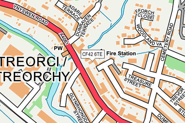
CF42 6TE lies on Bute Street in Treorchy. CF42 6TE is located in the Treorchy electoral ward, within the unitary authority of Rhondda Cynon Taf and the Welsh Parliamentary constituency of Rhondda. The Local Health Board is Cwm Taf Morgannwg University and the police force is South Wales. This postcode has been in use since January 1980.


GetTheData
Source: OS OpenMap – Local (Ordnance Survey)
Source: OS VectorMap District (Ordnance Survey)
Licence: Open Government Licence (requires attribution)
| Easting | 295440 |
| Northing | 197246 |
| Latitude | 51.664233 |
| Longitude | -3.513186 |
GetTheData
Source: Open Postcode Geo
Licence: Open Government Licence
| Street | Bute Street |
| Town/City | Treorchy |
| Country | Wales |
| Postcode District | CF42 |
| ➜ CF42 open data dashboard ➜ See where CF42 is on a map ➜ Where is Treorchy? | |
GetTheData
Source: Land Registry Price Paid Data
Licence: Open Government Licence
Elevation or altitude of CF42 6TE as distance above sea level:
| Metres | Feet | |
|---|---|---|
| Elevation | 170m | 558ft |
Elevation is measured from the approximate centre of the postcode, to the nearest point on an OS contour line from OS Terrain 50, which has contour spacing of ten vertical metres.
➜ How high above sea level am I? Find the elevation of your current position using your device's GPS.
GetTheData
Source: Open Postcode Elevation
Licence: Open Government Licence
| Ward | Treorchy |
| Constituency | Rhondda |
GetTheData
Source: ONS Postcode Database
Licence: Open Government Licence
OLDWAY HOUSE, BUTE STREET, TREORCHY, CF42 6TE 2009 28 AUG £165,000 |
OLDWAY HOUSE, BUTE STREET, TREORCHY, CF42 6TE 2007 23 APR £270,000 |
OLDWAY HOUSE, BUTE STREET, TREORCHY, CF42 6TE 2005 26 SEP £230,000 |
GetTheData
Source: HM Land Registry Price Paid Data
Licence: Contains HM Land Registry data © Crown copyright and database right 2024. This data is licensed under the Open Government Licence v3.0.
| January 2024 | Violence and sexual offences | On or near Ramah Street | 39m |
| January 2024 | Violence and sexual offences | On or near Ramah Street | 39m |
| November 2023 | Violence and sexual offences | On or near Ramah Street | 39m |
| ➜ Get more crime data in our Crime section | |||
GetTheData
Source: data.police.uk
Licence: Open Government Licence
| Dunraven Terrace (Ynyswen Road) | Ynys-wen | 82m |
| Dunraven Terrace (Ynyswen Road) | Ynys-wen | 87m |
| Cardiff Arms (Bute Street) | Treorchy | 200m |
| Treorchy Cemetery (Cemetery Road) | Ynys-wen | 310m |
| Cardiff Arms (Bute Street) | Treorchy | 316m |
| Ynyswen Station | 0.6km |
| Treorchy Station | 0.9km |
| Treherbert Station | 1.8km |
GetTheData
Source: NaPTAN
Licence: Open Government Licence
GetTheData
Source: ONS Postcode Database
Licence: Open Government Licence


➜ Get more ratings from the Food Standards Agency
GetTheData
Source: Food Standards Agency
Licence: FSA terms & conditions
| Last Collection | |||
|---|---|---|---|
| Location | Mon-Fri | Sat | Distance |
| Bute Street | 16:30 | 11:30 | 261m |
| Treorchy Post Office | 18:00 | 12:30 | 787m |
| Bute Street | 16:15 | 11:15 | 1,511m |
GetTheData
Source: Dracos
Licence: Creative Commons Attribution-ShareAlike
| School | Phase of Education | Distance |
|---|---|---|
| Ysgol G.G. Ynyswen Clinic Road, Ynyswen, Treorci, Rhondda, Cynon, Taff, CF42 6ED | Not applicable | 486m |
| Treorchy Comprehensive School Pengelli, Treorchy, Rhondda, CF42 6UL | Not applicable | 603m |
| Treorchy Primary School Glyncoli Road, Treorchy, Rhondda, CF42 6SA | Not applicable | 632m |
GetTheData
Source: Edubase
Licence: Open Government Licence
The below table lists the International Territorial Level (ITL) codes (formerly Nomenclature of Territorial Units for Statistics (NUTS) codes) and Local Administrative Units (LAU) codes for CF42 6TE:
| ITL 1 Code | Name |
|---|---|
| TLL | Wales |
| ITL 2 Code | Name |
| TLL1 | West Wales and The Valleys |
| ITL 3 Code | Name |
| TLL15 | Central Valleys |
| LAU 1 Code | Name |
| W06000016 | Rhondda Cynon Taf |
GetTheData
Source: ONS Postcode Directory
Licence: Open Government Licence
The below table lists the Census Output Area (OA), Lower Layer Super Output Area (LSOA), and Middle Layer Super Output Area (MSOA) for CF42 6TE:
| Code | Name | |
|---|---|---|
| OA | W00006669 | |
| LSOA | W01001273 | Rhondda Cynon Taf 010E |
| MSOA | W02000261 | Rhondda Cynon Taf 010 |
GetTheData
Source: ONS Postcode Directory
Licence: Open Government Licence
| CF42 6TL | Ramah Street | 36m |
| CF42 6TN | Dumfries Street | 87m |
| CF42 6DA | Bute Street | 98m |
| CF42 6DD | Glan Yr Afon | 102m |
| CF42 6DB | Bute Street | 116m |
| CF42 6EL | Dunraven Terrace | 133m |
| CF42 6TH | Treasure Street | 147m |
| CF42 6DE | Glynrhondda Street | 149m |
| CF42 6TT | Woodland Vale | 158m |
| CF42 6TW | Dumfries Street | 192m |
GetTheData
Source: Open Postcode Geo; Land Registry Price Paid Data
Licence: Open Government Licence