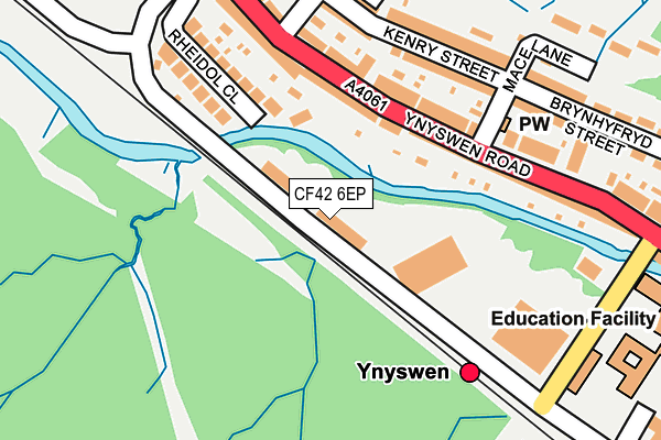
CF42 6EP is located in the Treorchy electoral ward, within the unitary authority of Rhondda Cynon Taf and the Welsh Parliamentary constituency of Rhondda. The Local Health Board is Cwm Taf Morgannwg University and the police force is South Wales. This postcode has been in use since December 1994.


GetTheData
Source: OS OpenMap – Local (Ordnance Survey)
Source: OS VectorMap District (Ordnance Survey)
Licence: Open Government Licence (requires attribution)
| Easting | 294718 |
| Northing | 197495 |
| Latitude | 51.666340 |
| Longitude | -3.523707 |
GetTheData
Source: Open Postcode Geo
Licence: Open Government Licence
| Country | Wales |
| Postcode District | CF42 |
| ➜ CF42 open data dashboard ➜ See where CF42 is on a map ➜ Where is Treorchy? | |
GetTheData
Source: Land Registry Price Paid Data
Licence: Open Government Licence
Elevation or altitude of CF42 6EP as distance above sea level:
| Metres | Feet | |
|---|---|---|
| Elevation | 170m | 558ft |
Elevation is measured from the approximate centre of the postcode, to the nearest point on an OS contour line from OS Terrain 50, which has contour spacing of ten vertical metres.
➜ How high above sea level am I? Find the elevation of your current position using your device's GPS.
GetTheData
Source: Open Postcode Elevation
Licence: Open Government Licence
| Ward | Treorchy |
| Constituency | Rhondda |
GetTheData
Source: ONS Postcode Database
Licence: Open Government Licence
| June 2022 | Criminal damage and arson | On or near Mace Lane | 199m |
| June 2022 | Violence and sexual offences | On or near Mace Lane | 199m |
| June 2022 | Violence and sexual offences | On or near Mace Lane | 199m |
| ➜ Get more crime data in our Crime section | |||
GetTheData
Source: data.police.uk
Licence: Open Government Licence
| Payne`s Shop (Ynyswen Road) | Ynys-wen | 131m |
| Payne`s Shop (Ynyswen Road) | Ynys-wen | 149m |
| Penyrenglyn School (Baglan Street) | Pen-yr-englyn | 247m |
| Railway Station (Ynyswen Road) | Ynys-wen | 318m |
| Forest View Health Centre (Abergorki Industrial Estate) | Treorchy | 339m |
| Ynyswen Station | 0.2km |
| Treherbert Station | 1.1km |
| Treorchy Station | 1.6km |
GetTheData
Source: NaPTAN
Licence: Open Government Licence
GetTheData
Source: ONS Postcode Database
Licence: Open Government Licence


➜ Get more ratings from the Food Standards Agency
GetTheData
Source: Food Standards Agency
Licence: FSA terms & conditions
| Last Collection | |||
|---|---|---|---|
| Location | Mon-Fri | Sat | Distance |
| Bute Street | 16:15 | 11:15 | 813m |
| Bute Street | 16:30 | 11:30 | 993m |
| Treorchy Post Office | 18:00 | 12:30 | 1,523m |
GetTheData
Source: Dracos
Licence: Creative Commons Attribution-ShareAlike
| School | Phase of Education | Distance |
|---|---|---|
| Ysgol G.G. Ynyswen Clinic Road, Ynyswen, Treorci, Rhondda, Cynon, Taff, CF42 6ED | Not applicable | 278m |
| Penyrenglyn Primary School Baglan Street, Treherbert, Treorchy, CF42 5AF | Not applicable | 470m |
| Treorchy Comprehensive School Pengelli, Treorchy, Rhondda, CF42 6UL | Not applicable | 1.2km |
GetTheData
Source: Edubase
Licence: Open Government Licence
The below table lists the International Territorial Level (ITL) codes (formerly Nomenclature of Territorial Units for Statistics (NUTS) codes) and Local Administrative Units (LAU) codes for CF42 6EP:
| ITL 1 Code | Name |
|---|---|
| TLL | Wales |
| ITL 2 Code | Name |
| TLL1 | West Wales and The Valleys |
| ITL 3 Code | Name |
| TLL15 | Central Valleys |
| LAU 1 Code | Name |
| W06000016 | Rhondda Cynon Taf |
GetTheData
Source: ONS Postcode Directory
Licence: Open Government Licence
The below table lists the Census Output Area (OA), Lower Layer Super Output Area (LSOA), and Middle Layer Super Output Area (MSOA) for CF42 6EP:
| Code | Name | |
|---|---|---|
| OA | W00006668 | |
| LSOA | W01001272 | Rhondda Cynon Taf 010D |
| MSOA | W02000261 | Rhondda Cynon Taf 010 |
GetTheData
Source: ONS Postcode Directory
Licence: Open Government Licence
| CF42 6ED | Ynyswen Road | 161m |
| CF42 5AR | Baglan Street | 170m |
| CF42 5AP | Rheidol Close | 184m |
| CF42 5AS | Baglan Street | 198m |
| CF42 6EB | Ynyswen Road | 198m |
| CF42 6DR | Kenry Street | 199m |
| CF42 5BA | Llewellyn Street | 214m |
| CF42 5AT | Jones Street | 264m |
| CF42 5AU | Painters Row | 269m |
| CF42 6DT | Brynhyfryd Street | 272m |
GetTheData
Source: Open Postcode Geo; Land Registry Price Paid Data
Licence: Open Government Licence