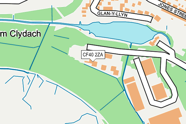
CF40 2ZA is located in the Cwm Clydach electoral ward, within the unitary authority of Rhondda Cynon Taf and the Welsh Parliamentary constituency of Rhondda. The Local Health Board is Cwm Taf Morgannwg University and the police force is South Wales. This postcode has been in use since February 2005.


GetTheData
Source: OS OpenMap – Local (Ordnance Survey)
Source: OS VectorMap District (Ordnance Survey)
Licence: Open Government Licence (requires attribution)
| Easting | 298090 |
| Northing | 192729 |
| Latitude | 51.624120 |
| Longitude | -3.473567 |
GetTheData
Source: Open Postcode Geo
Licence: Open Government Licence
| Country | Wales |
| Postcode District | CF40 |
| ➜ CF40 open data dashboard ➜ See where CF40 is on a map ➜ Where is Tonypandy? | |
GetTheData
Source: Land Registry Price Paid Data
Licence: Open Government Licence
Elevation or altitude of CF40 2ZA as distance above sea level:
| Metres | Feet | |
|---|---|---|
| Elevation | 200m | 656ft |
Elevation is measured from the approximate centre of the postcode, to the nearest point on an OS contour line from OS Terrain 50, which has contour spacing of ten vertical metres.
➜ How high above sea level am I? Find the elevation of your current position using your device's GPS.
GetTheData
Source: Open Postcode Elevation
Licence: Open Government Licence
| Ward | Cwm Clydach |
| Constituency | Rhondda |
GetTheData
Source: ONS Postcode Database
Licence: Open Government Licence
| June 2022 | Anti-social behaviour | On or near Park/Open Space | 132m |
| June 2022 | Drugs | On or near Brynheulog Terrace | 272m |
| June 2022 | Vehicle crime | On or near Glyn Terrace | 379m |
| ➜ Get more crime data in our Crime section | |||
GetTheData
Source: data.police.uk
Licence: Open Government Licence
| Noddfa Chapel (Clydach Road) | Blaen Clydach | 312m |
| Bush Hotel (Clydach Road) | Blaen Clydach | 313m |
| Bush Hotel (Clydach Road) | Blaen Clydach | 317m |
| Noddfa Chapel (Clydach Road) | Blaen Clydach | 319m |
| Cwm Clydach School (Clydach Road) | Clydach Vale | 365m |
| Llwynypia Station | 1.8km |
| Tonypandy Station | 1.8km |
| Ystrad Rhondda Station | 2.2km |
GetTheData
Source: NaPTAN
Licence: Open Government Licence
GetTheData
Source: ONS Postcode Database
Licence: Open Government Licence


➜ Get more ratings from the Food Standards Agency
GetTheData
Source: Food Standards Agency
Licence: FSA terms & conditions
| Last Collection | |||
|---|---|---|---|
| Location | Mon-Fri | Sat | Distance |
| Lower Trealaw | 17:15 | 11:00 | 1,857m |
| Smith Street | 16:30 | 11:00 | 2,254m |
| Ty Isaf Road Gelli | 16:30 | 11:00 | 2,274m |
GetTheData
Source: Dracos
Licence: Creative Commons Attribution-ShareAlike
| School | Phase of Education | Distance |
|---|---|---|
| Cwmclydach Primary Wern Street, Clydach Vale, Tonypandy, CF40 2BQ | Not applicable | 333m |
| Llwynypia Primary School School Terrace, Llwynypia, Tonypandy, CF40 2HL | Not applicable | 1km |
| St Gabriel & Raphael R.C.P. School Primrose Street, Tonypandy, CF40 1BJ | Not applicable | 1.5km |
GetTheData
Source: Edubase
Licence: Open Government Licence
The below table lists the International Territorial Level (ITL) codes (formerly Nomenclature of Territorial Units for Statistics (NUTS) codes) and Local Administrative Units (LAU) codes for CF40 2ZA:
| ITL 1 Code | Name |
|---|---|
| TLL | Wales |
| ITL 2 Code | Name |
| TLL1 | West Wales and The Valleys |
| ITL 3 Code | Name |
| TLL15 | Central Valleys |
| LAU 1 Code | Name |
| W06000016 | Rhondda Cynon Taf |
GetTheData
Source: ONS Postcode Directory
Licence: Open Government Licence
The below table lists the Census Output Area (OA), Lower Layer Super Output Area (LSOA), and Middle Layer Super Output Area (MSOA) for CF40 2ZA:
| Code | Name | |
|---|---|---|
| OA | W00006152 | |
| LSOA | W01001167 | Rhondda Cynon Taf 016B |
| MSOA | W02000267 | Rhondda Cynon Taf 016 |
GetTheData
Source: ONS Postcode Directory
Licence: Open Government Licence
| CF40 2BA | Glan Y Llyn | 190m |
| CF40 2XX | Cambrian Industrial Park | 234m |
| CF40 2BX | Brynheulog Terrace | 272m |
| CF40 2BE | Taff Terrace | 274m |
| CF40 2BD | Clydach Road | 308m |
| CF40 2BY | Jones Street | 316m |
| CF40 2DQ | Clydach Road | 330m |
| CF40 2DG | Clydach Road | 332m |
| CF40 2BU | Park Street | 337m |
| CF40 2ED | Evans Terrace | 369m |
GetTheData
Source: Open Postcode Geo; Land Registry Price Paid Data
Licence: Open Government Licence