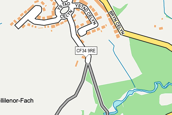
CF34 9RE is located in the Maesteg West electoral ward, within the unitary authority of Bridgend and the Welsh Parliamentary constituency of Ogmore. The Local Health Board is Cwm Taf Morgannwg University and the police force is South Wales. This postcode has been in use since January 1980.


GetTheData
Source: OS OpenMap – Local (Ordnance Survey)
Source: OS VectorMap District (Ordnance Survey)
Licence: Open Government Licence (requires attribution)
| Easting | 285395 |
| Northing | 189975 |
| Latitude | 51.596924 |
| Longitude | -3.655977 |
GetTheData
Source: Open Postcode Geo
Licence: Open Government Licence
| Country | Wales |
| Postcode District | CF34 |
| ➜ CF34 open data dashboard ➜ See where CF34 is on a map | |
GetTheData
Source: Land Registry Price Paid Data
Licence: Open Government Licence
Elevation or altitude of CF34 9RE as distance above sea level:
| Metres | Feet | |
|---|---|---|
| Elevation | 160m | 525ft |
Elevation is measured from the approximate centre of the postcode, to the nearest point on an OS contour line from OS Terrain 50, which has contour spacing of ten vertical metres.
➜ How high above sea level am I? Find the elevation of your current position using your device's GPS.
GetTheData
Source: Open Postcode Elevation
Licence: Open Government Licence
| Ward | Maesteg West |
| Constituency | Ogmore |
GetTheData
Source: ONS Postcode Database
Licence: Open Government Licence
| May 2022 | Anti-social behaviour | On or near Ystad Celyn | 200m |
| May 2022 | Anti-social behaviour | On or near Ystad Celyn | 200m |
| March 2022 | Violence and sexual offences | On or near St David'S Place | 431m |
| ➜ Get more crime data in our Crime section | |||
GetTheData
Source: data.police.uk
Licence: Open Government Licence
| Red Cow (Alma Road) | Maesteg | 302m |
| St Davids Place | Llwydarth | 427m |
| Cross Inn (Llwydarth Road) | Cwmfelin | 509m |
| Cross Inn (Llwydarth Road) | Cwmfelin | 517m |
| Kier Hardie Road (Brynllywarch) | Llwydarth | 582m |
| Garth (Bridgend) Station | 1km |
| Maesteg (Ewenny Road) Station | 1.1km |
| Maesteg Station | 1.5km |
GetTheData
Source: NaPTAN
Licence: Open Government Licence
| Percentage of properties with Next Generation Access | 100.0% |
| Percentage of properties with Superfast Broadband | 100.0% |
| Percentage of properties with Ultrafast Broadband | 0.0% |
| Percentage of properties with Full Fibre Broadband | 0.0% |
Superfast Broadband is between 30Mbps and 300Mbps
Ultrafast Broadband is > 300Mbps
| Percentage of properties unable to receive 2Mbps | 0.0% |
| Percentage of properties unable to receive 5Mbps | 0.0% |
| Percentage of properties unable to receive 10Mbps | 0.0% |
| Percentage of properties unable to receive 30Mbps | 0.0% |
GetTheData
Source: Ofcom
Licence: Ofcom Terms of Use (requires attribution)
GetTheData
Source: ONS Postcode Database
Licence: Open Government Licence


➜ Get more ratings from the Food Standards Agency
GetTheData
Source: Food Standards Agency
Licence: FSA terms & conditions
| Last Collection | |||
|---|---|---|---|
| Location | Mon-Fri | Sat | Distance |
| Talbot Street | 17:30 | 12:00 | 1,394m |
| Castle Street | 16:45 | 10:30 | 1,401m |
GetTheData
Source: Dracos
Licence: Creative Commons Attribution-ShareAlike
| School | Phase of Education | Distance |
|---|---|---|
| YGG Cynwyd Sant Pen-Yr-Ysgol, Maesteg, Bridgend, CF34 9YE | Not applicable | 819m |
| Cwmfelin Primary School Maesteg Road, Cwmfelin, Maesteg, Bridgend, CF34 9LD | Not applicable | 998m |
| St Mary's & St Patrick's Catholic Primary School Monica Street, Maesteg, Bridgend, CF34 9AY | Not applicable | 1km |
GetTheData
Source: Edubase
Licence: Open Government Licence
The below table lists the International Territorial Level (ITL) codes (formerly Nomenclature of Territorial Units for Statistics (NUTS) codes) and Local Administrative Units (LAU) codes for CF34 9RE:
| ITL 1 Code | Name |
|---|---|
| TLL | Wales |
| ITL 2 Code | Name |
| TLL1 | West Wales and The Valleys |
| ITL 3 Code | Name |
| TLL17 | Bridgend and Neath Port Talbot |
| LAU 1 Code | Name |
| W06000013 | Bridgend |
GetTheData
Source: ONS Postcode Directory
Licence: Open Government Licence
The below table lists the Census Output Area (OA), Lower Layer Super Output Area (LSOA), and Middle Layer Super Output Area (MSOA) for CF34 9RE:
| Code | Name | |
|---|---|---|
| OA | W00005402 | |
| LSOA | W01001019 | Bridgend 005D |
| MSOA | W02000222 | Bridgend 005 |
GetTheData
Source: ONS Postcode Directory
Licence: Open Government Licence
| CF34 9LT | Ystad Celyn | 193m |
| CF34 9LS | Bryn Celyn Lane | 222m |
| CF34 9LR | St Davids Place | 415m |
| CF34 9HW | Llan Road | 416m |
| CF34 9HN | Llan Road | 438m |
| CF34 9AW | Alma Road | 477m |
| CF34 9BE | Yr Ysfa | 524m |
| CF34 9LP | Fairfield Avenue | 530m |
| CF34 9LY | Lansbury Crescent | 541m |
| CF34 9NR | St Cynwyds Avenue | 564m |
GetTheData
Source: Open Postcode Geo; Land Registry Price Paid Data
Licence: Open Government Licence