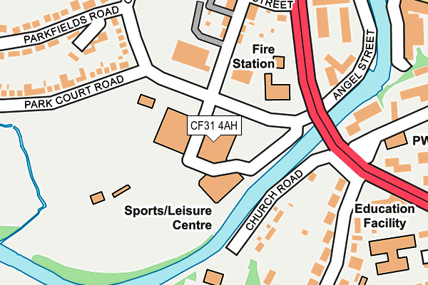
CF31 4AH is located in the Bridgend Central electoral ward, within the unitary authority of Bridgend and the Welsh Parliamentary constituency of Bridgend. The Local Health Board is Cwm Taf Morgannwg University and the police force is South Wales. This postcode has been in use since January 1980.


GetTheData
Source: OS OpenMap – Local (Ordnance Survey)
Source: OS VectorMap District (Ordnance Survey)
Licence: Open Government Licence (requires attribution)
| Easting | 290270 |
| Northing | 179440 |
| Latitude | 51.503209 |
| Longitude | -3.582352 |
GetTheData
Source: Open Postcode Geo
Licence: Open Government Licence
| Country | Wales |
| Postcode District | CF31 |
| ➜ CF31 open data dashboard ➜ See where CF31 is on a map ➜ Where is Bridgend? | |
GetTheData
Source: Land Registry Price Paid Data
Licence: Open Government Licence
Elevation or altitude of CF31 4AH as distance above sea level:
| Metres | Feet | |
|---|---|---|
| Elevation | 20m | 66ft |
Elevation is measured from the approximate centre of the postcode, to the nearest point on an OS contour line from OS Terrain 50, which has contour spacing of ten vertical metres.
➜ How high above sea level am I? Find the elevation of your current position using your device's GPS.
GetTheData
Source: Open Postcode Elevation
Licence: Open Government Licence
| Ward | Bridgend Central |
| Constituency | Bridgend |
GetTheData
Source: ONS Postcode Database
Licence: Open Government Licence
| January 2024 | Criminal damage and arson | On or near Parking Area | 478m |
| January 2024 | Violence and sexual offences | On or near Parking Area | 478m |
| January 2024 | Violence and sexual offences | On or near Parking Area | 478m |
| ➜ Get more crime data in our Crime section | |||
GetTheData
Source: data.police.uk
Licence: Open Government Licence
| Recreation Centre (Angel Street) | Bridgend | 48m |
| Recreation Centre (Angel Street) | Bridgend | 64m |
| Newbridge Fields (Park Court Road) | Newcastle | 299m |
| Nolton Street | Bridgend | 443m |
| Nolton Street | Bridgend | 449m |
| Bridgend Station | 0.6km |
| Wildmill Station | 2km |
| Sarn Station | 4km |
GetTheData
Source: NaPTAN
Licence: Open Government Licence
GetTheData
Source: ONS Postcode Database
Licence: Open Government Licence


➜ Get more ratings from the Food Standards Agency
GetTheData
Source: Food Standards Agency
Licence: FSA terms & conditions
| Last Collection | |||
|---|---|---|---|
| Location | Mon-Fri | Sat | Distance |
| Grove Road | 17:30 | 12:00 | 371m |
| Caroline Street | 17:30 | 12:00 | 427m |
| Dunraven Place | 17:45 | 12:30 | 469m |
GetTheData
Source: Dracos
Licence: Creative Commons Attribution-ShareAlike
| School | Phase of Education | Distance |
|---|---|---|
| Brynteg Comprehensive School Ewenny Road, Bridgend, CF31 3ER | Not applicable | 673m |
| St Mary's Catholic Primary School Llangewydd Road, Bridgend, CF31 4JW | Not applicable | 708m |
| Heronsbridge School Ewenny Road, Bridgend, CF31 3HT | Not applicable | 708m |
GetTheData
Source: Edubase
Licence: Open Government Licence
The below table lists the International Territorial Level (ITL) codes (formerly Nomenclature of Territorial Units for Statistics (NUTS) codes) and Local Administrative Units (LAU) codes for CF31 4AH:
| ITL 1 Code | Name |
|---|---|
| TLL | Wales |
| ITL 2 Code | Name |
| TLL1 | West Wales and The Valleys |
| ITL 3 Code | Name |
| TLL17 | Bridgend and Neath Port Talbot |
| LAU 1 Code | Name |
| W06000013 | Bridgend |
GetTheData
Source: ONS Postcode Directory
Licence: Open Government Licence
The below table lists the Census Output Area (OA), Lower Layer Super Output Area (LSOA), and Middle Layer Super Output Area (MSOA) for CF31 4AH:
| Code | Name | |
|---|---|---|
| OA | W00005441 | |
| LSOA | W01001028 | Bridgend 014D |
| MSOA | W02000231 | Bridgend 014 |
GetTheData
Source: ONS Postcode Directory
Licence: Open Government Licence
| CF31 3AZ | Church Road | 159m |
| CF31 4AF | Sunnyside Road | 202m |
| CF31 4BS | Glan Y Parc | 221m |
| CF31 4AG | Rice Street | 226m |
| CF31 4BW | Park Court Road | 234m |
| CF31 3NR | Merthyrmawr Road | 255m |
| CF31 3NG | Merthyr Mawr Road North | 256m |
| CF31 3NW | Merthyrmawr Road | 271m |
| CF31 4BH | Parkfields Road | 276m |
| CF31 3NN | Merthyrmawr Road | 282m |
GetTheData
Source: Open Postcode Geo; Land Registry Price Paid Data
Licence: Open Government Licence