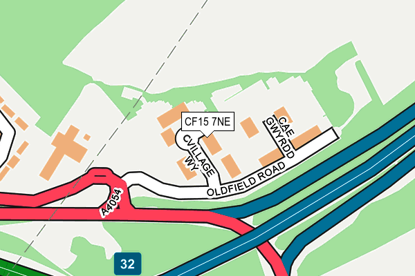
CF15 7NE lies on Village Way in Tongwynlais, Cardiff. CF15 7NE is located in the Whitchurch and Tongwynlais electoral ward, within the unitary authority of Cardiff and the Welsh Parliamentary constituency of Cardiff North. The Local Health Board is Cardiff and Vale University and the police force is South Wales. This postcode has been in use since September 2003.


GetTheData
Source: OS OpenMap – Local (Ordnance Survey)
Source: OS VectorMap District (Ordnance Survey)
Licence: Open Government Licence (requires attribution)
| Easting | 314161 |
| Northing | 181858 |
| Latitude | 51.529084 |
| Longitude | -3.238822 |
GetTheData
Source: Open Postcode Geo
Licence: Open Government Licence
| Street | Village Way |
| Locality | Tongwynlais |
| Town/City | Cardiff |
| Country | Wales |
| Postcode District | CF15 |
| ➜ CF15 open data dashboard ➜ See where CF15 is on a map ➜ Where is Tongwynlais? | |
GetTheData
Source: Land Registry Price Paid Data
Licence: Open Government Licence
Elevation or altitude of CF15 7NE as distance above sea level:
| Metres | Feet | |
|---|---|---|
| Elevation | 70m | 230ft |
Elevation is measured from the approximate centre of the postcode, to the nearest point on an OS contour line from OS Terrain 50, which has contour spacing of ten vertical metres.
➜ How high above sea level am I? Find the elevation of your current position using your device's GPS.
GetTheData
Source: Open Postcode Elevation
Licence: Open Government Licence
| Ward | Whitchurch And Tongwynlais |
| Constituency | Cardiff North |
GetTheData
Source: ONS Postcode Database
Licence: Open Government Licence
| June 2023 | Other theft | On or near Dan Y Graig | 429m |
| June 2022 | Criminal damage and arson | On or near Oldfield Road | 91m |
| June 2022 | Anti-social behaviour | On or near Pedestrian Subway | 348m |
| ➜ Village Way crime map and outcomes | |||
GetTheData
Source: data.police.uk
Licence: Open Government Licence
| Cardiff International Hotel (Merthyr Road) | Tongwynlais | 181m |
| Cardiff International Hotel (Merthyr Road) | Coryton | 235m |
| Quality Hotel (Merthyr Road) | Tongwynlais | 393m |
| Quality Hotel (Merthyr Road) | Tongwynlais | 408m |
| Dan Y Graig | Pantmawr | 418m |
| Coryton Station | 1.1km |
| Whitchurch (Cardiff) Station | 1.4km |
| Radyr Station | 1.6km |
GetTheData
Source: NaPTAN
Licence: Open Government Licence
GetTheData
Source: ONS Postcode Database
Licence: Open Government Licence


➜ Get more ratings from the Food Standards Agency
GetTheData
Source: Food Standards Agency
Licence: FSA terms & conditions
| Last Collection | |||
|---|---|---|---|
| Location | Mon-Fri | Sat | Distance |
| Capel Gwyliam | 16:45 | 12:00 | 587m |
| Coryton Crescent | 17:45 | 12:00 | 690m |
| Tongwynlais Post Office | 17:15 | 12:00 | 920m |
GetTheData
Source: Dracos
Licence: Creative Commons Attribution-ShareAlike
| School | Phase of Education | Distance |
|---|---|---|
| Coryton Primary School Hollybush Estate, Whitchurch, Cardiff, CF14 7DS | Not applicable | 766m |
| Tongwynlais Primary School Merthyr Road, Tongwynlais, Cardiff, CF15 7LF | Not applicable | 857m |
| Greenhill Special School Heol Brynglas, Rhiwbina, Cardiff, CF14 6UJ | Not applicable | 1.3km |
GetTheData
Source: Edubase
Licence: Open Government Licence
The below table lists the International Territorial Level (ITL) codes (formerly Nomenclature of Territorial Units for Statistics (NUTS) codes) and Local Administrative Units (LAU) codes for CF15 7NE:
| ITL 1 Code | Name |
|---|---|
| TLL | Wales |
| ITL 2 Code | Name |
| TLL2 | East Wales |
| ITL 3 Code | Name |
| TLL22 | Cardiff and Vale of Glamorgan |
| LAU 1 Code | Name |
| W06000015 | Cardiff |
GetTheData
Source: ONS Postcode Directory
Licence: Open Government Licence
The below table lists the Census Output Area (OA), Lower Layer Super Output Area (LSOA), and Middle Layer Super Output Area (MSOA) for CF15 7NE:
| Code | Name | |
|---|---|---|
| OA | W00009721 | |
| LSOA | W01001893 | Cardiff 010B |
| MSOA | W02000376 | Cardiff 010 |
GetTheData
Source: ONS Postcode Directory
Licence: Open Government Licence
| CF15 7AB | Cae Gwyrdd | 132m |
| CF15 7LW | Green Meadow Drive | 313m |
| CF15 7LY | Castle View | 390m |
| CF15 7LT | Pantgwynlais | 416m |
| CF15 7HX | Pwllhelyg | 445m |
| CF14 7HL | Dan Y Graig | 453m |
| CF14 7HJ | Dan Y Graig | 461m |
| CF14 7HH | Bryn Adar | 477m |
| CF15 7LU | Green Meadow Drive | 479m |
| CF14 7EQ | Coryton Crescent | 517m |
GetTheData
Source: Open Postcode Geo; Land Registry Price Paid Data
Licence: Open Government Licence