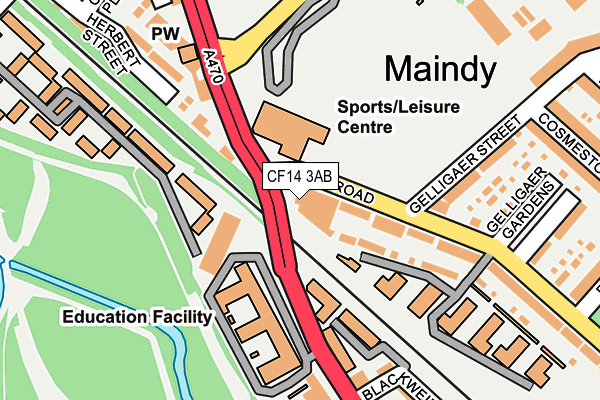
CF14 3AB is located in the Cathays electoral ward, within the unitary authority of Cardiff and the Welsh Parliamentary constituency of Cardiff Central. The Local Health Board is Cardiff and Vale University and the police force is South Wales. This postcode has been in use since November 2010.


GetTheData
Source: OS OpenMap – Local (Ordnance Survey)
Source: OS VectorMap District (Ordnance Survey)
Licence: Open Government Licence (requires attribution)
| Easting | 317410 |
| Northing | 178118 |
| Latitude | 51.495947 |
| Longitude | -3.191110 |
GetTheData
Source: Open Postcode Geo
Licence: Open Government Licence
| Country | Wales |
| Postcode District | CF14 |
| ➜ CF14 open data dashboard ➜ See where CF14 is on a map ➜ Where is Cardiff? | |
GetTheData
Source: Land Registry Price Paid Data
Licence: Open Government Licence
Elevation or altitude of CF14 3AB as distance above sea level:
| Metres | Feet | |
|---|---|---|
| Elevation | 20m | 66ft |
Elevation is measured from the approximate centre of the postcode, to the nearest point on an OS contour line from OS Terrain 50, which has contour spacing of ten vertical metres.
➜ How high above sea level am I? Find the elevation of your current position using your device's GPS.
GetTheData
Source: Open Postcode Elevation
Licence: Open Government Licence
| Ward | Cathays |
| Constituency | Cardiff Central |
GetTheData
Source: ONS Postcode Database
Licence: Open Government Licence
| January 2024 | Other theft | On or near Maindy Road | 468m |
| January 2024 | Public order | On or near Maindy Road | 468m |
| January 2024 | Burglary | On or near Maindy Road | 468m |
| ➜ Get more crime data in our Crime section | |||
GetTheData
Source: data.police.uk
Licence: Open Government Licence
| Maindy Stadium (North Road) | Maindy | 111m |
| Cosmeston Street (Gelligaer Street) | Maindy | 193m |
| Maindy Stadium (Gelligaer Street) | Maindy | 209m |
| Gelligaer Gardens (Maindy Road) | Maindy | 228m |
| Cathays High School (North Road) | Maindy | 243m |
| Cathays Station | 1.2km |
| Cardiff Queen Street Station | 2.1km |
| Ninian Park Station | 2.3km |
GetTheData
Source: NaPTAN
Licence: Open Government Licence
GetTheData
Source: ONS Postcode Database
Licence: Open Government Licence


➜ Get more ratings from the Food Standards Agency
GetTheData
Source: Food Standards Agency
Licence: FSA terms & conditions
| Last Collection | |||
|---|---|---|---|
| Location | Mon-Fri | Sat | Distance |
| Maindy Road | 17:30 | 12:45 | 197m |
| North Road | 17:30 | 12:30 | 504m |
| Colum Road | 18:30 | 12:45 | 559m |
GetTheData
Source: Dracos
Licence: Creative Commons Attribution-ShareAlike
| School | Phase of Education | Distance |
|---|---|---|
| Cathays High School Crown Way, New Zealand Road, Cathays, Cardiff, CF14 3XG | Not applicable | 311m |
| Ysgol Mynydd Bychan New Zealand Road, Cathays, Cardiff, CF14 3BR | Not applicable | 311m |
| St Monica's C.I.W. Primary School Whitchurch Road, Heath, Cardiff, CF14 3JL | Not applicable | 489m |
GetTheData
Source: Edubase
Licence: Open Government Licence
The below table lists the International Territorial Level (ITL) codes (formerly Nomenclature of Territorial Units for Statistics (NUTS) codes) and Local Administrative Units (LAU) codes for CF14 3AB:
| ITL 1 Code | Name |
|---|---|
| TLL | Wales |
| ITL 2 Code | Name |
| TLL2 | East Wales |
| ITL 3 Code | Name |
| TLL22 | Cardiff and Vale of Glamorgan |
| LAU 1 Code | Name |
| W06000015 | Cardiff |
GetTheData
Source: ONS Postcode Directory
Licence: Open Government Licence
The below table lists the Census Output Area (OA), Lower Layer Super Output Area (LSOA), and Middle Layer Super Output Area (MSOA) for CF14 3AB:
| Code | Name | |
|---|---|---|
| OA | W00010232 | |
| LSOA | W01001719 | Cardiff 028B |
| MSOA | W02000394 | Cardiff 028 |
GetTheData
Source: ONS Postcode Directory
Licence: Open Government Licence
| CF24 4HN | Maindy Road | 105m |
| CF24 4LD | Gelligaer Street | 178m |
| CF10 3DZ | North Road | 196m |
| CF14 3AP | Herbert Street | 199m |
| CF14 3AD | North Road | 234m |
| CF10 3DW | Marlborough Terrace | 245m |
| CF10 3EQ | Blackweir Terrace | 250m |
| CF14 3AN | Flint Street | 251m |
| CF24 4LT | Gelligaer Gardens | 257m |
| CF14 3AQ | Cross Place | 279m |
GetTheData
Source: Open Postcode Geo; Land Registry Price Paid Data
Licence: Open Government Licence