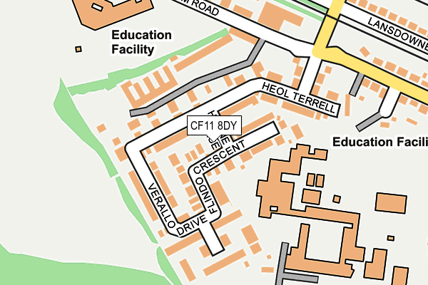
CF11 8DY lies on Herne Place in Canton, Cardiff. CF11 8DY is located in the Canton electoral ward, within the unitary authority of Cardiff and the Welsh Parliamentary constituency of Cardiff West. The Local Health Board is Cardiff and Vale University and the police force is South Wales. This postcode has been in use since June 2003.


GetTheData
Source: OS OpenMap – Local (Ordnance Survey)
Source: OS VectorMap District (Ordnance Survey)
Licence: Open Government Licence (requires attribution)
| Easting | 315771 |
| Northing | 176123 |
| Latitude | 51.477771 |
| Longitude | -3.214238 |
GetTheData
Source: Open Postcode Geo
Licence: Open Government Licence
| Street | Herne Place |
| Locality | Canton |
| Town/City | Cardiff |
| Country | Wales |
| Postcode District | CF11 |
| ➜ CF11 open data dashboard ➜ See where CF11 is on a map ➜ Where is Cardiff? | |
GetTheData
Source: Land Registry Price Paid Data
Licence: Open Government Licence
Elevation or altitude of CF11 8DY as distance above sea level:
| Metres | Feet | |
|---|---|---|
| Elevation | 10m | 33ft |
Elevation is measured from the approximate centre of the postcode, to the nearest point on an OS contour line from OS Terrain 50, which has contour spacing of ten vertical metres.
➜ How high above sea level am I? Find the elevation of your current position using your device's GPS.
GetTheData
Source: Open Postcode Elevation
Licence: Open Government Licence
| Ward | Canton |
| Constituency | Cardiff West |
GetTheData
Source: ONS Postcode Database
Licence: Open Government Licence
2020 14 DEC £385,000 |
2007 30 NOV £262,500 |
2003 27 JUN £207,950 |
2003 20 JUN £206,950 |
GetTheData
Source: HM Land Registry Price Paid Data
Licence: Contains HM Land Registry data © Crown copyright and database right 2024. This data is licensed under the Open Government Licence v3.0.
| June 2022 | Public order | On or near Norrell Close | 78m |
| June 2022 | Theft from the person | On or near Norrell Close | 78m |
| June 2022 | Vehicle crime | On or near Clos Gedrych | 103m |
| ➜ Herne Place crime map and outcomes | |||
GetTheData
Source: data.police.uk
Licence: Open Government Licence
| Fitzalan School (Broad Street) | Canton | 209m |
| Fitzalan School (Broad Street) | Canton | 219m |
| Lansdowne Road | Canton | 350m |
| Lansdowne Road (Lincoln Street) | Cardiff | 372m |
| Broad Street | Canton | 377m |
| Ninian Park Station | 0.9km |
| Waun-gron Park Station | 1.6km |
| Grangetown (Cardiff) Station | 2km |
GetTheData
Source: NaPTAN
Licence: Open Government Licence
| Percentage of properties with Next Generation Access | 100.0% |
| Percentage of properties with Superfast Broadband | 100.0% |
| Percentage of properties with Ultrafast Broadband | 100.0% |
| Percentage of properties with Full Fibre Broadband | 100.0% |
Superfast Broadband is between 30Mbps and 300Mbps
Ultrafast Broadband is > 300Mbps
| Percentage of properties unable to receive 2Mbps | 0.0% |
| Percentage of properties unable to receive 5Mbps | 0.0% |
| Percentage of properties unable to receive 10Mbps | 0.0% |
| Percentage of properties unable to receive 30Mbps | 0.0% |
GetTheData
Source: Ofcom
Licence: Ofcom Terms of Use (requires attribution)
GetTheData
Source: ONS Postcode Database
Licence: Open Government Licence


➜ Get more ratings from the Food Standards Agency
GetTheData
Source: Food Standards Agency
Licence: FSA terms & conditions
| Last Collection | |||
|---|---|---|---|
| Location | Mon-Fri | Sat | Distance |
| Canton Post Office | 17:30 | 12:00 | 753m |
| Penarth Road Post Office | 17:30 | 13:15 | 761m |
| Leckwith Road Post Office | 17:30 | 12:00 | 781m |
GetTheData
Source: Dracos
Licence: Creative Commons Attribution-ShareAlike
| School | Phase of Education | Distance |
|---|---|---|
| Fitzalan High School Lawrenny Avenue, Leckwith, Cardiff, CF11 8XB | Not applicable | 106m |
| Ysgol Gymraeg Treganna Sanatorium Road, Canton, Cardiff, CF11 8DG | Not applicable | 249m |
| Ysgol Gymraeg Pwll Coch Adjacent To Fitzalan High, Lawrenny Avenue, Leckwith, Cardiff, CF11 8BR | Not applicable | 368m |
GetTheData
Source: Edubase
Licence: Open Government Licence
The below table lists the International Territorial Level (ITL) codes (formerly Nomenclature of Territorial Units for Statistics (NUTS) codes) and Local Administrative Units (LAU) codes for CF11 8DY:
| ITL 1 Code | Name |
|---|---|
| TLL | Wales |
| ITL 2 Code | Name |
| TLL2 | East Wales |
| ITL 3 Code | Name |
| TLL22 | Cardiff and Vale of Glamorgan |
| LAU 1 Code | Name |
| W06000015 | Cardiff |
GetTheData
Source: ONS Postcode Directory
Licence: Open Government Licence
The below table lists the Census Output Area (OA), Lower Layer Super Output Area (LSOA), and Middle Layer Super Output Area (MSOA) for CF11 8DY:
| Code | Name | |
|---|---|---|
| OA | W00010140 | |
| LSOA | W01001709 | Cardiff 040A |
| MSOA | W02000406 | Cardiff 040 |
GetTheData
Source: ONS Postcode Directory
Licence: Open Government Licence
| CF11 8DX | Flindo Crescent | 31m |
| CF11 8BF | Heol Terrell | 64m |
| CF11 8DW | Norrell Close | 75m |
| CF11 8DT | Verallo Drive | 95m |
| CF11 8DU | Clos Gedrych | 118m |
| CF11 8DZ | Clos Halket | 169m |
| CF11 8FS | Lansdowne Avenue West | 275m |
| CF11 8BW | Broad Street | 308m |
| CF11 8PN | Sanatorium Road | 334m |
| CF5 1JQ | Lansdowne Road | 352m |
GetTheData
Source: Open Postcode Geo; Land Registry Price Paid Data
Licence: Open Government Licence