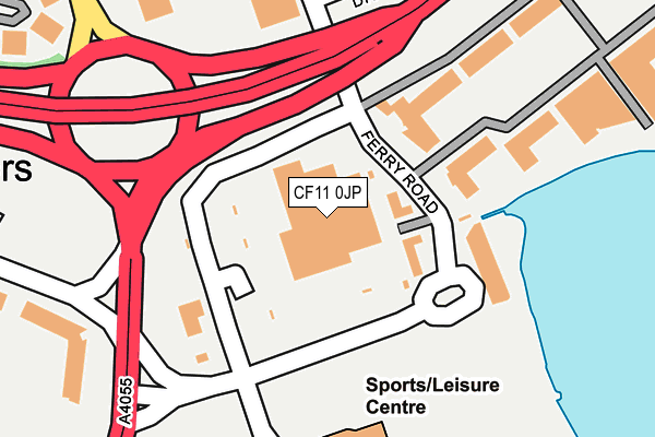
CF11 0JP is located in the Grangetown electoral ward, within the unitary authority of Cardiff and the Welsh Parliamentary constituency of Cardiff South and Penarth. The Local Health Board is Cardiff and Vale University and the police force is South Wales. This postcode has been in use since March 2007.


GetTheData
Source: OS OpenMap – Local (Ordnance Survey)
Source: OS VectorMap District (Ordnance Survey)
Licence: Open Government Licence (requires attribution)
| Easting | 317816 |
| Northing | 173300 |
| Latitude | 51.452695 |
| Longitude | -3.184149 |
GetTheData
Source: Open Postcode Geo
Licence: Open Government Licence
| Country | Wales |
| Postcode District | CF11 |
| ➜ CF11 open data dashboard ➜ See where CF11 is on a map ➜ Where is Penarth? | |
GetTheData
Source: Land Registry Price Paid Data
Licence: Open Government Licence
Elevation or altitude of CF11 0JP as distance above sea level:
| Metres | Feet | |
|---|---|---|
| Elevation | 10m | 33ft |
Elevation is measured from the approximate centre of the postcode, to the nearest point on an OS contour line from OS Terrain 50, which has contour spacing of ten vertical metres.
➜ How high above sea level am I? Find the elevation of your current position using your device's GPS.
GetTheData
Source: Open Postcode Elevation
Licence: Open Government Licence
| Ward | Grangetown |
| Constituency | Cardiff South And Penarth |
GetTheData
Source: ONS Postcode Database
Licence: Open Government Licence
| January 2024 | Vehicle crime | On or near Cory Place | 356m |
| January 2024 | Violence and sexual offences | On or near Cory Place | 356m |
| December 2023 | Violence and sexual offences | On or near Cory Place | 356m |
| ➜ Get more crime data in our Crime section | |||
GetTheData
Source: data.police.uk
Licence: Open Government Licence
| Celtic Gateway (Dunleavy Drive) | Penarth Moors | 128m |
| International Drive | Cardiff Bay | 176m |
| International Drive | Cardiff Bay | 195m |
| O'leary Drive (Ferry Road) | Grangetown | 219m |
| Prospect Place (Ferry Road) | Cardiff Bay | 262m |
| Cogan Station | 0.8km |
| Dingle Road Station | 1.4km |
| Grangetown (Cardiff) Station | 1.7km |
GetTheData
Source: NaPTAN
Licence: Open Government Licence
GetTheData
Source: ONS Postcode Database
Licence: Open Government Licence


➜ Get more ratings from the Food Standards Agency
GetTheData
Source: Food Standards Agency
Licence: FSA terms & conditions
| Last Collection | |||
|---|---|---|---|
| Location | Mon-Fri | Sat | Distance |
| Dochdwy Road | 17:00 | 11:30 | 838m |
| Penarth Marina | 16:00 | 12:00 | 932m |
| Llandough Post Office | 17:00 | 12:00 | 936m |
GetTheData
Source: Dracos
Licence: Creative Commons Attribution-ShareAlike
| School | Phase of Education | Distance |
|---|---|---|
| Llandough Primary Dochdwy Road, Llandough, Penarth, CF64 2QD | Not applicable | 965m |
| Grangetown Nursery School Avondale Road, Grangetown, Cardiff, CF1 7DW | Not applicable | 1.1km |
| Cogan Primary School Pill Street, Cogan, Nr. Penarth, Vale of Glamorgan, CF64 2JS | Not applicable | 1.1km |
GetTheData
Source: Edubase
Licence: Open Government Licence
The below table lists the International Territorial Level (ITL) codes (formerly Nomenclature of Territorial Units for Statistics (NUTS) codes) and Local Administrative Units (LAU) codes for CF11 0JP:
| ITL 1 Code | Name |
|---|---|
| TLL | Wales |
| ITL 2 Code | Name |
| TLL2 | East Wales |
| ITL 3 Code | Name |
| TLL22 | Cardiff and Vale of Glamorgan |
| LAU 1 Code | Name |
| W06000015 | Cardiff |
GetTheData
Source: ONS Postcode Directory
Licence: Open Government Licence
The below table lists the Census Output Area (OA), Lower Layer Super Output Area (LSOA), and Middle Layer Super Output Area (MSOA) for CF11 0JP:
| Code | Name | |
|---|---|---|
| OA | W00010149 | |
| LSOA | W01001947 | Cardiff 048E |
| MSOA | W02000422 | Cardiff 048 |
GetTheData
Source: ONS Postcode Directory
Licence: Open Government Licence
| CF11 0JB | Ferry Court | 235m |
| CF11 0AP | Burford Gardens | 255m |
| CF11 0JD | Ferry Court | 266m |
| CF11 7EB | Oleary Drive | 267m |
| CF11 0JT | Ferry Court | 269m |
| CF11 0JU | Ferry Road | 281m |
| CF11 0JE | Ferry Court | 321m |
| CF11 0JQ | Ferry Court | 333m |
| CF11 7QB | Cory Place | 371m |
| CF11 0JF | Ferry Court | 376m |
GetTheData
Source: Open Postcode Geo; Land Registry Price Paid Data
Licence: Open Government Licence