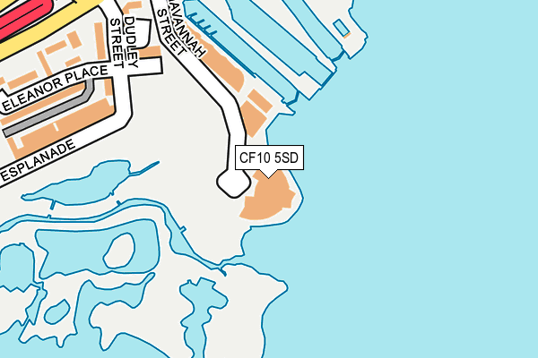
CF10 5SD is located in the Butetown electoral ward, within the unitary authority of Cardiff and the Welsh Parliamentary constituency of Cardiff South and Penarth. The Local Health Board is Cardiff and Vale University and the police force is South Wales. This postcode has been in use since June 1999.


GetTheData
Source: OS OpenMap – Local (Ordnance Survey)
Source: OS VectorMap District (Ordnance Survey)
Licence: Open Government Licence (requires attribution)
| Easting | 319019 |
| Northing | 174155 |
| Latitude | 51.460555 |
| Longitude | -3.167027 |
GetTheData
Source: Open Postcode Geo
Licence: Open Government Licence
| Country | Wales |
| Postcode District | CF10 |
| ➜ CF10 open data dashboard ➜ See where CF10 is on a map ➜ Where is Cardiff? | |
GetTheData
Source: Land Registry Price Paid Data
Licence: Open Government Licence
Elevation or altitude of CF10 5SD as distance above sea level:
| Metres | Feet | |
|---|---|---|
| Elevation | 0m | 0ft |
Elevation is measured from the approximate centre of the postcode, to the nearest point on an OS contour line from OS Terrain 50, which has contour spacing of ten vertical metres.
➜ How high above sea level am I? Find the elevation of your current position using your device's GPS.
GetTheData
Source: Open Postcode Elevation
Licence: Open Government Licence
| Ward | Butetown |
| Constituency | Cardiff South And Penarth |
GetTheData
Source: ONS Postcode Database
Licence: Open Government Licence
| June 2022 | Other theft | On or near Parking Area | 102m |
| June 2022 | Violence and sexual offences | On or near Dudley Street | 243m |
| June 2022 | Bicycle theft | On or near Stuart Place | 269m |
| ➜ Get more crime data in our Crime section | |||
GetTheData
Source: data.police.uk
Licence: Open Government Licence
| Stuart Street | Cardiff Bay | 278m |
| Mermaid Quay Waterbus (Stuart Street) | Cardiff Bay | 309m |
| Mermaid Quay (New George Street) | Cardiff Bay | 309m |
| Adelaide Street | Cardiff Bay | 388m |
| Mermaid Quay (New George Street) | Cardiff Bay | 401m |
| Cardiff Bay Station | 0.7km |
| Grangetown (Cardiff) Station | 1.8km |
| Cardiff Central Station | 1.9km |
GetTheData
Source: NaPTAN
Licence: Open Government Licence
GetTheData
Source: ONS Postcode Database
Licence: Open Government Licence


➜ Get more ratings from the Food Standards Agency
GetTheData
Source: Food Standards Agency
Licence: FSA terms & conditions
| Last Collection | |||
|---|---|---|---|
| Location | Mon-Fri | Sat | Distance |
| Dudley Street | 18:30 | 11:30 | 215m |
| Channel View Road | 17:30 | 11:30 | 235m |
| James Street | 18:30 | 11:30 | 441m |
GetTheData
Source: Dracos
Licence: Creative Commons Attribution-ShareAlike
| School | Phase of Education | Distance |
|---|---|---|
| Mount Stuart Primary Adelaide Street, Butetown, Cardiff, CF10 5BS | Not applicable | 352m |
| Ysgol Gynradd Gymraeg Hamadryad Hamadryad Road, Caerdydd, CF10 5UY | Not applicable | 613m |
| Grangetown Nursery School Avondale Road, Grangetown, Cardiff, CF1 7DW | Not applicable | 1.2km |
GetTheData
Source: Edubase
Licence: Open Government Licence
The below table lists the International Territorial Level (ITL) codes (formerly Nomenclature of Territorial Units for Statistics (NUTS) codes) and Local Administrative Units (LAU) codes for CF10 5SD:
| ITL 1 Code | Name |
|---|---|
| TLL | Wales |
| ITL 2 Code | Name |
| TLL2 | East Wales |
| ITL 3 Code | Name |
| TLL22 | Cardiff and Vale of Glamorgan |
| LAU 1 Code | Name |
| W06000015 | Cardiff |
GetTheData
Source: ONS Postcode Directory
Licence: Open Government Licence
The below table lists the Census Output Area (OA), Lower Layer Super Output Area (LSOA), and Middle Layer Super Output Area (MSOA) for CF10 5SD:
| Code | Name | |
|---|---|---|
| OA | W00010127 | |
| LSOA | W01001943 | Cardiff 048B |
| MSOA | W02000422 | Cardiff 048 |
GetTheData
Source: ONS Postcode Directory
Licence: Open Government Licence
| CF10 5SG | Havannah Street | 71m |
| CF10 5SF | Havannah Street | 157m |
| CF10 5BD | Bute Esplanade | 204m |
| CF10 5BE | Windsor Terrace | 215m |
| CF10 5BL | Dudley Street | 247m |
| CF10 5BQ | Dudley Court | 248m |
| CF10 5BW | Stuart Street | 256m |
| CF10 5BJ | Eleanor Place | 295m |
| CF10 5BZ | Mermaid Quay | 341m |
| CF10 5BG | Windsor Esplanade | 350m |
GetTheData
Source: Open Postcode Geo; Land Registry Price Paid Data
Licence: Open Government Licence