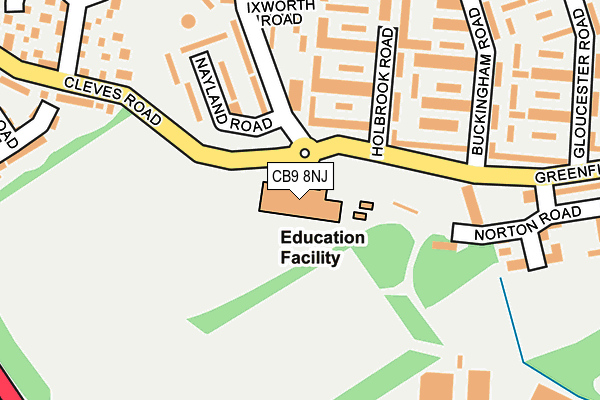
CB9 8NJ is located in the Haverhill South electoral ward, within the local authority district of West Suffolk and the English Parliamentary constituency of West Suffolk. The Sub Integrated Care Board (ICB) Location is NHS Suffolk and North East Essex ICB - 07K and the police force is Suffolk. This postcode has been in use since May 2011.


GetTheData
Source: OS OpenMap – Local (Ordnance Survey)
Source: OS VectorMap District (Ordnance Survey)
Licence: Open Government Licence (requires attribution)
| Easting | 566249 |
| Northing | 244791 |
| Latitude | 52.076522 |
| Longitude | 0.424501 |
GetTheData
Source: Open Postcode Geo
Licence: Open Government Licence
| Country | England |
| Postcode District | CB9 |
➜ See where CB9 is on a map ➜ Where is Haverhill? | |
GetTheData
Source: Land Registry Price Paid Data
Licence: Open Government Licence
Elevation or altitude of CB9 8NJ as distance above sea level:
| Metres | Feet | |
|---|---|---|
| Elevation | 100m | 328ft |
Elevation is measured from the approximate centre of the postcode, to the nearest point on an OS contour line from OS Terrain 50, which has contour spacing of ten vertical metres.
➜ How high above sea level am I? Find the elevation of your current position using your device's GPS.
GetTheData
Source: Open Postcode Elevation
Licence: Open Government Licence
| Ward | Haverhill South |
| Constituency | West Suffolk |
GetTheData
Source: ONS Postcode Database
Licence: Open Government Licence
| Nayland Road (Greenfields Way) | Haverhill | 161m |
| Nayland Road (Greenfields Way) | Haverhill | 170m |
| Headland Avenue (Greenfields Way) | Haverhill | 289m |
| Gloucester Road (Greenfields Way) | Haverhill | 289m |
| Headland Avenue (Greenfields Way) | Haverhill | 294m |
GetTheData
Source: NaPTAN
Licence: Open Government Licence
GetTheData
Source: ONS Postcode Database
Licence: Open Government Licence


➜ Get more ratings from the Food Standards Agency
GetTheData
Source: Food Standards Agency
Licence: FSA terms & conditions
| Last Collection | |||
|---|---|---|---|
| Location | Mon-Fri | Sat | Distance |
| Clements Post Office | 17:45 | 11:45 | 268m |
| Abercorn Court | 17:45 | 11:30 | 569m |
| North Avenue | 17:45 | 11:30 | 647m |
GetTheData
Source: Dracos
Licence: Creative Commons Attribution-ShareAlike
The below table lists the International Territorial Level (ITL) codes (formerly Nomenclature of Territorial Units for Statistics (NUTS) codes) and Local Administrative Units (LAU) codes for CB9 8NJ:
| ITL 1 Code | Name |
|---|---|
| TLH | East |
| ITL 2 Code | Name |
| TLH1 | East Anglia |
| ITL 3 Code | Name |
| TLH14 | Suffolk CC |
| LAU 1 Code | Name |
| E07000245 | West Suffolk |
GetTheData
Source: ONS Postcode Directory
Licence: Open Government Licence
The below table lists the Census Output Area (OA), Lower Layer Super Output Area (LSOA), and Middle Layer Super Output Area (MSOA) for CB9 8NJ:
| Code | Name | |
|---|---|---|
| OA | E00169953 | |
| LSOA | E01030115 | St Edmundsbury 013A |
| MSOA | E02006285 | St Edmundsbury 013 |
GetTheData
Source: ONS Postcode Directory
Licence: Open Government Licence
| CB9 8ND | Cavendish Court | 101m |
| CB9 8NE | Covehite Court | 150m |
| CB9 8NA | Ladygate | 156m |
| CB9 8NB | Butley Court | 167m |
| CB9 8NF | Norton Road | 206m |
| CB9 8LX | Fritton Court | 223m |
| CB9 8LY | Aldham Court | 228m |
| CB9 8LZ | Blaxhall Court | 238m |
| CB9 8LR | Greenfields Way | 244m |
| CB9 9QU | Cleves Road | 263m |
GetTheData
Source: Open Postcode Geo; Land Registry Price Paid Data
Licence: Open Government Licence