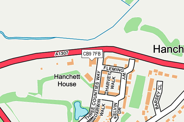
CB9 7FB lies on Three Counties Way in Withersfield, Haverhill. CB9 7FB is located in the Withersfield electoral ward, within the local authority district of West Suffolk and the English Parliamentary constituency of West Suffolk. The Sub Integrated Care Board (ICB) Location is NHS Suffolk and North East Essex ICB - 07K and the police force is Suffolk. This postcode has been in use since February 2014.


GetTheData
Source: OS OpenMap – Local (Ordnance Survey)
Source: OS VectorMap District (Ordnance Survey)
Licence: Open Government Licence (requires attribution)
| Easting | 564822 |
| Northing | 246508 |
| Latitude | 52.092384 |
| Longitude | 0.404557 |
GetTheData
Source: Open Postcode Geo
Licence: Open Government Licence
| Street | Three Counties Way |
| Locality | Withersfield |
| Town/City | Haverhill |
| Country | England |
| Postcode District | CB9 |
| ➜ CB9 open data dashboard ➜ See where CB9 is on a map ➜ Where is Haverhill? | |
GetTheData
Source: Land Registry Price Paid Data
Licence: Open Government Licence
Elevation or altitude of CB9 7FB as distance above sea level:
| Metres | Feet | |
|---|---|---|
| Elevation | 80m | 262ft |
Elevation is measured from the approximate centre of the postcode, to the nearest point on an OS contour line from OS Terrain 50, which has contour spacing of ten vertical metres.
➜ How high above sea level am I? Find the elevation of your current position using your device's GPS.
GetTheData
Source: Open Postcode Elevation
Licence: Open Government Licence
| Ward | Withersfield |
| Constituency | West Suffolk |
GetTheData
Source: ONS Postcode Database
Licence: Open Government Licence
| June 2022 | Violence and sexual offences | On or near Shardlow Close | 424m |
| April 2022 | Anti-social behaviour | On or near Barsey Close | 226m |
| April 2022 | Violence and sexual offences | On or near Barsey Close | 226m |
| ➜ Get more crime data in our Crime section | |||
GetTheData
Source: data.police.uk
Licence: Open Government Licence
| Research Park | Haverhill | 159m |
| Research Park | Haverhill | 161m |
| Shardlow Close (Haycock Drive) | Haverhill | 370m |
| Shardlow Close (Haycock Drive) | Haverhill | 388m |
| Notley Drive (Haycocks Road) | Haverhill | 445m |
GetTheData
Source: NaPTAN
Licence: Open Government Licence
GetTheData
Source: ONS Postcode Database
Licence: Open Government Licence


➜ Get more ratings from the Food Standards Agency
GetTheData
Source: Food Standards Agency
Licence: FSA terms & conditions
| Last Collection | |||
|---|---|---|---|
| Location | Mon-Fri | Sat | Distance |
| Notley Drive | 17:45 | 11:30 | 515m |
| Sainsburys | 17:45 | 11:30 | 545m |
| Melbourne Bridge | 17:00 | 08:45 | 927m |
GetTheData
Source: Dracos
Licence: Creative Commons Attribution-ShareAlike
| Facility | Distance |
|---|---|
| Parkway Middle School (Closed) Park Road, Haverhill Grass Pitches, Sports Hall | 1.2km |
| Haverhill And District Rfc School Lane, School Lane, Haverhill Grass Pitches | 1.4km |
| Castle Hill Community Middle School (Closed) School Lane, Haverhill Grass Pitches, Sports Hall | 1.5km |
GetTheData
Source: Active Places
Licence: Open Government Licence
| School | Phase of Education | Distance |
|---|---|---|
| St Felix Roman Catholic Primary School, Haverhill School Lane, HAVERHILL, CB9 9DE | Primary | 1.4km |
| Burton End Primary Academy School Lane, Burton End, Haverhill, CB9 9DE | Primary | 1.6km |
| Castle Manor Academy Eastern Avenue, Haverhill, CB9 9JE | Secondary | 1.8km |
GetTheData
Source: Edubase
Licence: Open Government Licence
The below table lists the International Territorial Level (ITL) codes (formerly Nomenclature of Territorial Units for Statistics (NUTS) codes) and Local Administrative Units (LAU) codes for CB9 7FB:
| ITL 1 Code | Name |
|---|---|
| TLH | East |
| ITL 2 Code | Name |
| TLH1 | East Anglia |
| ITL 3 Code | Name |
| TLH14 | Suffolk CC |
| LAU 1 Code | Name |
| E07000245 | West Suffolk |
GetTheData
Source: ONS Postcode Directory
Licence: Open Government Licence
The below table lists the Census Output Area (OA), Lower Layer Super Output Area (LSOA), and Middle Layer Super Output Area (MSOA) for CB9 7FB:
| Code | Name | |
|---|---|---|
| OA | E00153722 | |
| LSOA | E01030151 | St Edmundsbury 011C |
| MSOA | E02006283 | St Edmundsbury 011 |
GetTheData
Source: ONS Postcode Directory
Licence: Open Government Licence
| CB9 7SS | Harvey Walk | 40m |
| CB9 7SQ | Fleming Way | 78m |
| CB9 7QE | Watson Place | 122m |
| CB9 7SX | Kelvin Drive | 142m |
| CB9 7ST | Darwin Walk | 163m |
| CB9 7TS | Barsey Close | 195m |
| CB9 7GE | Hanchett End | 248m |
| CB9 7RP | Hanchett End | 297m |
| CB9 7FH | Lane End | 314m |
| CB9 7FJ | Langham Way | 358m |
GetTheData
Source: Open Postcode Geo; Land Registry Price Paid Data
Licence: Open Government Licence