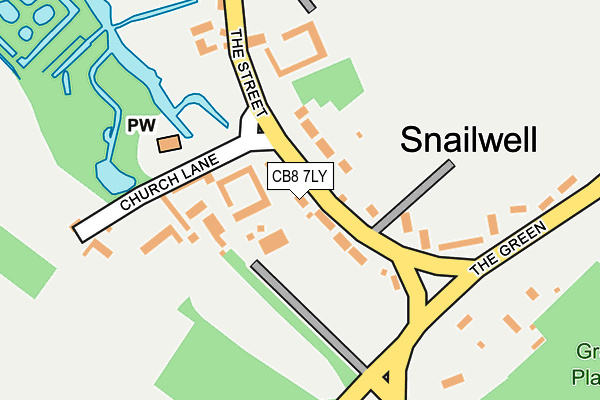
CB8 7LY lies on The Street in Snailwell, Newmarket. CB8 7LY is located in the Fordham & Isleham electoral ward, within the local authority district of East Cambridgeshire and the English Parliamentary constituency of South East Cambridgeshire. The Sub Integrated Care Board (ICB) Location is NHS Cambridgeshire and Peterborough ICB - 06H and the police force is Cambridgeshire. This postcode has been in use since January 1980.


GetTheData
Source: OS OpenMap – Local (Ordnance Survey)
Source: OS VectorMap District (Ordnance Survey)
Licence: Open Government Licence (requires attribution)
| Easting | 564354 |
| Northing | 267519 |
| Latitude | 52.281242 |
| Longitude | 0.407880 |
GetTheData
Source: Open Postcode Geo
Licence: Open Government Licence
| Street | The Street |
| Locality | Snailwell |
| Town/City | Newmarket |
| Country | England |
| Postcode District | CB8 |
| ➜ CB8 open data dashboard ➜ See where CB8 is on a map ➜ Where is Snailwell? | |
GetTheData
Source: Land Registry Price Paid Data
Licence: Open Government Licence
Elevation or altitude of CB8 7LY as distance above sea level:
| Metres | Feet | |
|---|---|---|
| Elevation | 20m | 66ft |
Elevation is measured from the approximate centre of the postcode, to the nearest point on an OS contour line from OS Terrain 50, which has contour spacing of ten vertical metres.
➜ How high above sea level am I? Find the elevation of your current position using your device's GPS.
GetTheData
Source: Open Postcode Elevation
Licence: Open Government Licence
| Ward | Fordham & Isleham |
| Constituency | South East Cambridgeshire |
GetTheData
Source: ONS Postcode Database
Licence: Open Government Licence
| March 2022 | Violence and sexual offences | On or near The Street | 132m |
| February 2022 | Violence and sexual offences | On or near The Green | 190m |
| December 2021 | Other theft | On or near Church Lane | 125m |
| ➜ Get more crime data in our Crime section | |||
GetTheData
Source: data.police.uk
Licence: Open Government Licence
| Church Lane (The Street) | Snailwell | 79m |
| Green (Short Road) | Snailwell | 174m |
| Green (Short Road) | Snailwell | 180m |
| Lynx Business Park (Snailwell Road) | Snailwell | 945m |
| Lynx Business Park (Snailwell Road) | Snailwell | 949m |
| Newmarket Station | 4.8km |
GetTheData
Source: NaPTAN
Licence: Open Government Licence
| Percentage of properties with Next Generation Access | 100.0% |
| Percentage of properties with Superfast Broadband | 100.0% |
| Percentage of properties with Ultrafast Broadband | 0.0% |
| Percentage of properties with Full Fibre Broadband | 0.0% |
Superfast Broadband is between 30Mbps and 300Mbps
Ultrafast Broadband is > 300Mbps
| Percentage of properties unable to receive 2Mbps | 0.0% |
| Percentage of properties unable to receive 5Mbps | 0.0% |
| Percentage of properties unable to receive 10Mbps | 0.0% |
| Percentage of properties unable to receive 30Mbps | 0.0% |
GetTheData
Source: Ofcom
Licence: Ofcom Terms of Use (requires attribution)
GetTheData
Source: ONS Postcode Database
Licence: Open Government Licence


➜ Get more ratings from the Food Standards Agency
GetTheData
Source: Food Standards Agency
Licence: FSA terms & conditions
| Last Collection | |||
|---|---|---|---|
| Location | Mon-Fri | Sat | Distance |
| Snailwell Village | 16:15 | 08:00 | 164m |
| Fordham Bridge | 16:45 | 08:00 | 966m |
| Landwade Village | 16:00 | 08:45 | 2,035m |
GetTheData
Source: Dracos
Licence: Creative Commons Attribution-ShareAlike
| Facility | Distance |
|---|---|
| Lynx Fitness (Newmarket) Fordham Road, Fordham Road, Snailwell Health and Fitness Gym | 942m |
| Studlands Park Sports & Social Club Pinza Close, Newmarket Grass Pitches | 2.3km |
| Snailwell Road Snailwell Road, Newmarket Grass Pitches | 2.4km |
GetTheData
Source: Active Places
Licence: Open Government Licence
| School | Phase of Education | Distance |
|---|---|---|
| Cambian Dunbroch School Fordham Road, Fordham, Newmarket, Suffolk, CB8 7LG | Not applicable | 965m |
| Laureate Community Academy Exning Road, Newmarket, CB8 0AN | Primary | 3km |
| Exning Primary School Oxford Street, Exning, Newmarket, CB8 7EW | Primary | 3.2km |
GetTheData
Source: Edubase
Licence: Open Government Licence
The below table lists the International Territorial Level (ITL) codes (formerly Nomenclature of Territorial Units for Statistics (NUTS) codes) and Local Administrative Units (LAU) codes for CB8 7LY:
| ITL 1 Code | Name |
|---|---|
| TLH | East |
| ITL 2 Code | Name |
| TLH1 | East Anglia |
| ITL 3 Code | Name |
| TLH12 | Cambridgeshire CC |
| LAU 1 Code | Name |
| E07000009 | East Cambridgeshire |
GetTheData
Source: ONS Postcode Directory
Licence: Open Government Licence
The below table lists the Census Output Area (OA), Lower Layer Super Output Area (LSOA), and Middle Layer Super Output Area (MSOA) for CB8 7LY:
| Code | Name | |
|---|---|---|
| OA | E00090983 | |
| LSOA | E01018035 | East Cambridgeshire 007B |
| MSOA | E02003738 | East Cambridgeshire 007 |
GetTheData
Source: ONS Postcode Directory
Licence: Open Government Licence
| CB8 7LU | The Street | 66m |
| CB8 7LX | The Street | 138m |
| CB8 7LZ | Church Lane | 151m |
| CB8 7LT | The Green | 180m |
| CB8 7LS | The Green | 204m |
| CB8 7LG | Fordham Road | 1020m |
| CB8 7NB | Fordham Road | 1049m |
| CB8 7LN | Newmarket Road | 1428m |
| CB8 7LW | Snailwell Road | 1673m |
| CB7 5QB | Snailwell Road | 1764m |
GetTheData
Source: Open Postcode Geo; Land Registry Price Paid Data
Licence: Open Government Licence