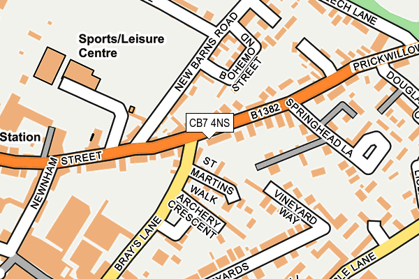
CB7 4NS lies on Prickwillow Road in Ely. CB7 4NS is located in the Ely East electoral ward, within the local authority district of East Cambridgeshire and the English Parliamentary constituency of South East Cambridgeshire. The Sub Integrated Care Board (ICB) Location is NHS Cambridgeshire and Peterborough ICB - 06H and the police force is Cambridgeshire. This postcode has been in use since January 1980.


GetTheData
Source: OS OpenMap – Local (Ordnance Survey)
Source: OS VectorMap District (Ordnance Survey)
Licence: Open Government Licence (requires attribution)
| Easting | 554493 |
| Northing | 280565 |
| Latitude | 52.401294 |
| Longitude | 0.269446 |
GetTheData
Source: Open Postcode Geo
Licence: Open Government Licence
| Street | Prickwillow Road |
| Town/City | Ely |
| Country | England |
| Postcode District | CB7 |
| ➜ CB7 open data dashboard ➜ See where CB7 is on a map ➜ Where is Ely? | |
GetTheData
Source: Land Registry Price Paid Data
Licence: Open Government Licence
Elevation or altitude of CB7 4NS as distance above sea level:
| Metres | Feet | |
|---|---|---|
| Elevation | 20m | 66ft |
Elevation is measured from the approximate centre of the postcode, to the nearest point on an OS contour line from OS Terrain 50, which has contour spacing of ten vertical metres.
➜ How high above sea level am I? Find the elevation of your current position using your device's GPS.
GetTheData
Source: Open Postcode Elevation
Licence: Open Government Licence
| Ward | Ely East |
| Constituency | South East Cambridgeshire |
GetTheData
Source: ONS Postcode Database
Licence: Open Government Licence
14, PRICKWILLOW ROAD, ELY, CB7 4NS 1995 14 SEP £74,000 |
GetTheData
Source: HM Land Registry Price Paid Data
Licence: Contains HM Land Registry data © Crown copyright and database right 2024. This data is licensed under the Open Government Licence v3.0.
| January 2024 | Violence and sexual offences | On or near Parking Area | 139m |
| January 2024 | Shoplifting | On or near Parking Area | 139m |
| January 2024 | Shoplifting | On or near Parking Area | 139m |
| ➜ Get more crime data in our Crime section | |||
GetTheData
Source: data.police.uk
Licence: Open Government Licence
| Springhead Lane (Prickwillow Road) | Ely | 32m |
| Springhead Lane (Prickwillow Road) | Ely | 125m |
| Waitrose (Bray's Lane) | Ely | 173m |
| Bell Holt (Lisle Lane) | Ely | 266m |
| Beech Lane | Ely | 269m |
| Ely Station | 1.1km |
GetTheData
Source: NaPTAN
Licence: Open Government Licence
GetTheData
Source: ONS Postcode Database
Licence: Open Government Licence


➜ Get more ratings from the Food Standards Agency
GetTheData
Source: Food Standards Agency
Licence: FSA terms & conditions
| Last Collection | |||
|---|---|---|---|
| Location | Mon-Fri | Sat | Distance |
| Prickwillow Road | 17:30 | 11:45 | 102m |
| New Barns Road | 17:30 | 12:00 | 136m |
| Market Place | 17:30 | 12:30 | 289m |
GetTheData
Source: Dracos
Licence: Creative Commons Attribution-ShareAlike
| Facility | Distance |
|---|---|
| The Paradise Centre Newnham Street, Ely Sports Hall, Health and Fitness Gym, Grass Pitches, Studio, Squash Courts | 205m |
| Paradise Pools (Closed) Newnham Street, Ely Swimming Pool | 205m |
| Atrium Club (Ely) Newnham Street, Ely Health and Fitness Gym, Swimming Pool, Studio | 221m |
GetTheData
Source: Active Places
Licence: Open Government Licence
| School | Phase of Education | Distance |
|---|---|---|
| King's Ely Barton Road, Ely, CB7 4DB | Not applicable | 705m |
| Highfield Ely Academy Downham Road, Ely, CB6 1BD | Not applicable | 749m |
| Active Learning Trust Linc 19 - 25 Downham Road, Ely, CB6 1BD | Not applicable | 769m |
GetTheData
Source: Edubase
Licence: Open Government Licence
The below table lists the International Territorial Level (ITL) codes (formerly Nomenclature of Territorial Units for Statistics (NUTS) codes) and Local Administrative Units (LAU) codes for CB7 4NS:
| ITL 1 Code | Name |
|---|---|
| TLH | East |
| ITL 2 Code | Name |
| TLH1 | East Anglia |
| ITL 3 Code | Name |
| TLH12 | Cambridgeshire CC |
| LAU 1 Code | Name |
| E07000009 | East Cambridgeshire |
GetTheData
Source: ONS Postcode Directory
Licence: Open Government Licence
The below table lists the Census Output Area (OA), Lower Layer Super Output Area (LSOA), and Middle Layer Super Output Area (MSOA) for CB7 4NS:
| Code | Name | |
|---|---|---|
| OA | E00090920 | |
| LSOA | E01018025 | East Cambridgeshire 004B |
| MSOA | E02003735 | East Cambridgeshire 004 |
GetTheData
Source: ONS Postcode Directory
Licence: Open Government Licence
| CB7 4QJ | Brays Lane | 67m |
| CB7 4QP | Prickwillow Road | 72m |
| CB7 4QF | St Martins Walk | 72m |
| CB7 4PN | New Barns Road | 75m |
| CB7 4QR | Prickwillow Road | 111m |
| CB7 4PP | Bohemond Street | 125m |
| CB7 4QT | Prickwillow Road | 140m |
| CB7 4QQ | Vineyard Way | 144m |
| CB7 4PQ | Newnham Street | 179m |
| CB7 4QG | The Vineyards | 199m |
GetTheData
Source: Open Postcode Geo; Land Registry Price Paid Data
Licence: Open Government Licence