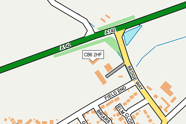
CB6 2HF is located in the Stretham electoral ward, within the local authority district of East Cambridgeshire and the English Parliamentary constituency of South East Cambridgeshire. The Sub Integrated Care Board (ICB) Location is NHS Cambridgeshire and Peterborough ICB - 06H and the police force is Cambridgeshire. This postcode has been in use since September 2003.


GetTheData
Source: OS OpenMap – Local (Ordnance Survey)
Source: OS VectorMap District (Ordnance Survey)
Licence: Open Government Licence (requires attribution)
| Easting | 550039 |
| Northing | 279250 |
| Latitude | 52.390719 |
| Longitude | 0.203442 |
GetTheData
Source: Open Postcode Geo
Licence: Open Government Licence
| Country | England |
| Postcode District | CB6 |
| ➜ CB6 open data dashboard ➜ See where CB6 is on a map ➜ Where is Witchford? | |
GetTheData
Source: Land Registry Price Paid Data
Licence: Open Government Licence
Elevation or altitude of CB6 2HF as distance above sea level:
| Metres | Feet | |
|---|---|---|
| Elevation | 10m | 33ft |
Elevation is measured from the approximate centre of the postcode, to the nearest point on an OS contour line from OS Terrain 50, which has contour spacing of ten vertical metres.
➜ How high above sea level am I? Find the elevation of your current position using your device's GPS.
GetTheData
Source: Open Postcode Elevation
Licence: Open Government Licence
| Ward | Stretham |
| Constituency | South East Cambridgeshire |
GetTheData
Source: ONS Postcode Database
Licence: Open Government Licence
| January 2024 | Violence and sexual offences | On or near Orton Drive | 487m |
| September 2023 | Criminal damage and arson | On or near Clover End | 382m |
| August 2023 | Violence and sexual offences | On or near Clover End | 382m |
| ➜ Get more crime data in our Crime section | |||
GetTheData
Source: data.police.uk
Licence: Open Government Licence
| Clover End (Main Street) | Witchford | 430m |
| Clover End (Main Street) | Witchford | 442m |
| Church View (Main Street) | Witchford | 500m |
| Church View (Main Street) | Witchford | 522m |
| Granta Close (Main Street) | Witchford | 619m |
| Ely Station | 4.3km |
GetTheData
Source: NaPTAN
Licence: Open Government Licence
GetTheData
Source: ONS Postcode Database
Licence: Open Government Licence


➜ Get more ratings from the Food Standards Agency
GetTheData
Source: Food Standards Agency
Licence: FSA terms & conditions
| Last Collection | |||
|---|---|---|---|
| Location | Mon-Fri | Sat | Distance |
| Common Road | 17:15 | 10:15 | 281m |
| Witchford Post Office | 17:00 | 10:15 | 424m |
| Main Street West | 17:00 | 10:15 | 687m |
GetTheData
Source: Dracos
Licence: Creative Commons Attribution-ShareAlike
| Facility | Distance |
|---|---|
| Rackham Church Of England Primary School Main Street, Witchford, Ely Grass Pitches, Swimming Pool, Artificial Grass Pitch | 548m |
| Witchford Village College Manor Road, Witchford, Ely Health and Fitness Gym, Sports Hall, Grass Pitches, Artificial Grass Pitch, Studio, Outdoor Tennis Courts | 587m |
| Witchford Playing Field Bedwell Hey Lane, Witchford, Ely Grass Pitches | 1km |
GetTheData
Source: Active Places
Licence: Open Government Licence
| School | Phase of Education | Distance |
|---|---|---|
| The Rackham Church of England Primary School Main Street, Witchford, Ely, CB6 2HQ | Primary | 439m |
| Witchford Village College Manor Road, Witchford, Ely, CB6 2JA | Secondary | 587m |
| Ely St John's Community Primary School St John's Road, Ely, CB6 3BW | Primary | 2.9km |
GetTheData
Source: Edubase
Licence: Open Government Licence
The below table lists the International Territorial Level (ITL) codes (formerly Nomenclature of Territorial Units for Statistics (NUTS) codes) and Local Administrative Units (LAU) codes for CB6 2HF:
| ITL 1 Code | Name |
|---|---|
| TLH | East |
| ITL 2 Code | Name |
| TLH1 | East Anglia |
| ITL 3 Code | Name |
| TLH12 | Cambridgeshire CC |
| LAU 1 Code | Name |
| E07000009 | East Cambridgeshire |
GetTheData
Source: ONS Postcode Directory
Licence: Open Government Licence
The below table lists the Census Output Area (OA), Lower Layer Super Output Area (LSOA), and Middle Layer Super Output Area (MSOA) for CB6 2HF:
| Code | Name | |
|---|---|---|
| OA | E00090997 | |
| LSOA | E01018039 | East Cambridgeshire 005D |
| MSOA | E02003736 | East Cambridgeshire 005 |
GetTheData
Source: ONS Postcode Directory
Licence: Open Government Licence
| CB6 2HY | Common Road | 52m |
| CB6 2JH | Elm Close | 218m |
| CB6 2GA | Briars End | 238m |
| CB6 2XF | Granary End | 256m |
| CB6 2GB | Briars End | 288m |
| CB6 2XB | Victoria Green | 299m |
| CB6 2XE | Field End | 316m |
| CB6 2JP | Briery Fields | 364m |
| CB6 2JX | Cole Close | 382m |
| CB6 2XD | Clover End | 396m |
GetTheData
Source: Open Postcode Geo; Land Registry Price Paid Data
Licence: Open Government Licence