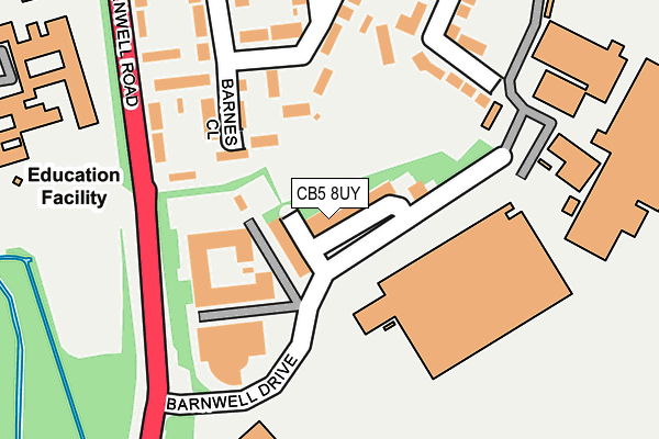
CB5 8UY is located in the Abbey electoral ward, within the local authority district of Cambridge and the English Parliamentary constituency of Cambridge. The Sub Integrated Care Board (ICB) Location is NHS Cambridgeshire and Peterborough ICB - 06H and the police force is Cambridgeshire. This postcode has been in use since October 1985.


GetTheData
Source: OS OpenMap – Local (Ordnance Survey)
Source: OS VectorMap District (Ordnance Survey)
Licence: Open Government Licence (requires attribution)
| Easting | 548102 |
| Northing | 258758 |
| Latitude | 52.207150 |
| Longitude | 0.165996 |
GetTheData
Source: Open Postcode Geo
Licence: Open Government Licence
| Country | England |
| Postcode District | CB5 |
| ➜ CB5 open data dashboard ➜ See where CB5 is on a map ➜ Where is Cambridge? | |
GetTheData
Source: Land Registry Price Paid Data
Licence: Open Government Licence
Elevation or altitude of CB5 8UY as distance above sea level:
| Metres | Feet | |
|---|---|---|
| Elevation | 10m | 33ft |
Elevation is measured from the approximate centre of the postcode, to the nearest point on an OS contour line from OS Terrain 50, which has contour spacing of ten vertical metres.
➜ How high above sea level am I? Find the elevation of your current position using your device's GPS.
GetTheData
Source: Open Postcode Elevation
Licence: Open Government Licence
| Ward | Abbey |
| Constituency | Cambridge |
GetTheData
Source: ONS Postcode Database
Licence: Open Government Licence
| October 2023 | Violence and sexual offences | On or near Peverel Road | 273m |
| August 2023 | Vehicle crime | On or near Peverel Road | 273m |
| December 2022 | Violence and sexual offences | On or near Peverel Road | 273m |
| ➜ Get more crime data in our Crime section | |||
GetTheData
Source: data.police.uk
Licence: Open Government Licence
| Peverel Road (Barnwell Road) | Cambridge | 238m |
| Peverel Road (Barnwell Road) | Cambridge | 320m |
| Rawlyn Road (Rayson Way) | Cambridge | 388m |
| Barnwell Drive (Barnwell Road) | Cambridge | 389m |
| Thorleye Road (Rawlyn Road) | Cambridge | 420m |
| Cambridge Station | 2.4km |
GetTheData
Source: NaPTAN
Licence: Open Government Licence
GetTheData
Source: ONS Postcode Database
Licence: Open Government Licence


➜ Get more ratings from the Food Standards Agency
GetTheData
Source: Food Standards Agency
Licence: FSA terms & conditions
| Last Collection | |||
|---|---|---|---|
| Location | Mon-Fri | Sat | Distance |
| Barnwell Road | 18:45 | 12:30 | 223m |
| Meadowlands | 18:45 | 12:00 | 585m |
| Barnwell Post Office | 18:30 | 12:15 | 605m |
GetTheData
Source: Dracos
Licence: Creative Commons Attribution-ShareAlike
| Facility | Distance |
|---|---|
| Galfrid Community School Galfrid Road, Cambridge Grass Pitches | 313m |
| Abbey Leisure Complex Pool Way, Cambridge Swimming Pool, Health and Fitness Gym, Artificial Grass Pitch, Grass Pitches, Studio | 816m |
| Coldhams Common Pool Way, Cambridge Grass Pitches | 816m |
GetTheData
Source: Active Places
Licence: Open Government Licence
| School | Phase of Education | Distance |
|---|---|---|
| The Galfrid School Galfrid Road, Cambridge, CB5 8ND | Primary | 313m |
| The Fields Nursery School Galfrid Road, Cambridge, CB5 8ND | Nursery | 313m |
| St Philip's CofE Aided Primary School 2 Vinery Way, Cambridge, CB1 3DR | Primary | 1.1km |
GetTheData
Source: Edubase
Licence: Open Government Licence
The below table lists the International Territorial Level (ITL) codes (formerly Nomenclature of Territorial Units for Statistics (NUTS) codes) and Local Administrative Units (LAU) codes for CB5 8UY:
| ITL 1 Code | Name |
|---|---|
| TLH | East |
| ITL 2 Code | Name |
| TLH1 | East Anglia |
| ITL 3 Code | Name |
| TLH12 | Cambridgeshire CC |
| LAU 1 Code | Name |
| E07000008 | Cambridge |
GetTheData
Source: ONS Postcode Directory
Licence: Open Government Licence
The below table lists the Census Output Area (OA), Lower Layer Super Output Area (LSOA), and Middle Layer Super Output Area (MSOA) for CB5 8UY:
| Code | Name | |
|---|---|---|
| OA | E00090535 | |
| LSOA | E01017947 | Cambridge 006E |
| MSOA | E02003724 | Cambridge 006 |
GetTheData
Source: ONS Postcode Directory
Licence: Open Government Licence
| CB5 8RE | The Quorum | 103m |
| CB5 8RR | Barnes Close | 118m |
| CB5 8RH | Peverel Road | 143m |
| CB5 8SG | Sunnyside | 173m |
| CB5 8RQ | Barnwell Road | 216m |
| CB5 8RN | Peverel Road | 288m |
| CB5 8SE | The Westering | 311m |
| CB5 8SF | The Westering | 314m |
| CB5 8RW | Peverel Close | 346m |
| CB5 8ND | Galfrid Road | 365m |
GetTheData
Source: Open Postcode Geo; Land Registry Price Paid Data
Licence: Open Government Licence