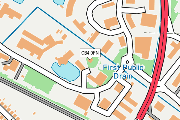
CB4 0FN is located in the Milton & Waterbeach electoral ward, within the local authority district of South Cambridgeshire and the English Parliamentary constituency of South East Cambridgeshire. The Sub Integrated Care Board (ICB) Location is NHS Cambridgeshire and Peterborough ICB - 06H and the police force is Cambridgeshire. This postcode has been in use since December 1998.


GetTheData
Source: OS OpenMap – Local (Ordnance Survey)
Source: OS VectorMap District (Ordnance Survey)
Licence: Open Government Licence (requires attribution)
| Easting | 546720 |
| Northing | 261488 |
| Latitude | 52.232059 |
| Longitude | 0.146998 |
GetTheData
Source: Open Postcode Geo
Licence: Open Government Licence
| Country | England |
| Postcode District | CB4 |
| ➜ CB4 open data dashboard ➜ See where CB4 is on a map ➜ Where is Cambridge? | |
GetTheData
Source: Land Registry Price Paid Data
Licence: Open Government Licence
Elevation or altitude of CB4 0FN as distance above sea level:
| Metres | Feet | |
|---|---|---|
| Elevation | 10m | 33ft |
Elevation is measured from the approximate centre of the postcode, to the nearest point on an OS contour line from OS Terrain 50, which has contour spacing of ten vertical metres.
➜ How high above sea level am I? Find the elevation of your current position using your device's GPS.
GetTheData
Source: Open Postcode Elevation
Licence: Open Government Licence
| Ward | Milton & Waterbeach |
| Constituency | South East Cambridgeshire |
GetTheData
Source: ONS Postcode Database
Licence: Open Government Licence
| January 2024 | Public order | On or near Park/Open Space | 396m |
| January 2024 | Anti-social behaviour | On or near Park/Open Space | 396m |
| November 2023 | Possession of weapons | On or near Park/Open Space | 396m |
| ➜ Get more crime data in our Crime section | |||
GetTheData
Source: data.police.uk
Licence: Open Government Licence
| Science Park (Science Park Entrance) | Cambridge | 160m |
| The Busway Science Park (Cambridgeshire Guided Busway) | Cambridge | 202m |
| The Busway Science Park (Cambridgeshire Guided Busway) | Cambridge | 221m |
| Science Park (Milton Road) | Cambridge | 224m |
| Science Park (Milton Road) | Cambridge | 248m |
| Cambridge Station | 4.3km |
| Waterbeach Station | 4.8km |
GetTheData
Source: NaPTAN
Licence: Open Government Licence
GetTheData
Source: ONS Postcode Database
Licence: Open Government Licence


➜ Get more ratings from the Food Standards Agency
GetTheData
Source: Food Standards Agency
Licence: FSA terms & conditions
| Last Collection | |||
|---|---|---|---|
| Location | Mon-Fri | Sat | Distance |
| Trinity Centre | 63m | ||
| Kings Hedges Road Post Office | 17:30 | 12:00 | 481m |
| Green Park | 17:30 | 12:15 | 620m |
GetTheData
Source: Dracos
Licence: Creative Commons Attribution-ShareAlike
| Facility | Distance |
|---|---|
| Revolution Health And Fitness Club Science Park, Milton Road, Cambridge Health and Fitness Gym, Studio, Squash Courts | 0m |
| Nunns Way Recreation Ground Nuns Way, Cambridge Grass Pitches, Cycling | 879m |
| St Georges Club Chesterfield Road, Cambridge Sports Hall | 927m |
GetTheData
Source: Active Places
Licence: Open Government Licence
| School | Phase of Education | Distance |
|---|---|---|
| Shirley Community Primary School Nuffield Road, Chesterton, Cambridge, CB4 1TF | Primary | 832m |
| Cambridge Regional College Science Park Campus, Kings Hedges Road, Cambridge, CB4 2QT | 16 plus | 913m |
| The Grove Primary School Campkin Road, Cambridge, CB4 2NB | Primary | 1.1km |
GetTheData
Source: Edubase
Licence: Open Government Licence
The below table lists the International Territorial Level (ITL) codes (formerly Nomenclature of Territorial Units for Statistics (NUTS) codes) and Local Administrative Units (LAU) codes for CB4 0FN:
| ITL 1 Code | Name |
|---|---|
| TLH | East |
| ITL 2 Code | Name |
| TLH1 | East Anglia |
| ITL 3 Code | Name |
| TLH12 | Cambridgeshire CC |
| LAU 1 Code | Name |
| E07000012 | South Cambridgeshire |
GetTheData
Source: ONS Postcode Directory
Licence: Open Government Licence
The below table lists the Census Output Area (OA), Lower Layer Super Output Area (LSOA), and Middle Layer Super Output Area (MSOA) for CB4 0FN:
| Code | Name | |
|---|---|---|
| OA | E00092161 | |
| LSOA | E01018274 | South Cambridgeshire 007C |
| MSOA | E02003781 | South Cambridgeshire 007 |
GetTheData
Source: ONS Postcode Directory
Licence: Open Government Licence
| CB4 2QR | Lovell Road | 326m |
| CB4 2QP | Lovell Road | 337m |
| CB4 2QW | Lovell Road | 357m |
| CB4 1TG | Trinity Hall Farm Industrial Estate | 360m |
| CB4 2QN | Lovell Road | 361m |
| CB4 1SZ | Milton Road | 366m |
| CB4 2PA | Kings Hedges Road | 405m |
| CB4 1SP | Milton Road | 446m |
| CB4 1ST | Milton Road | 447m |
| CB4 2QE | Kings Hedges Road | 450m |
GetTheData
Source: Open Postcode Geo; Land Registry Price Paid Data
Licence: Open Government Licence