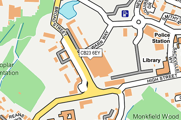
CB23 6EY is located in the Cambourne electoral ward, within the local authority district of South Cambridgeshire and the English Parliamentary constituency of South Cambridgeshire. The Sub Integrated Care Board (ICB) Location is NHS Cambridgeshire and Peterborough ICB - 06H and the police force is Cambridgeshire. This postcode has been in use since September 2006.


GetTheData
Source: OS OpenMap – Local (Ordnance Survey)
Source: OS VectorMap District (Ordnance Survey)
Licence: Open Government Licence (requires attribution)
| Easting | 531966 |
| Northing | 259636 |
| Latitude | 52.219135 |
| Longitude | -0.069652 |
GetTheData
Source: Open Postcode Geo
Licence: Open Government Licence
| Country | England |
| Postcode District | CB23 |
| ➜ CB23 open data dashboard ➜ See where CB23 is on a map ➜ Where is Cambourne? | |
GetTheData
Source: Land Registry Price Paid Data
Licence: Open Government Licence
Elevation or altitude of CB23 6EY as distance above sea level:
| Metres | Feet | |
|---|---|---|
| Elevation | 60m | 197ft |
Elevation is measured from the approximate centre of the postcode, to the nearest point on an OS contour line from OS Terrain 50, which has contour spacing of ten vertical metres.
➜ How high above sea level am I? Find the elevation of your current position using your device's GPS.
GetTheData
Source: Open Postcode Elevation
Licence: Open Government Licence
| Ward | Cambourne |
| Constituency | South Cambridgeshire |
GetTheData
Source: ONS Postcode Database
Licence: Open Government Licence
| June 2022 | Shoplifting | On or near Supermarket | 5m |
| June 2022 | Anti-social behaviour | On or near Broad Street | 70m |
| June 2022 | Burglary | On or near Broad Street | 70m |
| ➜ Get more crime data in our Crime section | |||
GetTheData
Source: data.police.uk
Licence: Open Government Licence
| De La Warr Way (Broad Street) | Cambourne | 38m |
| De La Warr Way (Broad Street) | Cambourne | 39m |
| Sackville Way (High Street) | Cambourne | 183m |
| Priory Walk (Monkfield Lane) | Great Cambourne | 199m |
| Monkfield Park Primary School (School Lane) | Cambourne | 249m |
GetTheData
Source: NaPTAN
Licence: Open Government Licence
GetTheData
Source: ONS Postcode Database
Licence: Open Government Licence


➜ Get more ratings from the Food Standards Agency
GetTheData
Source: Food Standards Agency
Licence: FSA terms & conditions
| Last Collection | |||
|---|---|---|---|
| Location | Mon-Fri | Sat | Distance |
| Monkfield Lane | 17:00 | 10:30 | 419m |
| School Lane | 16:45 | 10:30 | 457m |
| Monks Drive | 17:30 | 11:00 | 755m |
GetTheData
Source: Dracos
Licence: Creative Commons Attribution-ShareAlike
| Facility | Distance |
|---|---|
| The Cambridge Belfry Back Lane, Great Cambourne, Cambridge Swimming Pool, Health and Fitness Gym, Outdoor Tennis Courts | 294m |
| Monkfield Lane Tennis Court Monkfield Lane, Great Cambourne, Cambridge Outdoor Tennis Courts | 511m |
| Cambourne Fitness And Sports Centre Back Lane, Great Cambourne, Cambridge Sports Hall, Health and Fitness Gym, Studio | 576m |
GetTheData
Source: Active Places
Licence: Open Government Licence
| School | Phase of Education | Distance |
|---|---|---|
| Monkfield Park Primary School School Lane, Cambourne, Cambridge, CB23 5AX | Primary | 190m |
| Jeavons Wood Primary School Eastgate, Great Cambourne, CB23 6DZ | Primary | 551m |
| Cambourne Village College Sheepfold Lane, Cambourne, Cambridge, CB23 6FR | Secondary | 899m |
GetTheData
Source: Edubase
Licence: Open Government Licence
The below table lists the International Territorial Level (ITL) codes (formerly Nomenclature of Territorial Units for Statistics (NUTS) codes) and Local Administrative Units (LAU) codes for CB23 6EY:
| ITL 1 Code | Name |
|---|---|
| TLH | East |
| ITL 2 Code | Name |
| TLH1 | East Anglia |
| ITL 3 Code | Name |
| TLH12 | Cambridgeshire CC |
| LAU 1 Code | Name |
| E07000012 | South Cambridgeshire |
GetTheData
Source: ONS Postcode Directory
Licence: Open Government Licence
The below table lists the Census Output Area (OA), Lower Layer Super Output Area (LSOA), and Middle Layer Super Output Area (MSOA) for CB23 6EY:
| Code | Name | |
|---|---|---|
| OA | E00091954 | |
| LSOA | E01033114 | South Cambridgeshire 020B |
| MSOA | E02006873 | South Cambridgeshire 020 |
GetTheData
Source: ONS Postcode Directory
Licence: Open Government Licence
| CB23 6HH | Broad Street | 43m |
| CB23 6HJ | Broad Street | 89m |
| CB23 6EL | Broad Street | 95m |
| CB23 6DH | Broad Street | 97m |
| CB23 6JX | High Street | 105m |
| CB23 6HG | Broad Street | 112m |
| CB23 6GX | High Street | 123m |
| CB23 6HF | Broad Street | 144m |
| CB23 6HE | Broad Street | 162m |
| CB23 5BL | Priory Walk | 205m |
GetTheData
Source: Open Postcode Geo; Land Registry Price Paid Data
Licence: Open Government Licence