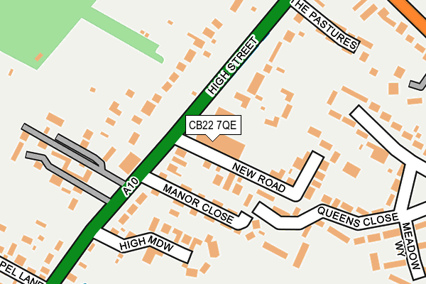
CB22 7QE is located in the Harston & Comberton electoral ward, within the local authority district of South Cambridgeshire and the English Parliamentary constituency of South Cambridgeshire. The Sub Integrated Care Board (ICB) Location is NHS Cambridgeshire and Peterborough ICB - 06H and the police force is Cambridgeshire. This postcode has been in use since September 2006.


GetTheData
Source: OS OpenMap – Local (Ordnance Survey)
Source: OS VectorMap District (Ordnance Survey)
Licence: Open Government Licence (requires attribution)
| Easting | 542928 |
| Northing | 251478 |
| Latitude | 52.143108 |
| Longitude | 0.087267 |
GetTheData
Source: Open Postcode Geo
Licence: Open Government Licence
| Country | England |
| Postcode District | CB22 |
| ➜ CB22 open data dashboard ➜ See where CB22 is on a map ➜ Where is Harston? | |
GetTheData
Source: Land Registry Price Paid Data
Licence: Open Government Licence
Elevation or altitude of CB22 7QE as distance above sea level:
| Metres | Feet | |
|---|---|---|
| Elevation | 10m | 33ft |
Elevation is measured from the approximate centre of the postcode, to the nearest point on an OS contour line from OS Terrain 50, which has contour spacing of ten vertical metres.
➜ How high above sea level am I? Find the elevation of your current position using your device's GPS.
GetTheData
Source: Open Postcode Elevation
Licence: Open Government Licence
| Ward | Harston & Comberton |
| Constituency | South Cambridgeshire |
GetTheData
Source: ONS Postcode Database
Licence: Open Government Licence
| January 2024 | Other theft | On or near Petrol Station | 118m |
| January 2024 | Other crime | On or near Petrol Station | 118m |
| November 2023 | Other theft | On or near Petrol Station | 118m |
| ➜ Get more crime data in our Crime section | |||
GetTheData
Source: data.police.uk
Licence: Open Government Licence
| High Meadow (High Street) | Harston | 137m |
| High Meadow (High Street) | Harston | 167m |
| Queens Close | Harston | 222m |
| London Road (High Street) | Harston | 231m |
| London Road (High Street) | Harston | 231m |
| Foxton Station | 3.4km |
| Shelford (Cambs) Station | 3.7km |
| Shepreth Station | 5km |
GetTheData
Source: NaPTAN
Licence: Open Government Licence
GetTheData
Source: ONS Postcode Database
Licence: Open Government Licence


➜ Get more ratings from the Food Standards Agency
GetTheData
Source: Food Standards Agency
Licence: FSA terms & conditions
| Last Collection | |||
|---|---|---|---|
| Location | Mon-Fri | Sat | Distance |
| Queens Close | 17:00 | 12:00 | 305m |
| London Road | 17:00 | 12:00 | 434m |
| Harston Post Office | 17:15 | 11:45 | 603m |
GetTheData
Source: Dracos
Licence: Creative Commons Attribution-ShareAlike
| Facility | Distance |
|---|---|
| Harston Recreation Ground Orchard Close, Harston, Cambridge Grass Pitches | 645m |
| Hauxton Sports Ground Cambridge Road, Hauxton Outdoor Tennis Courts, Grass Pitches | 1.1km |
| Hauxton Primary School Jopling Way, Hauxton, Cambridge Grass Pitches | 1.3km |
GetTheData
Source: Active Places
Licence: Open Government Licence
| School | Phase of Education | Distance |
|---|---|---|
| Harston and Newton Community Primary School High Street, Harston, Cambridge, CB22 7PX | Primary | 604m |
| Hauxton Primary School Jopling Way, Hauxton, Cambridge, CB22 5HY | Primary | 1.2km |
| Haslingfield Endowed Primary School High Street, Haslingfield, Cambridge, CB23 1JW | Primary | 2.4km |
GetTheData
Source: Edubase
Licence: Open Government Licence
The below table lists the International Territorial Level (ITL) codes (formerly Nomenclature of Territorial Units for Statistics (NUTS) codes) and Local Administrative Units (LAU) codes for CB22 7QE:
| ITL 1 Code | Name |
|---|---|
| TLH | East |
| ITL 2 Code | Name |
| TLH1 | East Anglia |
| ITL 3 Code | Name |
| TLH12 | Cambridgeshire CC |
| LAU 1 Code | Name |
| E07000012 | South Cambridgeshire |
GetTheData
Source: ONS Postcode Directory
Licence: Open Government Licence
The below table lists the Census Output Area (OA), Lower Layer Super Output Area (LSOA), and Middle Layer Super Output Area (MSOA) for CB22 7QE:
| Code | Name | |
|---|---|---|
| OA | E00092069 | |
| LSOA | E01018254 | South Cambridgeshire 014C |
| MSOA | E02003788 | South Cambridgeshire 014 |
GetTheData
Source: ONS Postcode Directory
Licence: Open Government Licence
| CB22 7AB | New Road | 100m |
| CB22 7QF | Manor Close | 106m |
| CB22 7TP | Moorfield | 113m |
| CB22 7QG | New Road | 126m |
| CB22 7QD | High Street | 140m |
| CB22 7TR | High Meadow | 141m |
| CB22 7QN | Queens Close | 192m |
| CB22 7QB | High Street | 214m |
| CB22 7QA | Sheepshead Lane | 218m |
| CB22 7QW | Queens Close | 265m |
GetTheData
Source: Open Postcode Geo; Land Registry Price Paid Data
Licence: Open Government Licence