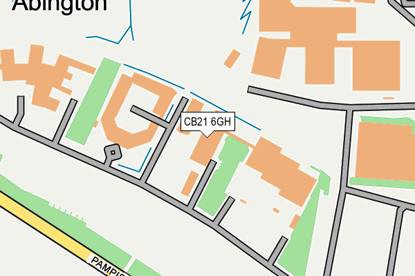
CB21 6GH is located in the Linton electoral ward, within the local authority district of South Cambridgeshire and the English Parliamentary constituency of South Cambridgeshire. The Sub Integrated Care Board (ICB) Location is NHS Cambridgeshire and Peterborough ICB - 06H and the police force is Cambridgeshire. This postcode has been in use since September 2006.


GetTheData
Source: OS OpenMap – Local (Ordnance Survey)
Source: OS VectorMap District (Ordnance Survey)
Licence: Open Government Licence (requires attribution)
| Easting | 552353 |
| Northing | 248702 |
| Latitude | 52.115653 |
| Longitude | 0.223649 |
GetTheData
Source: Open Postcode Geo
Licence: Open Government Licence
| Country | England |
| Postcode District | CB21 |
| ➜ CB21 open data dashboard ➜ See where CB21 is on a map ➜ Where is Great Abington? | |
GetTheData
Source: Land Registry Price Paid Data
Licence: Open Government Licence
Elevation or altitude of CB21 6GH as distance above sea level:
| Metres | Feet | |
|---|---|---|
| Elevation | 30m | 98ft |
Elevation is measured from the approximate centre of the postcode, to the nearest point on an OS contour line from OS Terrain 50, which has contour spacing of ten vertical metres.
➜ How high above sea level am I? Find the elevation of your current position using your device's GPS.
GetTheData
Source: Open Postcode Elevation
Licence: Open Government Licence
| Ward | Linton |
| Constituency | South Cambridgeshire |
GetTheData
Source: ONS Postcode Database
Licence: Open Government Licence
| December 2021 | Violence and sexual offences | On or near Conference/Exhibition Centre | 410m |
| June 2021 | Other theft | On or near Conference/Exhibition Centre | 410m |
| ➜ Get more crime data in our Crime section | |||
GetTheData
Source: data.police.uk
Licence: Open Government Licence
| Magna Close (High Street) | Great Abington | 837m |
| Magna Close (High Street) | Great Abington | 841m |
| Linton Road (High Street) | Great Abington | 928m |
| Linton Road (High Street) | Great Abington | 935m |
| High Street (Pampisford Road) | Great Abington | 990m |
| Whittlesford Parkway Station | 4.2km |
GetTheData
Source: NaPTAN
Licence: Open Government Licence
GetTheData
Source: ONS Postcode Database
Licence: Open Government Licence


➜ Get more ratings from the Food Standards Agency
GetTheData
Source: Food Standards Agency
Licence: FSA terms & conditions
| Last Collection | |||
|---|---|---|---|
| Location | Mon-Fri | Sat | Distance |
| Hildersham Village | 16:00 | 11:45 | 1,980m |
| High Street | 17:30 | 12:00 | 1,984m |
| Chequers Pub, High Street | 16:00 | 11:00 | 2,680m |
GetTheData
Source: Dracos
Licence: Creative Commons Attribution-ShareAlike
| Facility | Distance |
|---|---|
| Granta Park Cambridge, Great Abington Health and Fitness Gym, Grass Pitches, Swimming Pool | 127m |
| Abington Recreation Ground High Street, Great Abington, Cambridge Grass Pitches | 822m |
| Babraham Sports Field High Street, Babraham Grass Pitches | 2km |
GetTheData
Source: Active Places
Licence: Open Government Licence
| School | Phase of Education | Distance |
|---|---|---|
| Great Abington Primary School High Street, Abington, Cambridge, CB21 6AE | Primary | 976m |
| Babraham CofE (VC) Primary School High Street, Babraham, Cambridge, CB22 3AG | Primary | 1.9km |
| The Icknield Primary School Lynton Way, Cambridge, CB22 3EA | Primary | 3.2km |
GetTheData
Source: Edubase
Licence: Open Government Licence
The below table lists the International Territorial Level (ITL) codes (formerly Nomenclature of Territorial Units for Statistics (NUTS) codes) and Local Administrative Units (LAU) codes for CB21 6GH:
| ITL 1 Code | Name |
|---|---|
| TLH | East |
| ITL 2 Code | Name |
| TLH1 | East Anglia |
| ITL 3 Code | Name |
| TLH12 | Cambridgeshire CC |
| LAU 1 Code | Name |
| E07000012 | South Cambridgeshire |
GetTheData
Source: ONS Postcode Directory
Licence: Open Government Licence
The below table lists the Census Output Area (OA), Lower Layer Super Output Area (LSOA), and Middle Layer Super Output Area (MSOA) for CB21 6GH:
| Code | Name | |
|---|---|---|
| OA | E00092239 | |
| LSOA | E01018288 | South Cambridgeshire 017C |
| MSOA | E02003791 | South Cambridgeshire 017 |
GetTheData
Source: ONS Postcode Directory
Licence: Open Government Licence
| CB21 6AJ | Cutting Road | 592m |
| CB21 6AH | Pampisford Road | 690m |
| CB21 6AS | North Road | 730m |
| CB21 6AN | Bourne Bridge | 789m |
| CB21 6BE | West Field | 793m |
| CB21 6AE | High Street | 850m |
| CB21 6BJ | Bourn Bridge Road | 882m |
| CB21 6BA | Mortlock Gardens | 938m |
| CB21 6BQ | Church Lane | 965m |
| CB21 6AF | Magna Close | 967m |
GetTheData
Source: Open Postcode Geo; Land Registry Price Paid Data
Licence: Open Government Licence