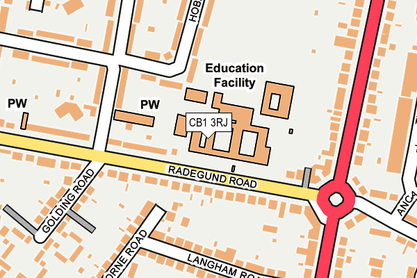
CB1 3RJ is located in the Coleridge electoral ward, within the local authority district of Cambridge and the English Parliamentary constituency of Cambridge. The Sub Integrated Care Board (ICB) Location is NHS Cambridgeshire and Peterborough ICB - 06H and the police force is Cambridgeshire. This postcode has been in use since January 1980.


GetTheData
Source: OS OpenMap – Local (Ordnance Survey)
Source: OS VectorMap District (Ordnance Survey)
Licence: Open Government Licence (requires attribution)
| Easting | 547178 |
| Northing | 257128 |
| Latitude | 52.192753 |
| Longitude | 0.151776 |
GetTheData
Source: Open Postcode Geo
Licence: Open Government Licence
| Country | England |
| Postcode District | CB1 |
| ➜ CB1 open data dashboard ➜ See where CB1 is on a map ➜ Where is Cambridge? | |
GetTheData
Source: Land Registry Price Paid Data
Licence: Open Government Licence
Elevation or altitude of CB1 3RJ as distance above sea level:
| Metres | Feet | |
|---|---|---|
| Elevation | 10m | 33ft |
Elevation is measured from the approximate centre of the postcode, to the nearest point on an OS contour line from OS Terrain 50, which has contour spacing of ten vertical metres.
➜ How high above sea level am I? Find the elevation of your current position using your device's GPS.
GetTheData
Source: Open Postcode Elevation
Licence: Open Government Licence
| Ward | Coleridge |
| Constituency | Cambridge |
GetTheData
Source: ONS Postcode Database
Licence: Open Government Licence
| June 2022 | Violence and sexual offences | On or near Radegund Road | 98m |
| June 2022 | Public order | On or near Radegund Road | 98m |
| June 2022 | Other crime | On or near Golding Road | 219m |
| ➜ Get more crime data in our Crime section | |||
GetTheData
Source: data.police.uk
Licence: Open Government Licence
| John Conder Court (Perne Road) | Cambridge | 193m |
| John Conder Court (Perne Road) | Cambridge | 204m |
| Langham Road (Perne Road) | Cambridge | 241m |
| Langham Road (Perne Road) | Cambridge | 257m |
| Perne Avenue (Perne Road) | Cambridge | 314m |
| Cambridge Station | 1km |
| Shelford (Cambs) Station | 5km |
GetTheData
Source: NaPTAN
Licence: Open Government Licence
GetTheData
Source: ONS Postcode Database
Licence: Open Government Licence


➜ Get more ratings from the Food Standards Agency
GetTheData
Source: Food Standards Agency
Licence: FSA terms & conditions
| Last Collection | |||
|---|---|---|---|
| Location | Mon-Fri | Sat | Distance |
| Brookfields Post Office | 18:30 | 12:30 | 190m |
| Coleridge Road | 18:30 | 13:00 | 353m |
| Litchfield Road | 18:45 | 13:15 | 380m |
GetTheData
Source: Dracos
Licence: Creative Commons Attribution-ShareAlike
| Facility | Distance |
|---|---|
| Coleridge Community College Radegund Road, Cambridge Sports Hall, Grass Pitches, Artificial Grass Pitch | 0m |
| Coleridge Recreation Ground Davy Road, Cambridge Grass Pitches, Outdoor Tennis Courts | 527m |
| St Bedes Inter Church School Birdwood Road, Cambridge Sports Hall, Grass Pitches, Studio, Health and Fitness Gym, Outdoor Tennis Courts | 771m |
GetTheData
Source: Active Places
Licence: Open Government Licence
| School | Phase of Education | Distance |
|---|---|---|
| Ridgefield Primary School Radegund Road, Cambridge, CB1 3RL | Primary | 0m |
| Coleridge Community College Radegund Road, Cambridge, CB1 3RJ | Secondary | 0m |
| St Bede's Inter-Church School Birdwood Road, Cambridge, CB1 3TD | Secondary | 771m |
GetTheData
Source: Edubase
Licence: Open Government Licence
The below table lists the International Territorial Level (ITL) codes (formerly Nomenclature of Territorial Units for Statistics (NUTS) codes) and Local Administrative Units (LAU) codes for CB1 3RJ:
| ITL 1 Code | Name |
|---|---|
| TLH | East |
| ITL 2 Code | Name |
| TLH1 | East Anglia |
| ITL 3 Code | Name |
| TLH12 | Cambridgeshire CC |
| LAU 1 Code | Name |
| E07000008 | Cambridge |
GetTheData
Source: ONS Postcode Directory
Licence: Open Government Licence
The below table lists the Census Output Area (OA), Lower Layer Super Output Area (LSOA), and Middle Layer Super Output Area (MSOA) for CB1 3RJ:
| Code | Name | |
|---|---|---|
| OA | E00090634 | |
| LSOA | E01017967 | Cambridge 010C |
| MSOA | E02003728 | Cambridge 010 |
GetTheData
Source: ONS Postcode Directory
Licence: Open Government Licence
| CB1 3RS | Radegund Road | 75m |
| CB1 3RH | Radegund Road | 133m |
| CB1 3SE | Langham Road | 163m |
| CB1 3PT | Hobart Road | 182m |
| CB1 3SD | Langham Road | 199m |
| CB1 3RZ | Gisborne Road | 220m |
| CB1 3QD | Suez Road | 221m |
| CB1 3RL | Radegund Road | 223m |
| CB1 3SB | Perne Road | 224m |
| CB1 3NT | Perne Road | 225m |
GetTheData
Source: Open Postcode Geo; Land Registry Price Paid Data
Licence: Open Government Licence