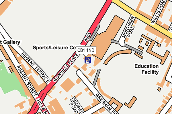
CB1 1ND is located in the Market electoral ward, within the local authority district of Cambridge and the English Parliamentary constituency of Cambridge. The Sub Integrated Care Board (ICB) Location is NHS Cambridgeshire and Peterborough ICB - 06H and the police force is Cambridgeshire. This postcode has been in use since January 1980.


GetTheData
Source: OS OpenMap – Local (Ordnance Survey)
Source: OS VectorMap District (Ordnance Survey)
Licence: Open Government Licence (requires attribution)
| Easting | 545650 |
| Northing | 257962 |
| Latitude | 52.200651 |
| Longitude | 0.129797 |
GetTheData
Source: Open Postcode Geo
Licence: Open Government Licence
| Country | England |
| Postcode District | CB1 |
| ➜ CB1 open data dashboard ➜ See where CB1 is on a map ➜ Where is Cambridge? | |
GetTheData
Source: Land Registry Price Paid Data
Licence: Open Government Licence
Elevation or altitude of CB1 1ND as distance above sea level:
| Metres | Feet | |
|---|---|---|
| Elevation | 10m | 33ft |
Elevation is measured from the approximate centre of the postcode, to the nearest point on an OS contour line from OS Terrain 50, which has contour spacing of ten vertical metres.
➜ How high above sea level am I? Find the elevation of your current position using your device's GPS.
GetTheData
Source: Open Postcode Elevation
Licence: Open Government Licence
| Ward | Market |
| Constituency | Cambridge |
GetTheData
Source: ONS Postcode Database
Licence: Open Government Licence
| June 2022 | Drugs | On or near Gonville Place | 40m |
| June 2022 | Drugs | On or near Gonville Place | 40m |
| June 2022 | Other crime | On or near Gonville Place | 40m |
| ➜ Get more crime data in our Crime section | |||
GetTheData
Source: data.police.uk
Licence: Open Government Licence
| Gonville Place | Cambridge | 107m |
| Gonville Place | Cambridge | 120m |
| Mortimer Road (Mill Road) | Cambridge | 234m |
| The Busway Parkside (Parkside) | Cambridge | 245m |
| Downing College (Regent Street) | Cambridge | 253m |
| Cambridge Station | 0.9km |
GetTheData
Source: NaPTAN
Licence: Open Government Licence
GetTheData
Source: ONS Postcode Database
Licence: Open Government Licence


➜ Get more ratings from the Food Standards Agency
GetTheData
Source: Food Standards Agency
Licence: FSA terms & conditions
| Last Collection | |||
|---|---|---|---|
| Location | Mon-Fri | Sat | Distance |
| Petersfield Post Office | 19:00 | 12:00 | 312m |
| Regent Street Post Office | 18:45 | 12:00 | 322m |
| Parkside | 18:30 | 12:00 | 323m |
GetTheData
Source: Dracos
Licence: Creative Commons Attribution-ShareAlike
| Facility | Distance |
|---|---|
| Ymca (Cambridge) Gonville Place, Cambridge Health and Fitness Gym, Studio | 9m |
| Kelsey Kerridge Sports Centre Queen Anne Terrace, Cambridge Sports Hall, Health and Fitness Gym, Studio, Squash Courts | 72m |
| Parkside Pools & Gym Gonville Place, Cambridge Swimming Pool, Studio, Health and Fitness Gym | 141m |
GetTheData
Source: Active Places
Licence: Open Government Licence
| School | Phase of Education | Distance |
|---|---|---|
| Cardiff Sixth Form College, Cambridge 89 Regent Street, Cambridge, CB1 2AW | Not applicable | 212m |
| Sancton Wood School 2 St Pauls Road, CB1 2EZ | Not applicable | 281m |
| St Alban's Catholic Primary School Lensfield Road, Cambridge, CB2 1EN | Primary | 333m |
GetTheData
Source: Edubase
Licence: Open Government Licence
The below table lists the International Territorial Level (ITL) codes (formerly Nomenclature of Territorial Units for Statistics (NUTS) codes) and Local Administrative Units (LAU) codes for CB1 1ND:
| ITL 1 Code | Name |
|---|---|
| TLH | East |
| ITL 2 Code | Name |
| TLH1 | East Anglia |
| ITL 3 Code | Name |
| TLH12 | Cambridgeshire CC |
| LAU 1 Code | Name |
| E07000008 | Cambridge |
GetTheData
Source: ONS Postcode Directory
Licence: Open Government Licence
The below table lists the Census Output Area (OA), Lower Layer Super Output Area (LSOA), and Middle Layer Super Output Area (MSOA) for CB1 1ND:
| Code | Name | |
|---|---|---|
| OA | E00090802 | |
| LSOA | E01018005 | Cambridge 012D |
| MSOA | E02003730 | Cambridge 012 |
GetTheData
Source: ONS Postcode Directory
Licence: Open Government Licence
| CB1 2EB | Gresham Place | 44m |
| CB1 2EH | Fenners Lawn | 127m |
| CB1 2EP | Gresham Road | 132m |
| CB1 2EY | Drosier Road | 140m |
| CB1 2ET | Harvey Road | 180m |
| CB1 2EL | Eden Street | 190m |
| CB2 1DP | Regent Street | 240m |
| CB2 1AA | Regent Terrace | 251m |
| CB2 1AB | Regent Street | 266m |
| CB1 1HQ | Parkside Place | 269m |
GetTheData
Source: Open Postcode Geo; Land Registry Price Paid Data
Licence: Open Government Licence