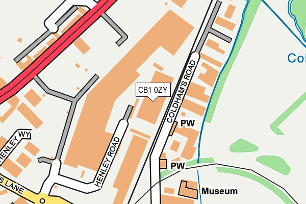
CB1 0ZY is located in the Abbey electoral ward, within the local authority district of Cambridge and the English Parliamentary constituency of Cambridge. The Sub Integrated Care Board (ICB) Location is NHS Cambridgeshire and Peterborough ICB - 06H and the police force is Cambridgeshire. This postcode has been in use since March 2016.


GetTheData
Source: OS OpenMap – Local (Ordnance Survey)
Source: OS VectorMap District (Ordnance Survey)
Licence: Open Government Licence (requires attribution)
| Easting | 546881 |
| Northing | 258966 |
| Latitude | 52.209345 |
| Longitude | 0.148231 |
GetTheData
Source: Open Postcode Geo
Licence: Open Government Licence
| Country | England |
| Postcode District | CB1 |
| ➜ CB1 open data dashboard ➜ See where CB1 is on a map | |
GetTheData
Source: Land Registry Price Paid Data
Licence: Open Government Licence
Elevation or altitude of CB1 0ZY as distance above sea level:
| Metres | Feet | |
|---|---|---|
| Elevation | 10m | 33ft |
Elevation is measured from the approximate centre of the postcode, to the nearest point on an OS contour line from OS Terrain 50, which has contour spacing of ten vertical metres.
➜ How high above sea level am I? Find the elevation of your current position using your device's GPS.
GetTheData
Source: Open Postcode Elevation
Licence: Open Government Licence
| Ward | Abbey |
| Constituency | Cambridge |
GetTheData
Source: ONS Postcode Database
Licence: Open Government Licence
| January 2024 | Shoplifting | On or near Parking Area | 395m |
| January 2024 | Anti-social behaviour | On or near Parking Area | 395m |
| January 2024 | Anti-social behaviour | On or near Parking Area | 395m |
| ➜ Get more crime data in our Crime section | |||
GetTheData
Source: data.police.uk
Licence: Open Government Licence
| Homebase (Cambridge Retail Park) | Cambridge | 174m |
| Retail Park (Newmarket Rd) | Cambridge | 207m |
| Homebase (Cambridge Retail Park) | Cambridge | 211m |
| River Lane (Newmarket Road) | Cambridge | 284m |
| Stanley Road (Newmarket Road) | Cambridge | 341m |
| Cambridge Station | 1.9km |
GetTheData
Source: NaPTAN
Licence: Open Government Licence
GetTheData
Source: ONS Postcode Database
Licence: Open Government Licence


➜ Get more ratings from the Food Standards Agency
GetTheData
Source: Food Standards Agency
Licence: FSA terms & conditions
| Last Collection | |||
|---|---|---|---|
| Location | Mon-Fri | Sat | Distance |
| Cambridge Delivery Office | 17:45 | 12:45 | 58m |
| Silverwood Close | 18:00 | 12:30 | 360m |
| Tesco Stores | 18:15 | 12:00 | 368m |
GetTheData
Source: Dracos
Licence: Creative Commons Attribution-ShareAlike
| Facility | Distance |
|---|---|
| The Gym Group (Cambridge) Henley Road, Henley Road, Cambridge Health and Fitness Gym | 86m |
| Nuffield Health (Cambridge) Cromwell Road, Cambridge Swimming Pool, Health and Fitness Gym, Studio | 331m |
| Abbey Leisure Complex Pool Way, Cambridge Swimming Pool, Health and Fitness Gym, Artificial Grass Pitch, Grass Pitches, Studio | 433m |
GetTheData
Source: Active Places
Licence: Open Government Licence
| School | Phase of Education | Distance |
|---|---|---|
| Brunswick Nursery School Young Street, Cambridge, CB1 2LZ | Nursery | 725m |
| The Fields Nursery School Galfrid Road, Cambridge, CB5 8ND | Nursery | 926m |
| The Galfrid School Galfrid Road, Cambridge, CB5 8ND | Primary | 954m |
GetTheData
Source: Edubase
Licence: Open Government Licence
The below table lists the International Territorial Level (ITL) codes (formerly Nomenclature of Territorial Units for Statistics (NUTS) codes) and Local Administrative Units (LAU) codes for CB1 0ZY:
| ITL 1 Code | Name |
|---|---|
| TLH | East |
| ITL 2 Code | Name |
| TLH1 | East Anglia |
| ITL 3 Code | Name |
| TLH12 | Cambridgeshire CC |
| LAU 1 Code | Name |
| E07000008 | Cambridge |
GetTheData
Source: ONS Postcode Directory
Licence: Open Government Licence
The below table lists the Census Output Area (OA), Lower Layer Super Output Area (LSOA), and Middle Layer Super Output Area (MSOA) for CB1 0ZY:
| Code | Name | |
|---|---|---|
| OA | E00090513 | |
| LSOA | E01017943 | Cambridge 006A |
| MSOA | E02003724 | Cambridge 006 |
GetTheData
Source: ONS Postcode Directory
Licence: Open Government Licence
| CB5 8JH | Newmarket Road | 240m |
| CB5 8JG | Newmarket Road | 248m |
| CB5 8JE | Newmarket Road | 249m |
| CB1 3EP | Coldhams Lane | 325m |
| CB5 8LD | Cheddars Lane | 361m |
| CB1 3HA | Silverwood Close | 374m |
| CB1 3FB | Cromwell Road | 375m |
| CB5 8JJ | Newmarket Road | 426m |
| CB5 8HP | River Lane | 432m |
| CB1 3FA | Cromwell Road | 434m |
GetTheData
Source: Open Postcode Geo; Land Registry Price Paid Data
Licence: Open Government Licence