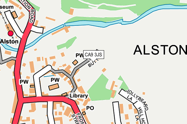
CA9 3JS is located in the Alston and Fellside electoral ward, within the unitary authority of Westmorland and Furness and the English Parliamentary constituency of Penrith and The Border. The Sub Integrated Care Board (ICB) Location is NHS North East and North Cumbria ICB - 01H and the police force is Cumbria. This postcode has been in use since January 1980.


GetTheData
Source: OS OpenMap – Local (Ordnance Survey)
Source: OS VectorMap District (Ordnance Survey)
Licence: Open Government Licence (requires attribution)
| Easting | 371965 |
| Northing | 546617 |
| Latitude | 54.813620 |
| Longitude | -2.437756 |
GetTheData
Source: Open Postcode Geo
Licence: Open Government Licence
| Country | England |
| Postcode District | CA9 |
| ➜ CA9 open data dashboard ➜ See where CA9 is on a map ➜ Where is Alston? | |
GetTheData
Source: Land Registry Price Paid Data
Licence: Open Government Licence
Elevation or altitude of CA9 3JS as distance above sea level:
| Metres | Feet | |
|---|---|---|
| Elevation | 300m | 984ft |
Elevation is measured from the approximate centre of the postcode, to the nearest point on an OS contour line from OS Terrain 50, which has contour spacing of ten vertical metres.
➜ How high above sea level am I? Find the elevation of your current position using your device's GPS.
GetTheData
Source: Open Postcode Elevation
Licence: Open Government Licence
| Ward | Alston And Fellside |
| Constituency | Penrith And The Border |
GetTheData
Source: ONS Postcode Database
Licence: Open Government Licence
| January 2024 | Violence and sexual offences | On or near Parking Area | 161m |
| December 2023 | Violence and sexual offences | On or near Parking Area | 161m |
| December 2023 | Violence and sexual offences | On or near Parking Area | 161m |
| ➜ Get more crime data in our Crime section | |||
GetTheData
Source: data.police.uk
Licence: Open Government Licence
| Station Yard (Station Yard Workshops) | Alston | 231m |
| Station Yard Workshops (Station Road) | Alston | 244m |
| Fire Station (Victoria Square) | Alston | 268m |
| Town Head (Victoria Square) | Alston | 273m |
| Hendersons Garage (Station Road) | Alston | 369m |
| Alston (South Tynedale Railway) (Station Road) | Alston | 280m |
GetTheData
Source: NaPTAN
Licence: Open Government Licence
| Percentage of properties with Next Generation Access | 100.0% |
| Percentage of properties with Superfast Broadband | 100.0% |
| Percentage of properties with Ultrafast Broadband | 0.0% |
| Percentage of properties with Full Fibre Broadband | 0.0% |
Superfast Broadband is between 30Mbps and 300Mbps
Ultrafast Broadband is > 300Mbps
| Percentage of properties unable to receive 2Mbps | 0.0% |
| Percentage of properties unable to receive 5Mbps | 0.0% |
| Percentage of properties unable to receive 10Mbps | 0.0% |
| Percentage of properties unable to receive 30Mbps | 0.0% |
GetTheData
Source: Ofcom
Licence: Ofcom Terms of Use (requires attribution)
GetTheData
Source: ONS Postcode Database
Licence: Open Government Licence


➜ Get more ratings from the Food Standards Agency
GetTheData
Source: Food Standards Agency
Licence: FSA terms & conditions
| Last Collection | |||
|---|---|---|---|
| Location | Mon-Fri | Sat | Distance |
| Alston | 16:40 | 12:00 | 173m |
| Town Foot | 16:45 | 11:30 | 217m |
| Town Head | 16:30 | 11:00 | 326m |
GetTheData
Source: Dracos
Licence: Creative Commons Attribution-ShareAlike
| Facility | Distance |
|---|---|
| Alston Moor Fitness Club Station Road, Alston Health and Fitness Gym | 303m |
| Samuel Kings School Church Road, Alston Sports Hall, Artificial Grass Pitch | 318m |
| Tyne Willows Playing Fields Station Road, Alston Grass Pitches | 360m |
GetTheData
Source: Active Places
Licence: Open Government Licence
| School | Phase of Education | Distance |
|---|---|---|
| Alston Primary School Church Road, Alston, CA9 3QU | Primary | 318m |
| Samuel King's School Church Road, Alston, CA9 3QU | Secondary | 318m |
GetTheData
Source: Edubase
Licence: Open Government Licence
The below table lists the International Territorial Level (ITL) codes (formerly Nomenclature of Territorial Units for Statistics (NUTS) codes) and Local Administrative Units (LAU) codes for CA9 3JS:
| ITL 1 Code | Name |
|---|---|
| TLD | North West (England) |
| ITL 2 Code | Name |
| TLD1 | Cumbria |
| ITL 3 Code | Name |
| TLD12 | East Cumbria |
| LAU 1 Code | Name |
| E07000030 | Eden |
GetTheData
Source: ONS Postcode Directory
Licence: Open Government Licence
The below table lists the Census Output Area (OA), Lower Layer Super Output Area (LSOA), and Middle Layer Super Output Area (MSOA) for CA9 3JS:
| Code | Name | |
|---|---|---|
| OA | E00097573 | |
| LSOA | E01019305 | Eden 001A |
| MSOA | E02004008 | Eden 001 |
GetTheData
Source: ONS Postcode Directory
Licence: Open Government Licence
| CA9 3JJ | Gilmore Close | 77m |
| CA9 3JU | The Butts | 86m |
| CA9 3JH | Sunset View | 87m |
| CA9 3JQ | The Butts | 95m |
| CA9 3HS | Market Place | 134m |
| CA9 3JG | School Terrace | 151m |
| CA9 3HP | Front Street | 166m |
| CA9 3QH | Front Street | 169m |
| CA9 3QN | Market Place | 171m |
| CA9 3QW | Front Street | 177m |
GetTheData
Source: Open Postcode Geo; Land Registry Price Paid Data
Licence: Open Government Licence