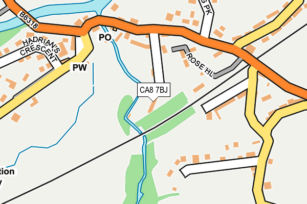
CA8 7BJ lies on Riversdale in Gilsland, Brampton. CA8 7BJ is located in the Haydon and Hadrian electoral ward, within the unitary authority of Northumberland and the English Parliamentary constituency of Hexham. The Sub Integrated Care Board (ICB) Location is NHS North East and North Cumbria ICB - 00L and the police force is Northumbria. This postcode has been in use since June 2000.


GetTheData
Source: OS OpenMap – Local (Ordnance Survey)
Source: OS VectorMap District (Ordnance Survey)
Licence: Open Government Licence (requires attribution)
| Easting | 363459 |
| Northing | 566307 |
| Latitude | 54.990001 |
| Longitude | -2.572611 |
GetTheData
Source: Open Postcode Geo
Licence: Open Government Licence
| Street | Riversdale |
| Locality | Gilsland |
| Town/City | Brampton |
| Country | England |
| Postcode District | CA8 |
➜ See where CA8 is on a map ➜ Where is Gilsland? | |
GetTheData
Source: Land Registry Price Paid Data
Licence: Open Government Licence
Elevation or altitude of CA8 7BJ as distance above sea level:
| Metres | Feet | |
|---|---|---|
| Elevation | 130m | 427ft |
Elevation is measured from the approximate centre of the postcode, to the nearest point on an OS contour line from OS Terrain 50, which has contour spacing of ten vertical metres.
➜ How high above sea level am I? Find the elevation of your current position using your device's GPS.
GetTheData
Source: Open Postcode Elevation
Licence: Open Government Licence
| Ward | Haydon And Hadrian |
| Constituency | Hexham |
GetTheData
Source: ONS Postcode Database
Licence: Open Government Licence
| Post Office (B6318) | Gilsland | 137m |
| Post Office (B6318) | Gilsland | 147m |
| Bridge Inn (B6318) | Gilsland | 186m |
| Dinmont House (B6318) | Gilsland | 203m |
| Bridge Inn (B6318) | Gilsland | 204m |
GetTheData
Source: NaPTAN
Licence: Open Government Licence
| Percentage of properties with Next Generation Access | 100.0% |
| Percentage of properties with Superfast Broadband | 100.0% |
| Percentage of properties with Ultrafast Broadband | 0.0% |
| Percentage of properties with Full Fibre Broadband | 0.0% |
Superfast Broadband is between 30Mbps and 300Mbps
Ultrafast Broadband is > 300Mbps
| Percentage of properties unable to receive 2Mbps | 0.0% |
| Percentage of properties unable to receive 5Mbps | 0.0% |
| Percentage of properties unable to receive 10Mbps | 0.0% |
| Percentage of properties unable to receive 30Mbps | 0.0% |
GetTheData
Source: Ofcom
Licence: Ofcom Terms of Use (requires attribution)
GetTheData
Source: ONS Postcode Database
Licence: Open Government Licence


➜ Get more ratings from the Food Standards Agency
GetTheData
Source: Food Standards Agency
Licence: FSA terms & conditions
| Last Collection | |||
|---|---|---|---|
| Location | Mon-Fri | Sat | Distance |
| Gilsland | 16:45 | 11:00 | 163m |
| Crooks | 16:45 | 11:00 | 237m |
| Orchard House | 16:30 | 11:00 | 494m |
GetTheData
Source: Dracos
Licence: Creative Commons Attribution-ShareAlike
| Risk of CA8 7BJ flooding from rivers and sea | Medium |
| ➜ CA8 7BJ flood map | |
GetTheData
Source: Open Flood Risk by Postcode
Licence: Open Government Licence
The below table lists the International Territorial Level (ITL) codes (formerly Nomenclature of Territorial Units for Statistics (NUTS) codes) and Local Administrative Units (LAU) codes for CA8 7BJ:
| ITL 1 Code | Name |
|---|---|
| TLC | North East (England) |
| ITL 2 Code | Name |
| TLC2 | Northumberland, and Tyne and Wear |
| ITL 3 Code | Name |
| TLC21 | Northumberland |
| LAU 1 Code | Name |
| E06000057 | Northumberland |
GetTheData
Source: ONS Postcode Directory
Licence: Open Government Licence
The below table lists the Census Output Area (OA), Lower Layer Super Output Area (LSOA), and Middle Layer Super Output Area (MSOA) for CA8 7BJ:
| Code | Name | |
|---|---|---|
| OA | E00139880 | |
| LSOA | E01027484 | Northumberland 037A |
| MSOA | E02005728 | Northumberland 037 |
GetTheData
Source: ONS Postcode Directory
Licence: Open Government Licence
| CA8 7BU | Carlton Trice | 107m |
| CA8 7BH | Stanley Crescent | 116m |
| CA8 7DW | 127m | |
| CA8 7DS | 127m | |
| CA8 7BL | Railway Terrace | 134m |
| CA8 7DX | 139m | |
| CA8 7BQ | Thirlwall Villas | 140m |
| CA8 7BD | Thirlwall Terrace | 145m |
| CA8 7BE | 150m | |
| CA8 7DN | Railway Terrace | 156m |
GetTheData
Source: Open Postcode Geo; Land Registry Price Paid Data
Licence: Open Government Licence