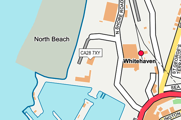
CA28 7XY lies on North Shore in Whitehaven. CA28 7XY is located in the Bransty electoral ward, within the unitary authority of Cumberland and the English Parliamentary constituency of Copeland. The Sub Integrated Care Board (ICB) Location is NHS North East and North Cumbria ICB - 01H and the police force is Cumbria. This postcode has been in use since March 1983.


GetTheData
Source: OS OpenMap – Local (Ordnance Survey)
Source: OS VectorMap District (Ordnance Survey)
Licence: Open Government Licence (requires attribution)
| Easting | 297250 |
| Northing | 518600 |
| Latitude | 54.552186 |
| Longitude | -3.590148 |
GetTheData
Source: Open Postcode Geo
Licence: Open Government Licence
| Street | North Shore |
| Town/City | Whitehaven |
| Country | England |
| Postcode District | CA28 |
| ➜ CA28 open data dashboard ➜ See where CA28 is on a map ➜ Where is Whitehaven? | |
GetTheData
Source: Land Registry Price Paid Data
Licence: Open Government Licence
Elevation or altitude of CA28 7XY as distance above sea level:
| Metres | Feet | |
|---|---|---|
| Elevation | 10m | 33ft |
Elevation is measured from the approximate centre of the postcode, to the nearest point on an OS contour line from OS Terrain 50, which has contour spacing of ten vertical metres.
➜ How high above sea level am I? Find the elevation of your current position using your device's GPS.
GetTheData
Source: Open Postcode Elevation
Licence: Open Government Licence
| Ward | Bransty |
| Constituency | Copeland |
GetTheData
Source: ONS Postcode Database
Licence: Open Government Licence
| January 2024 | Violence and sexual offences | On or near Parking Area | 314m |
| January 2024 | Violence and sexual offences | On or near Parking Area | 314m |
| December 2023 | Burglary | On or near Lonsdale Street | 401m |
| ➜ Get more crime data in our Crime section | |||
GetTheData
Source: data.police.uk
Licence: Open Government Licence
| Tesco (Unnamed Road) | Whitehaven | 173m |
| Tangier Street (Bransty Row) | Whitehaven | 209m |
| Rail Station (Station Road) | Whitehaven | 213m |
| Tangier Street (Bransty Row) | Whitehaven | 227m |
| Countess Road (Bransty Road) | Bransty | 446m |
| Whitehaven Station | 0.2km |
| Corkickle Station | 1.3km |
| Parton Station | 2.1km |
GetTheData
Source: NaPTAN
Licence: Open Government Licence
GetTheData
Source: ONS Postcode Database
Licence: Open Government Licence


➜ Get more ratings from the Food Standards Agency
GetTheData
Source: Food Standards Agency
Licence: FSA terms & conditions
| Last Collection | |||
|---|---|---|---|
| Location | Mon-Fri | Sat | Distance |
| Bransty Row | 17:30 | 12:00 | 225m |
| Tangier Street | 18:30 | 12:00 | 287m |
| Bransty | 17:30 | 12:00 | 434m |
GetTheData
Source: Dracos
Licence: Creative Commons Attribution-ShareAlike
| Facility | Distance |
|---|---|
| Bransty Playing Field Bransty Road, Whitehaven Grass Pitches | 534m |
| The Leisure Club (Closed) Howgill Street, Whitehaven Studio, Health and Fitness Gym, Swimming Pool | 723m |
| Ymca (Whitehaven) (Closed) Irish Street, Whitehaven Sports Hall | 749m |
GetTheData
Source: Active Places
Licence: Open Government Licence
| School | Phase of Education | Distance |
|---|---|---|
| St James' CofE Infant and Nursery School High Street, Whitehaven, CA28 7PZ | Primary | 411m |
| St James' CofE Junior School Wellington Row, Whitehaven, CA28 7HG | Primary | 477m |
| Bransty Primary School Mona Road, Bransty, Whitehaven, CA28 6EG | Primary | 950m |
GetTheData
Source: Edubase
Licence: Open Government Licence
The below table lists the International Territorial Level (ITL) codes (formerly Nomenclature of Territorial Units for Statistics (NUTS) codes) and Local Administrative Units (LAU) codes for CA28 7XY:
| ITL 1 Code | Name |
|---|---|
| TLD | North West (England) |
| ITL 2 Code | Name |
| TLD1 | Cumbria |
| ITL 3 Code | Name |
| TLD11 | West Cumbria |
| LAU 1 Code | Name |
| E07000029 | Copeland |
GetTheData
Source: ONS Postcode Directory
Licence: Open Government Licence
The below table lists the Census Output Area (OA), Lower Layer Super Output Area (LSOA), and Middle Layer Super Output Area (MSOA) for CA28 7XY:
| Code | Name | |
|---|---|---|
| OA | E00097348 | |
| LSOA | E01019260 | Copeland 002A |
| MSOA | E02004001 | Copeland 002 |
GetTheData
Source: ONS Postcode Directory
Licence: Open Government Licence
| CA28 7UJ | Millennium Promenade | 250m |
| CA28 7HR | Duke Street | 254m |
| CA28 7UZ | Tangier Street | 268m |
| CA28 6AZ | Bransty Road | 272m |
| CA28 7EW | Duke Street | 279m |
| CA28 7UX | Tangier Street | 279m |
| CA28 7HD | Herbert Hill | 284m |
| CA28 7HA | Wellington Row | 297m |
| CA28 7EZ | George Street | 302m |
| CA28 7EN | Duke Street | 320m |
GetTheData
Source: Open Postcode Geo; Land Registry Price Paid Data
Licence: Open Government Licence