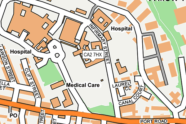
CA2 7HX is located in the Castle electoral ward, within the unitary authority of Cumberland and the English Parliamentary constituency of Carlisle. The Sub Integrated Care Board (ICB) Location is NHS North East and North Cumbria ICB - 01H and the police force is Cumbria. This postcode has been in use since December 1994.


GetTheData
Source: OS OpenMap – Local (Ordnance Survey)
Source: OS VectorMap District (Ordnance Survey)
Licence: Open Government Licence (requires attribution)
| Easting | 338671 |
| Northing | 556172 |
| Latitude | 54.896504 |
| Longitude | -2.957796 |
GetTheData
Source: Open Postcode Geo
Licence: Open Government Licence
| Country | England |
| Postcode District | CA2 |
| ➜ CA2 open data dashboard ➜ See where CA2 is on a map ➜ Where is Carlisle? | |
GetTheData
Source: Land Registry Price Paid Data
Licence: Open Government Licence
Elevation or altitude of CA2 7HX as distance above sea level:
| Metres | Feet | |
|---|---|---|
| Elevation | 20m | 66ft |
Elevation is measured from the approximate centre of the postcode, to the nearest point on an OS contour line from OS Terrain 50, which has contour spacing of ten vertical metres.
➜ How high above sea level am I? Find the elevation of your current position using your device's GPS.
GetTheData
Source: Open Postcode Elevation
Licence: Open Government Licence
| Ward | Castle |
| Constituency | Carlisle |
GetTheData
Source: ONS Postcode Database
Licence: Open Government Licence
| June 2022 | Anti-social behaviour | On or near Parking Area | 58m |
| June 2022 | Criminal damage and arson | On or near Parking Area | 58m |
| June 2022 | Drugs | On or near Parking Area | 58m |
| ➜ Get more crime data in our Crime section | |||
GetTheData
Source: data.police.uk
Licence: Open Government Licence
| Infirmary Main Entrance (Unnamed Road) | Engine Lonning | 66m |
| Pedestrian Arms (Newtown Road) | Newtown | 254m |
| Infirmary Street (Newtown Road) | Newtown | 301m |
| Raffles Avenue (Newtown Road) | Newtown | 329m |
| Raffles Avenue (Newtown Road) | Newtown | 338m |
| Carlisle Station | 1.7km |
GetTheData
Source: NaPTAN
Licence: Open Government Licence
GetTheData
Source: ONS Postcode Database
Licence: Open Government Licence


➜ Get more ratings from the Food Standards Agency
GetTheData
Source: Food Standards Agency
Licence: FSA terms & conditions
| Last Collection | |||
|---|---|---|---|
| Location | Mon-Fri | Sat | Distance |
| Cumberland Infirmary | 16:45 | 12:00 | 13m |
| Newtown | 18:45 | 13:15 | 249m |
| Port Road Business Park | 17:15 | 12:00 | 323m |
GetTheData
Source: Dracos
Licence: Creative Commons Attribution-ShareAlike
| Facility | Distance |
|---|---|
| Newtown Primary School Newtown Road, Carlisle Grass Pitches, Sports Hall | 454m |
| Creighton Rugby Football Club (Closed) Caxton Road, Newton Industrial Estate, Carlisle Grass Pitches | 527m |
| Heysham Park / Beckfield (Closed) Creighton Avenue, Carlisle Grass Pitches | 539m |
GetTheData
Source: Active Places
Licence: Open Government Licence
| School | Phase of Education | Distance |
|---|---|---|
| Newtown Primary School Newtown Road, Carlisle, CA2 7LW | Primary | 454m |
| Caldew Lea School Ashley Street, Carlisle, CA2 7BE | Primary | 527m |
| St Bede's Catholic Primary School Strathclyde Avenue, St Bede's RC Primary School, Carlisle, CA2 7DS | Primary | 690m |
GetTheData
Source: Edubase
Licence: Open Government Licence
The below table lists the International Territorial Level (ITL) codes (formerly Nomenclature of Territorial Units for Statistics (NUTS) codes) and Local Administrative Units (LAU) codes for CA2 7HX:
| ITL 1 Code | Name |
|---|---|
| TLD | North West (England) |
| ITL 2 Code | Name |
| TLD1 | Cumbria |
| ITL 3 Code | Name |
| TLD12 | East Cumbria |
| LAU 1 Code | Name |
| E07000028 | Carlisle |
GetTheData
Source: ONS Postcode Directory
Licence: Open Government Licence
The below table lists the Census Output Area (OA), Lower Layer Super Output Area (LSOA), and Middle Layer Super Output Area (MSOA) for CA2 7HX:
| Code | Name | |
|---|---|---|
| OA | E00097057 | |
| LSOA | E01019205 | Carlisle 008A |
| MSOA | E02003994 | Carlisle 008 |
GetTheData
Source: ONS Postcode Directory
Licence: Open Government Licence
| CA2 7PF | Lawson Street | 143m |
| CA2 7PQ | Clift Street | 148m |
| CA2 7PG | Ruthella Street | 194m |
| CA2 7PE | Lawson Street | 203m |
| CA2 7PD | Wilson Street | 213m |
| CA2 7PB | Ruthella Street | 216m |
| CA2 7JH | Newtown Road | 219m |
| CA2 7JL | Newtown Road | 240m |
| CA2 7PA | Bellgarth Road | 248m |
| CA2 7JB | Newtown Road | 263m |
GetTheData
Source: Open Postcode Geo; Land Registry Price Paid Data
Licence: Open Government Licence