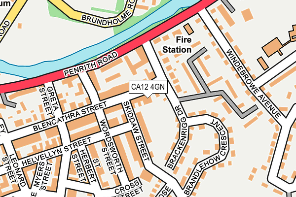
CA12 4GN lies on Blencathra Court in Keswick. CA12 4GN is located in the Keswick electoral ward, within the unitary authority of Cumberland and the English Parliamentary constituency of Copeland. The Sub Integrated Care Board (ICB) Location is NHS North East and North Cumbria ICB - 01H and the police force is Cumbria. This postcode has been in use since May 2004.


GetTheData
Source: OS OpenMap – Local (Ordnance Survey)
Source: OS VectorMap District (Ordnance Survey)
Licence: Open Government Licence (requires attribution)
| Easting | 327182 |
| Northing | 523480 |
| Latitude | 54.601223 |
| Longitude | -3.128695 |
GetTheData
Source: Open Postcode Geo
Licence: Open Government Licence
| Street | Blencathra Court |
| Town/City | Keswick |
| Country | England |
| Postcode District | CA12 |
| ➜ CA12 open data dashboard ➜ See where CA12 is on a map ➜ Where is Keswick? | |
GetTheData
Source: Land Registry Price Paid Data
Licence: Open Government Licence
Elevation or altitude of CA12 4GN as distance above sea level:
| Metres | Feet | |
|---|---|---|
| Elevation | 90m | 295ft |
Elevation is measured from the approximate centre of the postcode, to the nearest point on an OS contour line from OS Terrain 50, which has contour spacing of ten vertical metres.
➜ How high above sea level am I? Find the elevation of your current position using your device's GPS.
GetTheData
Source: Open Postcode Elevation
Licence: Open Government Licence
| Ward | Keswick |
| Constituency | Copeland |
GetTheData
Source: ONS Postcode Database
Licence: Open Government Licence
| May 2023 | Violence and sexual offences | On or near Leonard Street | 301m |
| March 2023 | Violence and sexual offences | On or near Leonard Street | 301m |
| March 2023 | Anti-social behaviour | On or near Leonard Street | 301m |
| ➜ Get more crime data in our Crime section | |||
GetTheData
Source: data.police.uk
Licence: Open Government Licence
| Fire Station (Penrith Road) | Keswick | 178m |
| Fire Station (Penrith Road) | Keswick | 194m |
| Greta Bank (Penrith Road) | Keswick | 284m |
| Cars Of The Stars (Bank Street) | Keswick | 415m |
| Twa Dogs Inn (Penrith Road) | Keswick | 475m |
GetTheData
Source: NaPTAN
Licence: Open Government Licence
| Percentage of properties with Next Generation Access | 100.0% |
| Percentage of properties with Superfast Broadband | 100.0% |
| Percentage of properties with Ultrafast Broadband | 0.0% |
| Percentage of properties with Full Fibre Broadband | 0.0% |
Superfast Broadband is between 30Mbps and 300Mbps
Ultrafast Broadband is > 300Mbps
| Percentage of properties unable to receive 2Mbps | 0.0% |
| Percentage of properties unable to receive 5Mbps | 0.0% |
| Percentage of properties unable to receive 10Mbps | 0.0% |
| Percentage of properties unable to receive 30Mbps | 0.0% |
GetTheData
Source: Ofcom
Licence: Ofcom Terms of Use (requires attribution)
GetTheData
Source: ONS Postcode Database
Licence: Open Government Licence


➜ Get more ratings from the Food Standards Agency
GetTheData
Source: Food Standards Agency
Licence: FSA terms & conditions
| Last Collection | |||
|---|---|---|---|
| Location | Mon-Fri | Sat | Distance |
| Millfield | 16:45 | 11:00 | 105m |
| Railway Station Keswick | 17:00 | 11:00 | 302m |
| Winderbrowe Avenue | 16:45 | 11:00 | 311m |
GetTheData
Source: Dracos
Licence: Creative Commons Attribution-ShareAlike
| Facility | Distance |
|---|---|
| Fitz Park Station Road, Keswick Grass Pitches, Outdoor Tennis Courts | 247m |
| St Herberts C Of E School Trinity Way, Keswick Grass Pitches | 343m |
| Keswick Leisure Centre Station Road, Keswick Swimming Pool, Health and Fitness Gym | 392m |
GetTheData
Source: Active Places
Licence: Open Government Licence
| School | Phase of Education | Distance |
|---|---|---|
| St Herbert's CofE (VA) Primary and Nursery School Trinity Way, Keswick, CA12 4HZ | Primary | 344m |
| Keswick School Vicarage Hill, Keswick, CA12 5QB | Secondary | 1.4km |
| Braithwaite CofE Primary School Braithwaite, Keswick, CA12 5TD | Primary | 4km |
GetTheData
Source: Edubase
Licence: Open Government Licence
The below table lists the International Territorial Level (ITL) codes (formerly Nomenclature of Territorial Units for Statistics (NUTS) codes) and Local Administrative Units (LAU) codes for CA12 4GN:
| ITL 1 Code | Name |
|---|---|
| TLD | North West (England) |
| ITL 2 Code | Name |
| TLD1 | Cumbria |
| ITL 3 Code | Name |
| TLD11 | West Cumbria |
| LAU 1 Code | Name |
| E07000026 | Allerdale |
GetTheData
Source: ONS Postcode Directory
Licence: Open Government Licence
The below table lists the Census Output Area (OA), Lower Layer Super Output Area (LSOA), and Middle Layer Super Output Area (MSOA) for CA12 4GN:
| Code | Name | |
|---|---|---|
| OA | E00096559 | |
| LSOA | E01019103 | Allerdale 012B |
| MSOA | E02003976 | Allerdale 012 |
GetTheData
Source: ONS Postcode Directory
Licence: Open Government Licence
| CA12 4HY | Blencathra Street | 22m |
| CA12 4HX | Blencathra Street | 58m |
| CA12 4BX | Skiddaw Street | 62m |
| CA12 4ER | Helvellyn Street | 78m |
| CA12 4HE | Catherine Cottages | 85m |
| CA12 4DA | Wordsworth Street | 91m |
| CA12 4JJ | Brackenrigg Drive | 97m |
| CA12 4HD | Rose Terrace | 104m |
| CA12 4BY | Skiddaw Street | 111m |
| CA12 4HA | Penrith Road | 124m |
GetTheData
Source: Open Postcode Geo; Land Registry Price Paid Data
Licence: Open Government Licence