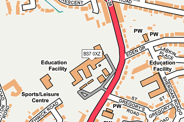
BS7 0XZ is located in the Horfield electoral ward, within the unitary authority of Bristol, City of and the English Parliamentary constituency of Bristol North West. The Sub Integrated Care Board (ICB) Location is NHS Bristol, North Somerset and South Gloucestershire ICB - 15C and the police force is Avon and Somerset. This postcode has been in use since January 1980.


GetTheData
Source: OS OpenMap – Local (Ordnance Survey)
Source: OS VectorMap District (Ordnance Survey)
Licence: Open Government Licence (requires attribution)
| Easting | 359825 |
| Northing | 178025 |
| Latitude | 51.499726 |
| Longitude | -2.580158 |
GetTheData
Source: Open Postcode Geo
Licence: Open Government Licence
| Country | England |
| Postcode District | BS7 |
| ➜ BS7 open data dashboard ➜ See where BS7 is on a map ➜ Where is Bristol? | |
GetTheData
Source: Land Registry Price Paid Data
Licence: Open Government Licence
Elevation or altitude of BS7 0XZ as distance above sea level:
| Metres | Feet | |
|---|---|---|
| Elevation | 80m | 262ft |
Elevation is measured from the approximate centre of the postcode, to the nearest point on an OS contour line from OS Terrain 50, which has contour spacing of ten vertical metres.
➜ How high above sea level am I? Find the elevation of your current position using your device's GPS.
GetTheData
Source: Open Postcode Elevation
Licence: Open Government Licence
| Ward | Horfield |
| Constituency | Bristol North West |
GetTheData
Source: ONS Postcode Database
Licence: Open Government Licence
| January 2024 | Violence and sexual offences | On or near Parking Area | 107m |
| January 2024 | Violence and sexual offences | On or near Parking Area | 107m |
| December 2023 | Other crime | On or near Parking Area | 107m |
| ➜ Get more crime data in our Crime section | |||
GetTheData
Source: data.police.uk
Licence: Open Government Licence
| Northville Road (Filton Road) | Filton | 173m |
| Filton Road | Horfield | 241m |
| Northville Road (Gloucester Road North) | Filton | 263m |
| Monk's Park Avenue | Southmead | 312m |
| Monk's Park Avenue | Southmead | 318m |
| Filton Abbey Wood Station | 1.4km |
| Bristol Parkway Station | 3.1km |
| Patchway Station | 3.2km |
GetTheData
Source: NaPTAN
Licence: Open Government Licence
GetTheData
Source: ONS Postcode Database
Licence: Open Government Licence


➜ Get more ratings from the Food Standards Agency
GetTheData
Source: Food Standards Agency
Licence: FSA terms & conditions
| Last Collection | |||
|---|---|---|---|
| Location | Mon-Fri | Sat | Distance |
| Northville Post Office | 17:15 | 12:30 | 173m |
| Hazel Grove | 16:00 | 12:15 | 346m |
| Boston Road | 17:30 | 11:30 | 430m |
GetTheData
Source: Dracos
Licence: Creative Commons Attribution-ShareAlike
| Facility | Distance |
|---|---|
| Orchard School Filton Road, Horfield, Bristol Grass Pitches, Sports Hall, Artificial Grass Pitch, Studio | 0m |
| Pyramid Youth Club Filton Avenue, Horfield, Bristol Sports Hall | 592m |
| Charborough Road Primary School Charborough Road, Charborough Road, Bristol Grass Pitches | 634m |
GetTheData
Source: Active Places
Licence: Open Government Licence
| School | Phase of Education | Distance |
|---|---|---|
| Orchard School Bristol Filton Road, Horfield, Bristol, BS7 0XZ | Secondary | 101m |
| Upper Horfield Primary School Upper Horfield Community School & Early Years, Sheridan Road, Horfield, Bristol, BS7 0PU | Primary | 245m |
| Charborough Road Primary School Charborough Road, Filton, Bristol, BS34 7RA | Primary | 634m |
GetTheData
Source: Edubase
Licence: Open Government Licence
The below table lists the International Territorial Level (ITL) codes (formerly Nomenclature of Territorial Units for Statistics (NUTS) codes) and Local Administrative Units (LAU) codes for BS7 0XZ:
| ITL 1 Code | Name |
|---|---|
| TLK | South West (England) |
| ITL 2 Code | Name |
| TLK1 | Gloucestershire, Wiltshire and Bath/Bristol area |
| ITL 3 Code | Name |
| TLK11 | Bristol, City of |
| LAU 1 Code | Name |
| E06000023 | Bristol, City of |
GetTheData
Source: ONS Postcode Directory
Licence: Open Government Licence
The below table lists the Census Output Area (OA), Lower Layer Super Output Area (LSOA), and Middle Layer Super Output Area (MSOA) for BS7 0XZ:
| Code | Name | |
|---|---|---|
| OA | E00073919 | |
| LSOA | E01014630 | Bristol 005A |
| MSOA | E02003016 | Bristol 005 |
GetTheData
Source: ONS Postcode Directory
Licence: Open Government Licence
| BS7 0PF | Filton Road | 113m |
| BS7 0PG | Filton Road | 134m |
| BS7 0SG | Gloucester Road North | 156m |
| BS7 0SF | Gloucester Road North | 178m |
| BS7 0TD | Braemar Crescent | 185m |
| BS7 0NF | St Gregorys Road | 219m |
| BS7 0PD | Filton Road | 228m |
| BS7 0UG | Northwick Road | 240m |
| BS7 0UQ | St Aldwyns Close | 242m |
| BS7 0TB | Braemar Avenue | 245m |
GetTheData
Source: Open Postcode Geo; Land Registry Price Paid Data
Licence: Open Government Licence