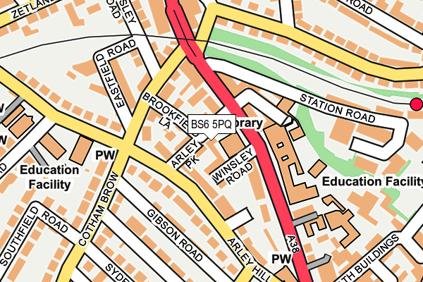
BS6 5PQ is located in the Cotham electoral ward, within the unitary authority of Bristol, City of and the English Parliamentary constituency of Bristol West. The Sub Integrated Care Board (ICB) Location is NHS Bristol, North Somerset and South Gloucestershire ICB - 15C and the police force is Avon and Somerset. This postcode has been in use since June 1998.


GetTheData
Source: OS OpenMap – Local (Ordnance Survey)
Source: OS VectorMap District (Ordnance Survey)
Licence: Open Government Licence (requires attribution)
| Easting | 358931 |
| Northing | 174488 |
| Latitude | 51.467860 |
| Longitude | -2.592624 |
GetTheData
Source: Open Postcode Geo
Licence: Open Government Licence
| Country | England |
| Postcode District | BS6 |
| ➜ BS6 open data dashboard ➜ See where BS6 is on a map ➜ Where is Bristol? | |
GetTheData
Source: Land Registry Price Paid Data
Licence: Open Government Licence
Elevation or altitude of BS6 5PQ as distance above sea level:
| Metres | Feet | |
|---|---|---|
| Elevation | 30m | 98ft |
Elevation is measured from the approximate centre of the postcode, to the nearest point on an OS contour line from OS Terrain 50, which has contour spacing of ten vertical metres.
➜ How high above sea level am I? Find the elevation of your current position using your device's GPS.
GetTheData
Source: Open Postcode Elevation
Licence: Open Government Licence
| Ward | Cotham |
| Constituency | Bristol West |
GetTheData
Source: ONS Postcode Database
Licence: Open Government Licence
6, BROOKFIELD ROAD, BRISTOL, BS6 5PQ 2020 13 NOV £150,000 |
GetTheData
Source: HM Land Registry Price Paid Data
Licence: Contains HM Land Registry data © Crown copyright and database right 2024. This data is licensed under the Open Government Licence v3.0.
| January 2024 | Public order | On or near Nine Tree Hill | 439m |
| January 2024 | Violence and sexual offences | On or near Nine Tree Hill | 439m |
| December 2023 | Burglary | On or near Nine Tree Hill | 439m |
| ➜ Get more crime data in our Crime section | |||
GetTheData
Source: data.police.uk
Licence: Open Government Licence
| Colstons School (Cheltenham Road) | Montpelier | 46m |
| Colstons School (Cheltenham Road) | Montpelier | 71m |
| Cromwell Road Arches (North Road) | Bishopston | 150m |
| Cromwell Road Arches (Cromwell Road) | Bishopston | 187m |
| Zetland Rd Jct (Cheltenham Road) | Bishopston | 198m |
| Montpelier Station | 0.3km |
| Redland Station | 0.5km |
| Clifton Down Station | 1.4km |
GetTheData
Source: NaPTAN
Licence: Open Government Licence
GetTheData
Source: ONS Postcode Database
Licence: Open Government Licence


➜ Get more ratings from the Food Standards Agency
GetTheData
Source: Food Standards Agency
Licence: FSA terms & conditions
| Last Collection | |||
|---|---|---|---|
| Location | Mon-Fri | Sat | Distance |
| Cheltenham Road | 17:00 | 12:15 | 60m |
| Cheltenham Road | 17:00 | 12:15 | 60m |
| Cotham Brow | 16:45 | 12:00 | 111m |
GetTheData
Source: Dracos
Licence: Creative Commons Attribution-ShareAlike
| Facility | Distance |
|---|---|
| Colstons Girls School Cheltenham Road, Bristol Sports Hall, Health and Fitness Gym, Studio | 98m |
| Bannatyne Health Club (Bristol) Redland Road, Bristol Swimming Pool, Health and Fitness Gym, Studio | 343m |
| Cotham Park Tennis Club Redland Road, Redland Road, Bristol Outdoor Tennis Courts | 361m |
GetTheData
Source: Active Places
Licence: Open Government Licence
| School | Phase of Education | Distance |
|---|---|---|
| Montpelier High School Cheltenham Road, Bristol, BS6 5RD | Secondary | 97m |
| The Dolphin School 25a Bath Buildings, Montpelier, Bristol, BS6 5PT | Primary | 226m |
| Cotham Gardens Primary School 18 Cotham Grove, Bristol, BS6 6AL | Primary | 440m |
GetTheData
Source: Edubase
Licence: Open Government Licence
The below table lists the International Territorial Level (ITL) codes (formerly Nomenclature of Territorial Units for Statistics (NUTS) codes) and Local Administrative Units (LAU) codes for BS6 5PQ:
| ITL 1 Code | Name |
|---|---|
| TLK | South West (England) |
| ITL 2 Code | Name |
| TLK1 | Gloucestershire, Wiltshire and Bath/Bristol area |
| ITL 3 Code | Name |
| TLK11 | Bristol, City of |
| LAU 1 Code | Name |
| E06000023 | Bristol, City of |
GetTheData
Source: ONS Postcode Directory
Licence: Open Government Licence
The below table lists the Census Output Area (OA), Lower Layer Super Output Area (LSOA), and Middle Layer Super Output Area (MSOA) for BS6 5PQ:
| Code | Name | |
|---|---|---|
| OA | E00073548 | |
| LSOA | E01014563 | Bristol 025D |
| MSOA | E02003036 | Bristol 025 |
GetTheData
Source: ONS Postcode Directory
Licence: Open Government Licence
| BS6 5QY | Winsley Road | 30m |
| BS6 5QX | Cheltenham Road | 30m |
| BS6 5PL | Arley Park | 35m |
| BS6 5PJ | Arley Hill | 52m |
| BS6 5RG | Cheltenham Crescent | 65m |
| BS6 5RB | Cheltenham Road | 70m |
| BS6 5PD | Brookfield Lane | 71m |
| BS6 5RA | Cheltenham Lane | 79m |
| BS6 5QZ | Cheltenham Road | 87m |
| BS6 6AE | Cotham Brow | 95m |
GetTheData
Source: Open Postcode Geo; Land Registry Price Paid Data
Licence: Open Government Licence