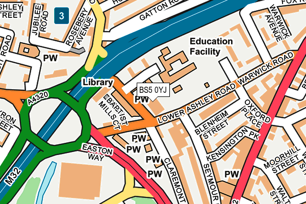
BS5 0YJ is located in the Lawrence Hill electoral ward, within the unitary authority of Bristol, City of and the English Parliamentary constituency of Bristol West. The Sub Integrated Care Board (ICB) Location is NHS Bristol, North Somerset and South Gloucestershire ICB - 15C and the police force is Avon and Somerset. This postcode has been in use since January 1980.


GetTheData
Source: OS OpenMap – Local (Ordnance Survey)
Source: OS VectorMap District (Ordnance Survey)
Licence: Open Government Licence (requires attribution)
| Easting | 360330 |
| Northing | 174285 |
| Latitude | 51.466135 |
| Longitude | -2.572462 |
GetTheData
Source: Open Postcode Geo
Licence: Open Government Licence
| Country | England |
| Postcode District | BS5 |
| ➜ BS5 open data dashboard ➜ See where BS5 is on a map ➜ Where is Bristol? | |
GetTheData
Source: Land Registry Price Paid Data
Licence: Open Government Licence
Elevation or altitude of BS5 0YJ as distance above sea level:
| Metres | Feet | |
|---|---|---|
| Elevation | 10m | 33ft |
Elevation is measured from the approximate centre of the postcode, to the nearest point on an OS contour line from OS Terrain 50, which has contour spacing of ten vertical metres.
➜ How high above sea level am I? Find the elevation of your current position using your device's GPS.
GetTheData
Source: Open Postcode Elevation
Licence: Open Government Licence
| Ward | Lawrence Hill |
| Constituency | Bristol West |
GetTheData
Source: ONS Postcode Database
Licence: Open Government Licence
| January 2024 | Anti-social behaviour | On or near Belmont Street | 340m |
| January 2024 | Vehicle crime | On or near Ashley Grove Road | 383m |
| December 2023 | Violence and sexual offences | On or near Belmont Street | 340m |
| ➜ Get more crime data in our Crime section | |||
GetTheData
Source: data.police.uk
Licence: Open Government Licence
| Villiers Road (Stapleton Road) | Easton | 242m |
| Villiers Road (Stapleton Road) | Eastville | 244m |
| Oxford Place (Warwick Road) | Easton | 251m |
| Oxford Place (Warwick Road) | Easton | 264m |
| Warwick Road (Stapleton Road) | Eastville | 268m |
| Stapleton Road Station | 0.5km |
| Lawrence Hill Station | 1.1km |
| Montpelier Station | 1.2km |
GetTheData
Source: NaPTAN
Licence: Open Government Licence
GetTheData
Source: ONS Postcode Database
Licence: Open Government Licence


➜ Get more ratings from the Food Standards Agency
GetTheData
Source: Food Standards Agency
Licence: FSA terms & conditions
| Last Collection | |||
|---|---|---|---|
| Location | Mon-Fri | Sat | Distance |
| Stapleton Roadpost Office | 17:00 | 11:30 | 249m |
| Roseberry Avenue | 17:00 | 11:45 | 255m |
| Mina Road Post Office | 17:00 | 11:45 | 420m |
GetTheData
Source: Dracos
Licence: Creative Commons Attribution-ShareAlike
| Facility | Distance |
|---|---|
| Evergreen Primary Academy Waverley Street, Bristol Grass Pitches | 53m |
| Empire Sports Club (Closed) Newfoundland Road, Bristol Health and Fitness Gym | 448m |
| St Barnabas Primary School Albany Road, Albany Road, Bristol Artificial Grass Pitch | 597m |
GetTheData
Source: Active Places
Licence: Open Government Licence
| School | Phase of Education | Distance |
|---|---|---|
| Evergreen Primary Academy Waverley Street, Easton, Bristol, BS5 0YR | Primary | 53m |
| St Werburgh's Primary School James Street, St Werburgh's, Bristol, BS2 9US | Primary | 506m |
| Bannerman Road Community Academy All Hallows Road, Easton, Bristol, BS5 0HR | Primary | 546m |
GetTheData
Source: Edubase
Licence: Open Government Licence
The below table lists the International Territorial Level (ITL) codes (formerly Nomenclature of Territorial Units for Statistics (NUTS) codes) and Local Administrative Units (LAU) codes for BS5 0YJ:
| ITL 1 Code | Name |
|---|---|
| TLK | South West (England) |
| ITL 2 Code | Name |
| TLK1 | Gloucestershire, Wiltshire and Bath/Bristol area |
| ITL 3 Code | Name |
| TLK11 | Bristol, City of |
| LAU 1 Code | Name |
| E06000023 | Bristol, City of |
GetTheData
Source: ONS Postcode Directory
Licence: Open Government Licence
The below table lists the Census Output Area (OA), Lower Layer Super Output Area (LSOA), and Middle Layer Super Output Area (MSOA) for BS5 0YJ:
| Code | Name | |
|---|---|---|
| OA | E00074011 | |
| LSOA | E01014654 | Bristol 056A |
| MSOA | E02006889 | Bristol 056 |
GetTheData
Source: ONS Postcode Directory
Licence: Open Government Licence
| BS5 0YN | Millpond Street | 30m |
| BS5 0YL | Lower Ashley Road | 51m |
| BS5 0FJ | Baptist Mills Court | 56m |
| BS5 0YW | Baptist Street | 65m |
| BS5 0UL | Claremont Street | 71m |
| BS5 0YP | Gable Road | 79m |
| BS5 0NS | Blenheim Street | 136m |
| BS5 0UW | Seymour Road | 164m |
| BS5 0UJ | Claremont Street | 171m |
| BS2 9TF | Gatton Road | 179m |
GetTheData
Source: Open Postcode Geo; Land Registry Price Paid Data
Licence: Open Government Licence