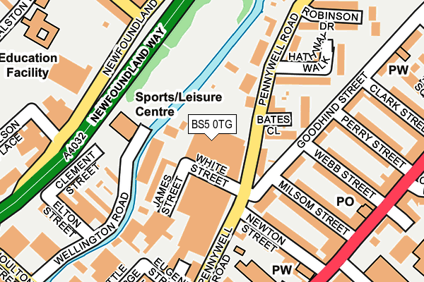
BS5 0TG is located in the Lawrence Hill electoral ward, within the unitary authority of Bristol, City of and the English Parliamentary constituency of Bristol West. The Sub Integrated Care Board (ICB) Location is NHS Bristol, North Somerset and South Gloucestershire ICB - 15C and the police force is Avon and Somerset. This postcode has been in use since August 1992.


GetTheData
Source: OS OpenMap – Local (Ordnance Survey)
Source: OS VectorMap District (Ordnance Survey)
Licence: Open Government Licence (requires attribution)
| Easting | 359964 |
| Northing | 173692 |
| Latitude | 51.460776 |
| Longitude | -2.577664 |
GetTheData
Source: Open Postcode Geo
Licence: Open Government Licence
| Country | England |
| Postcode District | BS5 |
➜ See where BS5 is on a map ➜ Where is Bristol? | |
GetTheData
Source: Land Registry Price Paid Data
Licence: Open Government Licence
Elevation or altitude of BS5 0TG as distance above sea level:
| Metres | Feet | |
|---|---|---|
| Elevation | 10m | 33ft |
Elevation is measured from the approximate centre of the postcode, to the nearest point on an OS contour line from OS Terrain 50, which has contour spacing of ten vertical metres.
➜ How high above sea level am I? Find the elevation of your current position using your device's GPS.
GetTheData
Source: Open Postcode Elevation
Licence: Open Government Licence
| Ward | Lawrence Hill |
| Constituency | Bristol West |
GetTheData
Source: ONS Postcode Database
Licence: Open Government Licence
| Thrissell Street (Stapleton Road) | Easton | 180m |
| Thrissell Street (Stapleton Road) | Easton | 232m |
| Lamb Street | Old Market | 326m |
| Armoury Square (Stapleton Road) | Easton | 342m |
| Armoury Square (Stapleton Road) | Easton | 356m |
| Lawrence Hill Station | 1km |
| Stapleton Road Station | 1.1km |
| Montpelier Station | 1.1km |
GetTheData
Source: NaPTAN
Licence: Open Government Licence
GetTheData
Source: ONS Postcode Database
Licence: Open Government Licence


➜ Get more ratings from the Food Standards Agency
GetTheData
Source: Food Standards Agency
Licence: FSA terms & conditions
| Last Collection | |||
|---|---|---|---|
| Location | Mon-Fri | Sat | Distance |
| Stapleton Road Post Office | 17:00 | 12:15 | 236m |
| Goodhind Street | 17:00 | 11:30 | 264m |
| Wade Street | 17:00 | 11:30 | 265m |
GetTheData
Source: Dracos
Licence: Creative Commons Attribution-ShareAlike
| Risk of BS5 0TG flooding from rivers and sea | Low |
| ➜ BS5 0TG flood map | |
GetTheData
Source: Open Flood Risk by Postcode
Licence: Open Government Licence
The below table lists the International Territorial Level (ITL) codes (formerly Nomenclature of Territorial Units for Statistics (NUTS) codes) and Local Administrative Units (LAU) codes for BS5 0TG:
| ITL 1 Code | Name |
|---|---|
| TLK | South West (England) |
| ITL 2 Code | Name |
| TLK1 | Gloucestershire, Wiltshire and Bath/Bristol area |
| ITL 3 Code | Name |
| TLK11 | Bristol, City of |
| LAU 1 Code | Name |
| E06000023 | Bristol, City of |
GetTheData
Source: ONS Postcode Directory
Licence: Open Government Licence
The below table lists the Census Output Area (OA), Lower Layer Super Output Area (LSOA), and Middle Layer Super Output Area (MSOA) for BS5 0TG:
| Code | Name | |
|---|---|---|
| OA | E00174253 | |
| LSOA | E01033358 | Bristol 054D |
| MSOA | E02006887 | Bristol 054 |
GetTheData
Source: ONS Postcode Directory
Licence: Open Government Licence
| BS5 0TS | White Street | 82m |
| BS5 0SR | Goodhind Street | 84m |
| BS5 0SN | Goodhind Street | 87m |
| BS5 0BF | Vestry Lane | 99m |
| BS5 0TJ | Pennywell Road | 117m |
| BS5 0QZ | Newton Street | 124m |
| BS5 0ST | Goodhind Street | 129m |
| BS5 0SS | Milsom Street | 158m |
| BS5 0QX | Stapleton Road | 169m |
| BS5 0UZ | Bates Close | 170m |
GetTheData
Source: Open Postcode Geo; Land Registry Price Paid Data
Licence: Open Government Licence