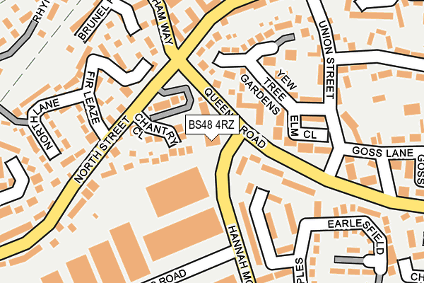
BS48 4RZ is located in the Nailsea West End electoral ward, within the unitary authority of North Somerset and the English Parliamentary constituency of North Somerset. The Sub Integrated Care Board (ICB) Location is NHS Bristol, North Somerset and South Gloucestershire ICB - 15C and the police force is Avon and Somerset. This postcode has been in use since December 1997.


GetTheData
Source: OS OpenMap – Local (Ordnance Survey)
Source: OS VectorMap District (Ordnance Survey)
Licence: Open Government Licence (requires attribution)
| Easting | 346097 |
| Northing | 170272 |
| Latitude | 51.428876 |
| Longitude | -2.776723 |
GetTheData
Source: Open Postcode Geo
Licence: Open Government Licence
| Country | England |
| Postcode District | BS48 |
| ➜ BS48 open data dashboard ➜ See where BS48 is on a map ➜ Where is Nailsea? | |
GetTheData
Source: Land Registry Price Paid Data
Licence: Open Government Licence
Elevation or altitude of BS48 4RZ as distance above sea level:
| Metres | Feet | |
|---|---|---|
| Elevation | 20m | 66ft |
Elevation is measured from the approximate centre of the postcode, to the nearest point on an OS contour line from OS Terrain 50, which has contour spacing of ten vertical metres.
➜ How high above sea level am I? Find the elevation of your current position using your device's GPS.
GetTheData
Source: Open Postcode Elevation
Licence: Open Government Licence
| Ward | Nailsea West End |
| Constituency | North Somerset |
GetTheData
Source: ONS Postcode Database
Licence: Open Government Licence
| January 2024 | Other crime | On or near Chapel Barton | 293m |
| August 2023 | Other crime | On or near The Maples | 196m |
| July 2023 | Other theft | On or near Chapel Barton | 293m |
| ➜ Get more crime data in our Crime section | |||
GetTheData
Source: data.police.uk
Licence: Open Government Licence
| The Co-op | Nailsea | 21m |
| The Co-op | Nailsea | 31m |
| Hannah Moore Road (Queens Road) | West End | 73m |
| Queens Road | West End | 77m |
| Union Street | West End | 155m |
| Nailsea & Backwell Station | 2.1km |
| Yatton Station | 5.5km |
GetTheData
Source: NaPTAN
Licence: Open Government Licence
GetTheData
Source: ONS Postcode Database
Licence: Open Government Licence


➜ Get more ratings from the Food Standards Agency
GetTheData
Source: Food Standards Agency
Licence: FSA terms & conditions
| Last Collection | |||
|---|---|---|---|
| Location | Mon-Fri | Sat | Distance |
| Engine Lane | 16:15 | 09:30 | 533m |
| Nailsea Post Office | 18:00 | 12:30 | 1,147m |
| West End | 17:00 | 08:00 | 1,771m |
GetTheData
Source: Dracos
Licence: Creative Commons Attribution-ShareAlike
| Facility | Distance |
|---|---|
| Nailsea And Backwell Rugby Club West End Lane, Nailsea, Bristol Grass Pitches | 553m |
| Nailsea And Tickenham Football Club Fryth Way, Nailsea Grass Pitches | 743m |
| Grove Sports Club St. Marys Grove, Nailsea, Bristol Sports Hall, Grass Pitches | 760m |
GetTheData
Source: Active Places
Licence: Open Government Licence
| School | Phase of Education | Distance |
|---|---|---|
| Grove Junior School Whiteoak Way, Nailsea, BS48 4YZ | Primary | 777m |
| Hannah More Infant School White Oak Way, Nailsea, BS48 4YZ | Primary | 825m |
| Kingshill Church School Pound Lane, Nailsea, BS48 2NP | Primary | 1.1km |
GetTheData
Source: Edubase
Licence: Open Government Licence
The below table lists the International Territorial Level (ITL) codes (formerly Nomenclature of Territorial Units for Statistics (NUTS) codes) and Local Administrative Units (LAU) codes for BS48 4RZ:
| ITL 1 Code | Name |
|---|---|
| TLK | South West (England) |
| ITL 2 Code | Name |
| TLK1 | Gloucestershire, Wiltshire and Bath/Bristol area |
| ITL 3 Code | Name |
| TLK12 | Bath and North East Somerset, North Somerset and South Gloucestershire |
| LAU 1 Code | Name |
| E06000024 | North Somerset |
GetTheData
Source: ONS Postcode Directory
Licence: Open Government Licence
The below table lists the Census Output Area (OA), Lower Layer Super Output Area (LSOA), and Middle Layer Super Output Area (MSOA) for BS48 4RZ:
| Code | Name | |
|---|---|---|
| OA | E00074661 | |
| LSOA | E01014783 | North Somerset 008D |
| MSOA | E02003072 | North Somerset 008 |
GetTheData
Source: ONS Postcode Directory
Licence: Open Government Licence
| BS48 4SX | North Street | 43m |
| BS48 4FN | Chantry Close | 77m |
| BS48 4SU | North Street | 90m |
| BS48 4RU | The Maples | 91m |
| BS48 4XP | Elm Close | 116m |
| BS48 4XS | Yew Tree Gardens | 132m |
| BS48 4XW | Yew Tree Gardens | 138m |
| BS48 4XN | Yew Tree Gardens | 148m |
| BS48 4RX | The Maples | 156m |
| BS48 4DH | Fir Leaze | 167m |
GetTheData
Source: Open Postcode Geo; Land Registry Price Paid Data
Licence: Open Government Licence