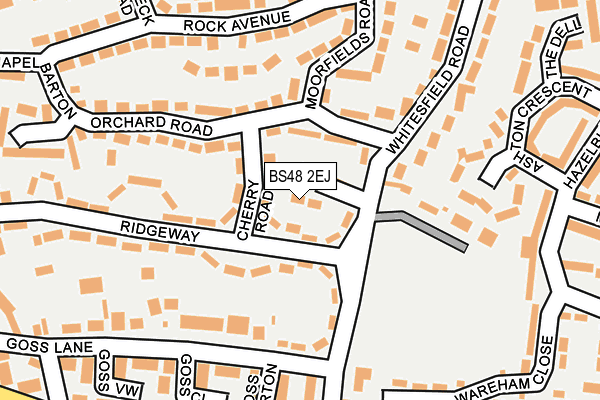
BS48 2EJ lies on Ivy Close in Nailsea, Bristol. BS48 2EJ is located in the Nailsea West End electoral ward, within the unitary authority of North Somerset and the English Parliamentary constituency of North Somerset. The Sub Integrated Care Board (ICB) Location is NHS Bristol, North Somerset and South Gloucestershire ICB - 15C and the police force is Avon and Somerset. This postcode has been in use since December 1997.


GetTheData
Source: OS OpenMap – Local (Ordnance Survey)
Source: OS VectorMap District (Ordnance Survey)
Licence: Open Government Licence (requires attribution)
| Easting | 346589 |
| Northing | 170403 |
| Latitude | 51.430100 |
| Longitude | -2.769667 |
GetTheData
Source: Open Postcode Geo
Licence: Open Government Licence
| Street | Ivy Close |
| Locality | Nailsea |
| Town/City | Bristol |
| Country | England |
| Postcode District | BS48 |
| ➜ BS48 open data dashboard ➜ See where BS48 is on a map ➜ Where is Nailsea? | |
GetTheData
Source: Land Registry Price Paid Data
Licence: Open Government Licence
Elevation or altitude of BS48 2EJ as distance above sea level:
| Metres | Feet | |
|---|---|---|
| Elevation | 20m | 66ft |
Elevation is measured from the approximate centre of the postcode, to the nearest point on an OS contour line from OS Terrain 50, which has contour spacing of ten vertical metres.
➜ How high above sea level am I? Find the elevation of your current position using your device's GPS.
GetTheData
Source: Open Postcode Elevation
Licence: Open Government Licence
| Ward | Nailsea West End |
| Constituency | North Somerset |
GetTheData
Source: ONS Postcode Database
Licence: Open Government Licence
| January 2024 | Other crime | On or near Chapel Barton | 294m |
| August 2023 | Other crime | On or near The Maples | 491m |
| July 2023 | Other theft | On or near Chapel Barton | 294m |
| ➜ Get more crime data in our Crime section | |||
GetTheData
Source: data.police.uk
Licence: Open Government Licence
| Whitesfield Road | Nailsea | 122m |
| Goss Lane | Nailsea | 180m |
| Whitesfield Road | West End | 242m |
| Trinity Road (Queens Road) | West End | 255m |
| Fosse Lane | Stone-edge Batch | 298m |
| Nailsea & Backwell Station | 1.8km |
| Yatton Station | 5.9km |
GetTheData
Source: NaPTAN
Licence: Open Government Licence
| Percentage of properties with Next Generation Access | 100.0% |
| Percentage of properties with Superfast Broadband | 100.0% |
| Percentage of properties with Ultrafast Broadband | 0.0% |
| Percentage of properties with Full Fibre Broadband | 0.0% |
Superfast Broadband is between 30Mbps and 300Mbps
Ultrafast Broadband is > 300Mbps
| Percentage of properties unable to receive 2Mbps | 0.0% |
| Percentage of properties unable to receive 5Mbps | 0.0% |
| Percentage of properties unable to receive 10Mbps | 0.0% |
| Percentage of properties unable to receive 30Mbps | 0.0% |
GetTheData
Source: Ofcom
Licence: Ofcom Terms of Use (requires attribution)
GetTheData
Source: ONS Postcode Database
Licence: Open Government Licence


➜ Get more ratings from the Food Standards Agency
GetTheData
Source: Food Standards Agency
Licence: FSA terms & conditions
| Last Collection | |||
|---|---|---|---|
| Location | Mon-Fri | Sat | Distance |
| Nailsea Post Office | 18:00 | 12:30 | 638m |
| Engine Lane | 16:15 | 09:30 | 926m |
| Trendlewood | 17:00 | 09:00 | 1,670m |
GetTheData
Source: Dracos
Licence: Creative Commons Attribution-ShareAlike
| Facility | Distance |
|---|---|
| Mizzymead Recreation Centre & Social Club Mizzymead Rise, Nailsea, Bristol Indoor Bowls, Outdoor Tennis Courts | 501m |
| Grove Junior School White Oak Way, Nailsea, Bristol Grass Pitches | 587m |
| Grove Sports Club St. Marys Grove, Nailsea, Bristol Sports Hall, Grass Pitches | 703m |
GetTheData
Source: Active Places
Licence: Open Government Licence
| School | Phase of Education | Distance |
|---|---|---|
| Grove Junior School Whiteoak Way, Nailsea, BS48 4YZ | Primary | 598m |
| Hannah More Infant School White Oak Way, Nailsea, BS48 4YZ | Primary | 625m |
| Kingshill Church School Pound Lane, Nailsea, BS48 2NP | Primary | 791m |
GetTheData
Source: Edubase
Licence: Open Government Licence
The below table lists the International Territorial Level (ITL) codes (formerly Nomenclature of Territorial Units for Statistics (NUTS) codes) and Local Administrative Units (LAU) codes for BS48 2EJ:
| ITL 1 Code | Name |
|---|---|
| TLK | South West (England) |
| ITL 2 Code | Name |
| TLK1 | Gloucestershire, Wiltshire and Bath/Bristol area |
| ITL 3 Code | Name |
| TLK12 | Bath and North East Somerset, North Somerset and South Gloucestershire |
| LAU 1 Code | Name |
| E06000024 | North Somerset |
GetTheData
Source: ONS Postcode Directory
Licence: Open Government Licence
The below table lists the Census Output Area (OA), Lower Layer Super Output Area (LSOA), and Middle Layer Super Output Area (MSOA) for BS48 2EJ:
| Code | Name | |
|---|---|---|
| OA | E00074685 | |
| LSOA | E01014781 | North Somerset 008B |
| MSOA | E02003072 | North Somerset 008 |
GetTheData
Source: ONS Postcode Directory
Licence: Open Government Licence
| BS48 2EQ | Ridgeway | 40m |
| BS48 2EE | Cherry Road | 62m |
| BS48 2DZ | Orchard Road | 70m |
| BS48 2EH | Whitesfield Road | 129m |
| BS48 2DY | Whitesfield Road | 142m |
| BS48 2AL | Lion Close | 146m |
| BS48 2EA | Orchard Road | 155m |
| BS48 2AP | Moorfields Road | 165m |
| BS48 2JS | Vale End | 181m |
| BS48 4NF | Whitesfield Road | 185m |
GetTheData
Source: Open Postcode Geo; Land Registry Price Paid Data
Licence: Open Government Licence