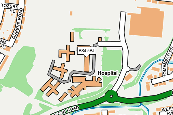
BS4 5BJ is located in the Brislington West electoral ward, within the unitary authority of Bristol, City of and the English Parliamentary constituency of Bristol East. The Sub Integrated Care Board (ICB) Location is NHS Bristol, North Somerset and South Gloucestershire ICB - 15C and the police force is Avon and Somerset. This postcode has been in use since June 2004.


GetTheData
Source: OS OpenMap – Local (Ordnance Survey)
Source: OS VectorMap District (Ordnance Survey)
Licence: Open Government Licence (requires attribution)
| Easting | 361336 |
| Northing | 170399 |
| Latitude | 51.431265 |
| Longitude | -2.557555 |
GetTheData
Source: Open Postcode Geo
Licence: Open Government Licence
| Country | England |
| Postcode District | BS4 |
| ➜ BS4 open data dashboard ➜ See where BS4 is on a map ➜ Where is Bristol? | |
GetTheData
Source: Land Registry Price Paid Data
Licence: Open Government Licence
Elevation or altitude of BS4 5BJ as distance above sea level:
| Metres | Feet | |
|---|---|---|
| Elevation | 30m | 98ft |
Elevation is measured from the approximate centre of the postcode, to the nearest point on an OS contour line from OS Terrain 50, which has contour spacing of ten vertical metres.
➜ How high above sea level am I? Find the elevation of your current position using your device's GPS.
GetTheData
Source: Open Postcode Elevation
Licence: Open Government Licence
| Ward | Brislington West |
| Constituency | Bristol East |
GetTheData
Source: ONS Postcode Database
Licence: Open Government Licence
| January 2024 | Criminal damage and arson | On or near Tozers Hill | 315m |
| January 2024 | Vehicle crime | On or near Tozers Hill | 315m |
| July 2023 | Violence and sexual offences | On or near Tozers Hill | 315m |
| ➜ Get more crime data in our Crime section | |||
GetTheData
Source: data.police.uk
Licence: Open Government Licence
| Tesco Brislington | Brislington | 142m |
| Lodway Road (Talbot Road) | Knowle | 309m |
| Lodway Road (Talbot Road) | Knowle | 319m |
| Callington Road | Brislington | 384m |
| West Town Park (West Town Lane) | Brislington | 384m |
| Bristol Temple Meads Station | 2.6km |
| Bedminster Station | 2.7km |
| Lawrence Hill Station | 3km |
GetTheData
Source: NaPTAN
Licence: Open Government Licence
GetTheData
Source: ONS Postcode Database
Licence: Open Government Licence


➜ Get more ratings from the Food Standards Agency
GetTheData
Source: Food Standards Agency
Licence: FSA terms & conditions
| Last Collection | |||
|---|---|---|---|
| Location | Mon-Fri | Sat | Distance |
| Tesco | 17:00 | 12:30 | 193m |
| Water Lane | 17:15 | 12:45 | 393m |
| Talbot/Jubilee Road | 16:00 | 11:30 | 432m |
GetTheData
Source: Dracos
Licence: Creative Commons Attribution-ShareAlike
| Facility | Distance |
|---|---|
| Jubilee Swimming Pool (Bristol) Jubilee Road, Knowle, Bristol Swimming Pool, Health and Fitness Gym | 385m |
| St Martins Church Hall St. Martins Road, Bristol Sports Hall | 443m |
| Crescent Lawn Tennis Club Kensington Park Road, Brislington, Bristol Outdoor Tennis Courts | 496m |
GetTheData
Source: Active Places
Licence: Open Government Licence
| School | Phase of Education | Distance |
|---|---|---|
| West Town Lane Academy West Town Lane, Brislington, Bristol, BS4 5DT | Primary | 439m |
| Holymead Primary School Hollywood Road, Brislington, Bristol, BS4 4LE | Primary | 833m |
| Cleve House School 254 Wells Road, Knowle, Bristol, BS4 2PN | Not applicable | 1km |
GetTheData
Source: Edubase
Licence: Open Government Licence
The below table lists the International Territorial Level (ITL) codes (formerly Nomenclature of Territorial Units for Statistics (NUTS) codes) and Local Administrative Units (LAU) codes for BS4 5BJ:
| ITL 1 Code | Name |
|---|---|
| TLK | South West (England) |
| ITL 2 Code | Name |
| TLK1 | Gloucestershire, Wiltshire and Bath/Bristol area |
| ITL 3 Code | Name |
| TLK11 | Bristol, City of |
| LAU 1 Code | Name |
| E06000023 | Bristol, City of |
GetTheData
Source: ONS Postcode Directory
Licence: Open Government Licence
The below table lists the Census Output Area (OA), Lower Layer Super Output Area (LSOA), and Middle Layer Super Output Area (MSOA) for BS4 5BJ:
| Code | Name | |
|---|---|---|
| OA | E00073411 | |
| LSOA | E01014534 | Bristol 043B |
| MSOA | E02003054 | Bristol 043 |
GetTheData
Source: ONS Postcode Directory
Licence: Open Government Licence
| BS4 5DP | Lanes End | 242m |
| BS4 5AP | Homemead Drive | 262m |
| BS4 2LT | Queens Road | 273m |
| BS4 5DJ | Hither Bath Bridge | 278m |
| BS4 2LU | Queens Road | 290m |
| BS4 2NT | Talbot Road | 297m |
| BS4 5AT | Gotley Road | 303m |
| BS4 2NW | Talbot Road | 312m |
| BS4 2LS | King Road | 314m |
| BS4 2JU | Tozers Hill | 325m |
GetTheData
Source: Open Postcode Geo; Land Registry Price Paid Data
Licence: Open Government Licence