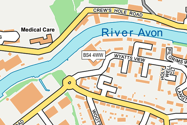
BS4 4WW is located in the Brislington East electoral ward, within the unitary authority of Bristol, City of and the English Parliamentary constituency of Bristol East. The Sub Integrated Care Board (ICB) Location is NHS Bristol, North Somerset and South Gloucestershire ICB - 15C and the police force is Avon and Somerset. This postcode has been in use since June 1996.


GetTheData
Source: OS OpenMap – Local (Ordnance Survey)
Source: OS VectorMap District (Ordnance Survey)
Licence: Open Government Licence (requires attribution)
| Easting | 362229 |
| Northing | 172996 |
| Latitude | 51.454674 |
| Longitude | -2.544988 |
GetTheData
Source: Open Postcode Geo
Licence: Open Government Licence
| Country | England |
| Postcode District | BS4 |
➜ See where BS4 is on a map ➜ Where is Bristol? | |
GetTheData
Source: Land Registry Price Paid Data
Licence: Open Government Licence
Elevation or altitude of BS4 4WW as distance above sea level:
| Metres | Feet | |
|---|---|---|
| Elevation | 10m | 33ft |
Elevation is measured from the approximate centre of the postcode, to the nearest point on an OS contour line from OS Terrain 50, which has contour spacing of ten vertical metres.
➜ How high above sea level am I? Find the elevation of your current position using your device's GPS.
GetTheData
Source: Open Postcode Elevation
Licence: Open Government Licence
| Ward | Brislington East |
| Constituency | Bristol East |
GetTheData
Source: ONS Postcode Database
Licence: Open Government Licence
| Chapel Way (St Anne's Road) | St Anne's Park | 171m |
| Wootton Crescent (Wootton Road) | St Anne's Park | 192m |
| Chapel Way (St Anne's Road) | St Anne's Park | 214m |
| Wootton Crescent (Wootton Road) | St Anne's Park | 221m |
| Langton Court Road (Newbridge Road) | St Anne's | 449m |
| Lawrence Hill Station | 1.4km |
| Stapleton Road Station | 2.1km |
| Bristol Temple Meads Station | 2.6km |
GetTheData
Source: NaPTAN
Licence: Open Government Licence
GetTheData
Source: ONS Postcode Database
Licence: Open Government Licence


➜ Get more ratings from the Food Standards Agency
GetTheData
Source: Food Standards Agency
Licence: FSA terms & conditions
| Last Collection | |||
|---|---|---|---|
| Location | Mon-Fri | Sat | Distance |
| Boardmills Shops | 17:00 | 10:45 | 18m |
| Church Road | 16:00 | 12:00 | 569m |
| Crews Hole Road | 17:00 | 12:15 | 614m |
GetTheData
Source: Dracos
Licence: Creative Commons Attribution-ShareAlike
| Risk of BS4 4WW flooding from rivers and sea | Low |
| ➜ BS4 4WW flood map | |
GetTheData
Source: Open Flood Risk by Postcode
Licence: Open Government Licence
The below table lists the International Territorial Level (ITL) codes (formerly Nomenclature of Territorial Units for Statistics (NUTS) codes) and Local Administrative Units (LAU) codes for BS4 4WW:
| ITL 1 Code | Name |
|---|---|
| TLK | South West (England) |
| ITL 2 Code | Name |
| TLK1 | Gloucestershire, Wiltshire and Bath/Bristol area |
| ITL 3 Code | Name |
| TLK11 | Bristol, City of |
| LAU 1 Code | Name |
| E06000023 | Bristol, City of |
GetTheData
Source: ONS Postcode Directory
Licence: Open Government Licence
The below table lists the Census Output Area (OA), Lower Layer Super Output Area (LSOA), and Middle Layer Super Output Area (MSOA) for BS4 4WW:
| Code | Name | |
|---|---|---|
| OA | E00073348 | |
| LSOA | E01014528 | Bristol 035A |
| MSOA | E02003046 | Bristol 035 |
GetTheData
Source: ONS Postcode Directory
Licence: Open Government Licence
| BS4 4DQ | Whiteway Close | 88m |
| BS4 4RH | Riverside Steps | 93m |
| BS4 4EY | The Stepping Stones | 96m |
| BS4 4DG | Burgess Green Close | 162m |
| BS4 4AL | Wootton Road | 170m |
| BS4 4DX | Roegate Drive | 185m |
| BS4 4AP | Wootton Road | 214m |
| BS4 4AW | Wootton Crescent | 224m |
| BS4 4AN | Wootton Crescent | 250m |
| BS4 4HY | Holy Well Close | 252m |
GetTheData
Source: Open Postcode Geo; Land Registry Price Paid Data
Licence: Open Government Licence