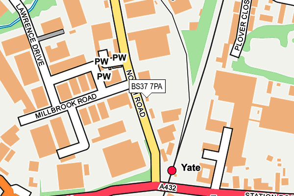
BS37 7PA lies on North Road in Yate, Bristol. BS37 7PA is located in the Frampton Cotterell electoral ward, within the unitary authority of South Gloucestershire and the English Parliamentary constituency of Thornbury and Yate. The Sub Integrated Care Board (ICB) Location is NHS Bristol, North Somerset and South Gloucestershire ICB - 15C and the police force is Avon and Somerset. This postcode has been in use since December 1997.


GetTheData
Source: OS OpenMap – Local (Ordnance Survey)
Source: OS VectorMap District (Ordnance Survey)
Licence: Open Government Licence (requires attribution)
| Easting | 370072 |
| Northing | 182721 |
| Latitude | 51.542585 |
| Longitude | -2.432943 |
GetTheData
Source: Open Postcode Geo
Licence: Open Government Licence
| Street | North Road |
| Locality | Yate |
| Town/City | Bristol |
| Country | England |
| Postcode District | BS37 |
| ➜ BS37 open data dashboard ➜ See where BS37 is on a map ➜ Where is Yate? | |
GetTheData
Source: Land Registry Price Paid Data
Licence: Open Government Licence
Elevation or altitude of BS37 7PA as distance above sea level:
| Metres | Feet | |
|---|---|---|
| Elevation | 70m | 230ft |
Elevation is measured from the approximate centre of the postcode, to the nearest point on an OS contour line from OS Terrain 50, which has contour spacing of ten vertical metres.
➜ How high above sea level am I? Find the elevation of your current position using your device's GPS.
GetTheData
Source: Open Postcode Elevation
Licence: Open Government Licence
| Ward | Frampton Cotterell |
| Constituency | Thornbury And Yate |
GetTheData
Source: ONS Postcode Database
Licence: Open Government Licence
24A, NORTH ROAD, YATE, BRISTOL, BS37 7PA 2008 2 MAY £80,000 |
GetTheData
Source: HM Land Registry Price Paid Data
Licence: Contains HM Land Registry data © Crown copyright and database right 2024. This data is licensed under the Open Government Licence v3.0.
| December 2023 | Burglary | On or near Parking Area | 482m |
| October 2023 | Anti-social behaviour | On or near Parking Area | 482m |
| July 2023 | Burglary | On or near Westleigh Close | 335m |
| ➜ Get more crime data in our Crime section | |||
GetTheData
Source: data.police.uk
Licence: Open Government Licence
| Stover Road (Badminton Road) | Yate | 255m |
| Yate Station (Station Road) | Yate | 255m |
| Yate Station (Station Road) | Yate | 267m |
| Waverley Road (Stover Road) | Yate | 364m |
| Waverley Road (Stover Road) | Yate | 380m |
| Yate Station | 0.2km |
GetTheData
Source: NaPTAN
Licence: Open Government Licence
GetTheData
Source: ONS Postcode Database
Licence: Open Government Licence


➜ Get more ratings from the Food Standards Agency
GetTheData
Source: Food Standards Agency
Licence: FSA terms & conditions
| Last Collection | |||
|---|---|---|---|
| Location | Mon-Fri | Sat | Distance |
| Westerleigh Close | 16:15 | 09:15 | 260m |
| Stover Trading Estate | 18:30 | 286m | |
| Waverley Road | 16:45 | 08:00 | 538m |
GetTheData
Source: Dracos
Licence: Creative Commons Attribution-ShareAlike
| Facility | Distance |
|---|---|
| Sunnyside Lane Playing Field Moorland Road, Yate, Bristol Grass Pitches, Outdoor Tennis Courts | 568m |
| Moorland Road Methodist Church Hall Moorland Road, Yate, Bristol Sports Hall | 584m |
| Yate Town Football Club Lodge Road, Yate, Bristol Grass Pitches | 782m |
GetTheData
Source: Active Places
Licence: Open Government Licence
| School | Phase of Education | Distance |
|---|---|---|
| Vinney Green Secure Unit Care of: South Gloucestershire Council, Badminton Road, Yate, Bristol, BS37 5AF | Not applicable | 471m |
| Tyndale Primary School Tyndale Avenue, Yate, BS37 5EX | Primary | 780m |
| North Road Community Primary School North Road, Yate, Bristol, BS37 7LQ | Primary | 1km |
GetTheData
Source: Edubase
Licence: Open Government Licence
The below table lists the International Territorial Level (ITL) codes (formerly Nomenclature of Territorial Units for Statistics (NUTS) codes) and Local Administrative Units (LAU) codes for BS37 7PA:
| ITL 1 Code | Name |
|---|---|
| TLK | South West (England) |
| ITL 2 Code | Name |
| TLK1 | Gloucestershire, Wiltshire and Bath/Bristol area |
| ITL 3 Code | Name |
| TLK12 | Bath and North East Somerset, North Somerset and South Gloucestershire |
| LAU 1 Code | Name |
| E06000025 | South Gloucestershire |
GetTheData
Source: ONS Postcode Directory
Licence: Open Government Licence
The below table lists the Census Output Area (OA), Lower Layer Super Output Area (LSOA), and Middle Layer Super Output Area (MSOA) for BS37 7PA:
| Code | Name | |
|---|---|---|
| OA | E00075758 | |
| LSOA | E01014994 | South Gloucestershire 019D |
| MSOA | E02003108 | South Gloucestershire 019 |
GetTheData
Source: ONS Postcode Directory
Licence: Open Government Licence
| BS37 7PW | North Road | 122m |
| BS37 7PL | Chapel Orchard | 133m |
| BS37 5HZ | Badminton Court | 201m |
| BS37 5HT | Station Road | 223m |
| BS37 7PR | North Road | 247m |
| BS37 5XU | Plover Close | 248m |
| BS37 4PS | Station Road | 268m |
| BS37 5HX | Badminton Road | 323m |
| BS37 5XS | Parnall Crescent | 360m |
| BS37 4PR | Westleigh Close | 367m |
GetTheData
Source: Open Postcode Geo; Land Registry Price Paid Data
Licence: Open Government Licence