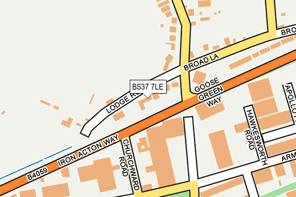
BS37 7LE lies on Lodge Road in Yate, Bristol. BS37 7LE is located in the Frampton Cotterell electoral ward, within the unitary authority of South Gloucestershire and the English Parliamentary constituency of Thornbury and Yate. The Sub Integrated Care Board (ICB) Location is NHS Bristol, North Somerset and South Gloucestershire ICB - 15C and the police force is Avon and Somerset. This postcode has been in use since December 1997.


GetTheData
Source: OS OpenMap – Local (Ordnance Survey)
Source: OS VectorMap District (Ordnance Survey)
Licence: Open Government Licence (requires attribution)
| Easting | 369848 |
| Northing | 183452 |
| Latitude | 51.549146 |
| Longitude | -2.436237 |
GetTheData
Source: Open Postcode Geo
Licence: Open Government Licence
| Street | Lodge Road |
| Locality | Yate |
| Town/City | Bristol |
| Country | England |
| Postcode District | BS37 |
➜ See where BS37 is on a map ➜ Where is Yate? | |
GetTheData
Source: Land Registry Price Paid Data
Licence: Open Government Licence
Elevation or altitude of BS37 7LE as distance above sea level:
| Metres | Feet | |
|---|---|---|
| Elevation | 70m | 230ft |
Elevation is measured from the approximate centre of the postcode, to the nearest point on an OS contour line from OS Terrain 50, which has contour spacing of ten vertical metres.
➜ How high above sea level am I? Find the elevation of your current position using your device's GPS.
GetTheData
Source: Open Postcode Elevation
Licence: Open Government Licence
| Ward | Frampton Cotterell |
| Constituency | Thornbury And Yate |
GetTheData
Source: ONS Postcode Database
Licence: Open Government Licence
42, LODGE ROAD, YATE, BRISTOL, BS37 7LE 2022 2 DEC £795,000 |
3, LODGE ROAD, YATE, BRISTOL, BS37 7LE 2017 6 JUN £375,000 |
5, LODGE ROAD, YATE, BRISTOL, BS37 7LE 2002 11 APR £188,000 |
5, LODGE ROAD, YATE, BRISTOL, BS37 7LE 1998 6 JAN £99,000 |
5, LODGE ROAD, YATE, BRISTOL, BS37 7LE 1995 23 MAY £73,000 |
GetTheData
Source: HM Land Registry Price Paid Data
Licence: Contains HM Land Registry data © Crown copyright and database right 2025. This data is licensed under the Open Government Licence v3.0.
| North Road (Goose Green Way) | Yate | 108m |
| North Road (Goose Green Way) | Yate | 121m |
| Broad Lane (North Road) | Engine Common | 141m |
| Broad Lane (North Road) | Engine Common | 146m |
| Armstrong Way (Iron Acton Way) | Yate | 439m |
| Yate Station | 1km |
GetTheData
Source: NaPTAN
Licence: Open Government Licence
| Percentage of properties with Next Generation Access | 100.0% |
| Percentage of properties with Superfast Broadband | 100.0% |
| Percentage of properties with Ultrafast Broadband | 0.0% |
| Percentage of properties with Full Fibre Broadband | 0.0% |
Superfast Broadband is between 30Mbps and 300Mbps
Ultrafast Broadband is > 300Mbps
| Median download speed | 55.0Mbps |
| Average download speed | 50.6Mbps |
| Maximum download speed | 80.00Mbps |
| Median upload speed | 10.0Mbps |
| Average upload speed | 11.5Mbps |
| Maximum upload speed | 20.00Mbps |
| Percentage of properties unable to receive 2Mbps | 0.0% |
| Percentage of properties unable to receive 5Mbps | 0.0% |
| Percentage of properties unable to receive 10Mbps | 0.0% |
| Percentage of properties unable to receive 30Mbps | 0.0% |
GetTheData
Source: Ofcom
Licence: Ofcom Terms of Use (requires attribution)
Estimated total energy consumption in BS37 7LE by fuel type, 2015.
| Consumption (kWh) | 59,338 |
|---|---|
| Meter count | 8 |
| Mean (kWh/meter) | 7,417 |
| Median (kWh/meter) | 7,094 |
GetTheData
Source: Postcode level gas estimates: 2015 (experimental)
Source: Postcode level electricity estimates: 2015 (experimental)
Licence: Open Government Licence
GetTheData
Source: ONS Postcode Database
Licence: Open Government Licence


➜ Get more ratings from the Food Standards Agency
GetTheData
Source: Food Standards Agency
Licence: FSA terms & conditions
| Last Collection | |||
|---|---|---|---|
| Location | Mon-Fri | Sat | Distance |
| Dean Road (Yate) | 16:45 | 09:00 | 233m |
| North Road Post Office | 17:00 | 11:00 | 278m |
| Stover Trading Estate | 18:30 | 575m | |
GetTheData
Source: Dracos
Licence: Creative Commons Attribution-ShareAlike
The below table lists the International Territorial Level (ITL) codes (formerly Nomenclature of Territorial Units for Statistics (NUTS) codes) and Local Administrative Units (LAU) codes for BS37 7LE:
| ITL 1 Code | Name |
|---|---|
| TLK | South West (England) |
| ITL 2 Code | Name |
| TLK1 | Gloucestershire, Wiltshire and Bath/Bristol area |
| ITL 3 Code | Name |
| TLK12 | Bath and North East Somerset, North Somerset and South Gloucestershire |
| LAU 1 Code | Name |
| E06000025 | South Gloucestershire |
GetTheData
Source: ONS Postcode Directory
Licence: Open Government Licence
The below table lists the Census Output Area (OA), Lower Layer Super Output Area (LSOA), and Middle Layer Super Output Area (MSOA) for BS37 7LE:
| Code | Name | |
|---|---|---|
| OA | E00075432 | |
| LSOA | E01014929 | South Gloucestershire 003C |
| MSOA | E02003092 | South Gloucestershire 003 |
GetTheData
Source: ONS Postcode Directory
Licence: Open Government Licence
| BS37 5NG | Armstrong Way | 193m |
| BS37 7LD | Broad Lane | 194m |
| BS37 7LG | North Road | 204m |
| BS37 7BE | Broad Lane | 240m |
| BS37 5NJ | Dean Court | 269m |
| BS37 7LH | The British | 374m |
| BS37 9XT | Dyers Lane | 394m |
| BS37 7LQ | North Road | 397m |
| BS37 5NH | Dean Road | 404m |
| BS37 5NA | The Oaklands Business Park | 498m |
GetTheData
Source: Open Postcode Geo; Land Registry Price Paid Data
Licence: Open Government Licence