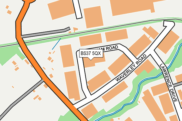
BS37 5QX is located in the Frampton Cotterell electoral ward, within the unitary authority of South Gloucestershire and the English Parliamentary constituency of Thornbury and Yate. The Sub Integrated Care Board (ICB) Location is NHS Bristol, North Somerset and South Gloucestershire ICB - 15C and the police force is Avon and Somerset. This postcode has been in use since December 1997.


GetTheData
Source: OS OpenMap – Local (Ordnance Survey)
Source: OS VectorMap District (Ordnance Survey)
Licence: Open Government Licence (requires attribution)
| Easting | 369578 |
| Northing | 182924 |
| Latitude | 51.544385 |
| Longitude | -2.440085 |
GetTheData
Source: Open Postcode Geo
Licence: Open Government Licence
| Country | England |
| Postcode District | BS37 |
| ➜ BS37 open data dashboard ➜ See where BS37 is on a map ➜ Where is Yate? | |
GetTheData
Source: Land Registry Price Paid Data
Licence: Open Government Licence
Elevation or altitude of BS37 5QX as distance above sea level:
| Metres | Feet | |
|---|---|---|
| Elevation | 70m | 230ft |
Elevation is measured from the approximate centre of the postcode, to the nearest point on an OS contour line from OS Terrain 50, which has contour spacing of ten vertical metres.
➜ How high above sea level am I? Find the elevation of your current position using your device's GPS.
GetTheData
Source: Open Postcode Elevation
Licence: Open Government Licence
| Ward | Frampton Cotterell |
| Constituency | Thornbury And Yate |
GetTheData
Source: ONS Postcode Database
Licence: Open Government Licence
| June 2022 | Vehicle crime | On or near Waverley Road | 126m |
| June 2022 | Vehicle crime | On or near Iron Acton Way | 390m |
| June 2022 | Burglary | On or near Hope Road | 410m |
| ➜ Get more crime data in our Crime section | |||
GetTheData
Source: data.police.uk
Licence: Open Government Licence
| Armstrong Way (Iron Acton Way) | Yate | 318m |
| Armstrong Way (Iron Acton Way) | Yate | 329m |
| Waverley Road (Stover Road) | Yate | 375m |
| Waverley Road (Stover Road) | Yate | 382m |
| Stover Road (Badminton Road) | Yate | 472m |
| Yate Station | 0.7km |
GetTheData
Source: NaPTAN
Licence: Open Government Licence
| Median download speed | 56.5Mbps |
| Average download speed | 55.1Mbps |
| Maximum download speed | 72.18Mbps |
| Median upload speed | 8.5Mbps |
| Average upload speed | 10.1Mbps |
| Maximum upload speed | 15.77Mbps |
GetTheData
Source: Ofcom
Licence: Ofcom Terms of Use (requires attribution)
GetTheData
Source: ONS Postcode Database
Licence: Open Government Licence


➜ Get more ratings from the Food Standards Agency
GetTheData
Source: Food Standards Agency
Licence: FSA terms & conditions
| Last Collection | |||
|---|---|---|---|
| Location | Mon-Fri | Sat | Distance |
| Waverley Road | 16:45 | 08:00 | 158m |
| Stover Trading Estate | 18:30 | 258m | |
| Dean Road (Yate) | 16:45 | 09:00 | 603m |
GetTheData
Source: Dracos
Licence: Creative Commons Attribution-ShareAlike
| Facility | Distance |
|---|---|
| Yate Town Football Club Lodge Road, Yate, Bristol Grass Pitches | 489m |
| Sunnyside Lane Playing Field Moorland Road, Yate, Bristol Grass Pitches, Outdoor Tennis Courts | 1.1km |
| Moorland Road Methodist Church Hall Moorland Road, Yate, Bristol Sports Hall | 1.1km |
GetTheData
Source: Active Places
Licence: Open Government Licence
| School | Phase of Education | Distance |
|---|---|---|
| Vinney Green Secure Unit Care of: South Gloucestershire Council, Badminton Road, Yate, Bristol, BS37 5AF | Not applicable | 424m |
| North Road Community Primary School North Road, Yate, Bristol, BS37 7LQ | Primary | 868m |
| Tyndale Primary School Tyndale Avenue, Yate, BS37 5EX | Primary | 1.2km |
GetTheData
Source: Edubase
Licence: Open Government Licence
The below table lists the International Territorial Level (ITL) codes (formerly Nomenclature of Territorial Units for Statistics (NUTS) codes) and Local Administrative Units (LAU) codes for BS37 5QX:
| ITL 1 Code | Name |
|---|---|
| TLK | South West (England) |
| ITL 2 Code | Name |
| TLK1 | Gloucestershire, Wiltshire and Bath/Bristol area |
| ITL 3 Code | Name |
| TLK12 | Bath and North East Somerset, North Somerset and South Gloucestershire |
| LAU 1 Code | Name |
| E06000025 | South Gloucestershire |
GetTheData
Source: ONS Postcode Directory
Licence: Open Government Licence
The below table lists the Census Output Area (OA), Lower Layer Super Output Area (LSOA), and Middle Layer Super Output Area (MSOA) for BS37 5QX:
| Code | Name | |
|---|---|---|
| OA | E00075432 | |
| LSOA | E01014929 | South Gloucestershire 003C |
| MSOA | E02003092 | South Gloucestershire 003 |
GetTheData
Source: ONS Postcode Directory
Licence: Open Government Licence
| BS37 9XX | Yate Road | 215m |
| BS37 5JL | Yate Road | 250m |
| BS37 5JN | Stover Road | 257m |
| BS37 5NA | The Oaklands Business Park | 281m |
| BS37 7PL | Chapel Orchard | 410m |
| BS37 7PR | North Road | 439m |
| BS37 7PW | North Road | 442m |
| BS37 5JJ | Bridge Road | 458m |
| BS37 9XT | Dyers Lane | 465m |
| BS37 5NH | Dean Road | 493m |
GetTheData
Source: Open Postcode Geo; Land Registry Price Paid Data
Licence: Open Government Licence