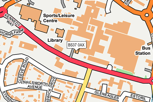
BS37 0AX is located in the Yate Central electoral ward, within the unitary authority of South Gloucestershire and the English Parliamentary constituency of Thornbury and Yate. The Sub Integrated Care Board (ICB) Location is NHS Bristol, North Somerset and South Gloucestershire ICB - 15C and the police force is Avon and Somerset. This postcode has been in use since December 2009.


GetTheData
Source: OS OpenMap – Local (Ordnance Survey)
Source: OS VectorMap District (Ordnance Survey)
Licence: Open Government Licence (requires attribution)
| Easting | 371380 |
| Northing | 182367 |
| Latitude | 51.539471 |
| Longitude | -2.414055 |
GetTheData
Source: Open Postcode Geo
Licence: Open Government Licence
| Country | England |
| Postcode District | BS37 |
| ➜ BS37 open data dashboard ➜ See where BS37 is on a map ➜ Where is Yate? | |
GetTheData
Source: Land Registry Price Paid Data
Licence: Open Government Licence
Elevation or altitude of BS37 0AX as distance above sea level:
| Metres | Feet | |
|---|---|---|
| Elevation | 80m | 262ft |
Elevation is measured from the approximate centre of the postcode, to the nearest point on an OS contour line from OS Terrain 50, which has contour spacing of ten vertical metres.
➜ How high above sea level am I? Find the elevation of your current position using your device's GPS.
GetTheData
Source: Open Postcode Elevation
Licence: Open Government Licence
| Ward | Yate Central |
| Constituency | Thornbury And Yate |
GetTheData
Source: ONS Postcode Database
Licence: Open Government Licence
| August 2023 | Violence and sexual offences | On or near The Glen | 403m |
| June 2023 | Robbery | On or near Petrol Station | 282m |
| May 2023 | Burglary | On or near The Glen | 403m |
| ➜ Get more crime data in our Crime section | |||
GetTheData
Source: data.police.uk
Licence: Open Government Licence
| Magistrates Court (Kennedy Way) | Yate | 168m |
| Wentworth (Sundridge Park) | Yate | 187m |
| Magistrates Court (Kennedy Way) | Yate | 194m |
| The White Lion (Station Road) | Yate | 247m |
| Wentworth (Sundridge Park) | Yate | 264m |
| Yate Station | 1.3km |
GetTheData
Source: NaPTAN
Licence: Open Government Licence
GetTheData
Source: ONS Postcode Database
Licence: Open Government Licence


➜ Get more ratings from the Food Standards Agency
GetTheData
Source: Food Standards Agency
Licence: FSA terms & conditions
| Last Collection | |||
|---|---|---|---|
| Location | Mon-Fri | Sat | Distance |
| Yate Post Office | 18:30 | 12:00 | 14m |
| Yate Post Office | 18:30 | 12:00 | 14m |
| Tesco East Walk | 17:30 | 11:45 | 196m |
GetTheData
Source: Dracos
Licence: Creative Commons Attribution-ShareAlike
| Facility | Distance |
|---|---|
| Anytime Fitness (Bristol Yate) East Walk, Yate, Bristol Health and Fitness Gym, Studio | 148m |
| Yate Active Lifestyle Centre Kennedy Way, Yate, Bristol Sports Hall, Indoor Bowls, Swimming Pool, Health and Fitness Gym, Studio, Squash Courts | 186m |
| Puregym (Yate) Link Road, Yate, Bristol Health and Fitness Gym | 415m |
GetTheData
Source: Active Places
Licence: Open Government Licence
| School | Phase of Education | Distance |
|---|---|---|
| Yate Academy Sundridge Park, Yate, BS37 4DX | Secondary | 329m |
| St Paul's Catholic Primary School Sundridge Park, Yate, Bristol, BS37 4EP | Primary | 429m |
| St Mary's Church of England Primary School, Yate Church Road, Yate, Bristol, BS37 5BG | Primary | 461m |
GetTheData
Source: Edubase
Licence: Open Government Licence
The below table lists the International Territorial Level (ITL) codes (formerly Nomenclature of Territorial Units for Statistics (NUTS) codes) and Local Administrative Units (LAU) codes for BS37 0AX:
| ITL 1 Code | Name |
|---|---|
| TLK | South West (England) |
| ITL 2 Code | Name |
| TLK1 | Gloucestershire, Wiltshire and Bath/Bristol area |
| ITL 3 Code | Name |
| TLK12 | Bath and North East Somerset, North Somerset and South Gloucestershire |
| LAU 1 Code | Name |
| E06000025 | South Gloucestershire |
GetTheData
Source: ONS Postcode Directory
Licence: Open Government Licence
The below table lists the Census Output Area (OA), Lower Layer Super Output Area (LSOA), and Middle Layer Super Output Area (MSOA) for BS37 0AX:
| Code | Name | |
|---|---|---|
| OA | E00075856 | |
| LSOA | E01015017 | South Gloucestershire 006D |
| MSOA | E02003095 | South Gloucestershire 006 |
GetTheData
Source: ONS Postcode Directory
Licence: Open Government Licence
| BS37 4AX | West Walk | 111m |
| BS37 4EW | Stanshawe Crescent | 134m |
| BS37 4AP | North Walk | 146m |
| BS37 4EN | Stanshawe Crescent | 169m |
| BS37 4DH | Sundridge Park | 187m |
| BS37 4DN | Stinchcombe | 197m |
| BS37 4EL | Dursley Close | 204m |
| BS37 4EJ | Painswick Drive | 217m |
| BS37 4DL | Gleneagles | 218m |
| BS37 4EB | Stanshawe Crescent | 242m |
GetTheData
Source: Open Postcode Geo; Land Registry Price Paid Data
Licence: Open Government Licence