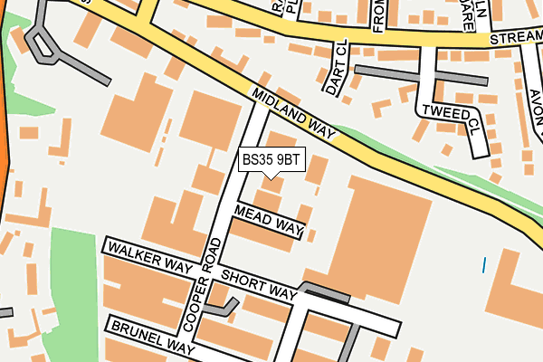
BS35 9BT is located in the Thornbury electoral ward, within the unitary authority of South Gloucestershire and the English Parliamentary constituency of Thornbury and Yate. The Sub Integrated Care Board (ICB) Location is NHS Bristol, North Somerset and South Gloucestershire ICB - 15C and the police force is Avon and Somerset. This postcode has been in use since November 2009.


GetTheData
Source: OS OpenMap – Local (Ordnance Survey)
Source: OS VectorMap District (Ordnance Survey)
Licence: Open Government Licence (requires attribution)
| Easting | 363916 |
| Northing | 189523 |
| Latitude | 51.603381 |
| Longitude | -2.522409 |
GetTheData
Source: Open Postcode Geo
Licence: Open Government Licence
| Country | England |
| Postcode District | BS35 |
| ➜ BS35 open data dashboard ➜ See where BS35 is on a map ➜ Where is Thornbury? | |
GetTheData
Source: Land Registry Price Paid Data
Licence: Open Government Licence
Elevation or altitude of BS35 9BT as distance above sea level:
| Metres | Feet | |
|---|---|---|
| Elevation | 60m | 197ft |
Elevation is measured from the approximate centre of the postcode, to the nearest point on an OS contour line from OS Terrain 50, which has contour spacing of ten vertical metres.
➜ How high above sea level am I? Find the elevation of your current position using your device's GPS.
GetTheData
Source: Open Postcode Elevation
Licence: Open Government Licence
| Ward | Thornbury |
| Constituency | Thornbury And Yate |
GetTheData
Source: ONS Postcode Database
Licence: Open Government Licence
| January 2024 | Other theft | On or near Short Way | 135m |
| January 2024 | Other theft | On or near Short Way | 135m |
| January 2024 | Public order | On or near Upper Bath Road | 293m |
| ➜ Get more crime data in our Crime section | |||
GetTheData
Source: data.police.uk
Licence: Open Government Licence
| Raglan Place (Streamleaze) | Thornbury | 167m |
| Tesco | Thornbury | 204m |
| Streamleaze Court (Rock Street) | Thornbury | 263m |
| Avon Way (Streamleaze) | Thornbury | 291m |
| Ladden Court (Avon Way) | Thornbury | 305m |
GetTheData
Source: NaPTAN
Licence: Open Government Licence
GetTheData
Source: ONS Postcode Database
Licence: Open Government Licence


➜ Get more ratings from the Food Standards Agency
GetTheData
Source: Food Standards Agency
Licence: FSA terms & conditions
| Last Collection | |||
|---|---|---|---|
| Location | Mon-Fri | Sat | Distance |
| Cooper Road | 17:30 | 11:15 | 31m |
| Streamleaze | 16:15 | 08:45 | 407m |
| High Street | 17:30 | 11:15 | 485m |
GetTheData
Source: Dracos
Licence: Creative Commons Attribution-ShareAlike
| Facility | Distance |
|---|---|
| Armstrong Hall Complex (Closed) Chapel Street, Thornbury Sports Hall, Studio | 389m |
| Elite Fitness And Leisure (Thornbury) St. Mary Street, Thornbury, Bristol Health and Fitness Gym, Studio | 418m |
| Thornbury Active Lifestyle Centre Alveston Hill, Thornbury, Bristol Sports Hall, Indoor Bowls, Swimming Pool, Health and Fitness Gym, Studio, Squash Courts | 461m |
GetTheData
Source: Active Places
Licence: Open Government Licence
| School | Phase of Education | Distance |
|---|---|---|
| Gillingstool Primary School Gillingstool, Thornbury, Bristol, BS35 2EG | Primary | 448m |
| Crossways Infant School Knapp Road, Thornbury, Bristol, BS35 2HQ | Primary | 1.1km |
| Christ The King Catholic Primary School, Thornbury Easton Hill Road, Thornbury, Bristol, BS35 1AW | Primary | 1.1km |
GetTheData
Source: Edubase
Licence: Open Government Licence
The below table lists the International Territorial Level (ITL) codes (formerly Nomenclature of Territorial Units for Statistics (NUTS) codes) and Local Administrative Units (LAU) codes for BS35 9BT:
| ITL 1 Code | Name |
|---|---|
| TLK | South West (England) |
| ITL 2 Code | Name |
| TLK1 | Gloucestershire, Wiltshire and Bath/Bristol area |
| ITL 3 Code | Name |
| TLK12 | Bath and North East Somerset, North Somerset and South Gloucestershire |
| LAU 1 Code | Name |
| E06000025 | South Gloucestershire |
GetTheData
Source: ONS Postcode Directory
Licence: Open Government Licence
The below table lists the Census Output Area (OA), Lower Layer Super Output Area (LSOA), and Middle Layer Super Output Area (MSOA) for BS35 9BT:
| Code | Name | |
|---|---|---|
| OA | E00075746 | |
| LSOA | E01014993 | South Gloucestershire 002D |
| MSOA | E02003091 | South Gloucestershire 002 |
GetTheData
Source: ONS Postcode Directory
Licence: Open Government Licence
| BS35 3UW | Cooper Road | 24m |
| BS35 3US | Walker Way | 171m |
| BS35 2BS | Midland Way | 177m |
| BS35 2BP | Streamleaze | 191m |
| BS35 3UU | Short Way | 196m |
| BS35 2BT | Raglan Place | 215m |
| BS35 3UT | Short Way | 222m |
| BS35 2BU | Frome Court | 239m |
| BS35 2BX | Streamleaze | 249m |
| BS35 2BW | Tyndale View | 258m |
GetTheData
Source: Open Postcode Geo; Land Registry Price Paid Data
Licence: Open Government Licence