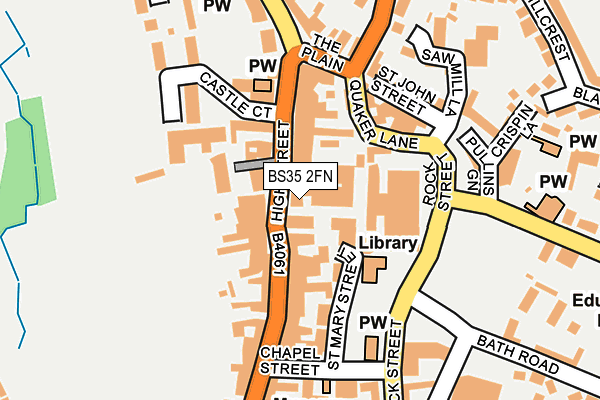
BS35 2FN is located in the Thornbury electoral ward, within the unitary authority of South Gloucestershire and the English Parliamentary constituency of Thornbury and Yate. The Sub Integrated Care Board (ICB) Location is NHS Bristol, North Somerset and South Gloucestershire ICB - 15C and the police force is Avon and Somerset. This postcode has been in use since July 2012.


GetTheData
Source: OS OpenMap – Local (Ordnance Survey)
Source: OS VectorMap District (Ordnance Survey)
Licence: Open Government Licence (requires attribution)
| Easting | 363688 |
| Northing | 190026 |
| Latitude | 51.607889 |
| Longitude | -2.525753 |
GetTheData
Source: Open Postcode Geo
Licence: Open Government Licence
| Country | England |
| Postcode District | BS35 |
| ➜ BS35 open data dashboard ➜ See where BS35 is on a map ➜ Where is Thornbury? | |
GetTheData
Source: Land Registry Price Paid Data
Licence: Open Government Licence
Elevation or altitude of BS35 2FN as distance above sea level:
| Metres | Feet | |
|---|---|---|
| Elevation | 50m | 164ft |
Elevation is measured from the approximate centre of the postcode, to the nearest point on an OS contour line from OS Terrain 50, which has contour spacing of ten vertical metres.
➜ How high above sea level am I? Find the elevation of your current position using your device's GPS.
GetTheData
Source: Open Postcode Elevation
Licence: Open Government Licence
| Ward | Thornbury |
| Constituency | Thornbury And Yate |
GetTheData
Source: ONS Postcode Database
Licence: Open Government Licence
| January 2024 | Public order | On or near Upper Bath Road | 260m |
| January 2024 | Violence and sexual offences | On or near Upper Bath Road | 260m |
| January 2024 | Public order | On or near Upper Bath Road | 260m |
| ➜ Get more crime data in our Crime section | |||
GetTheData
Source: data.police.uk
Licence: Open Government Licence
| The Plain (High Street) | Thornbury | 111m |
| Rock Street | Thornbury | 135m |
| Chapel Street (High Street) | Thornbury | 191m |
| Streamleaze Court (Rock Street) | Thornbury | 292m |
| Buckingham Parade | Thornbury | 300m |
GetTheData
Source: NaPTAN
Licence: Open Government Licence
GetTheData
Source: ONS Postcode Database
Licence: Open Government Licence


➜ Get more ratings from the Food Standards Agency
GetTheData
Source: Food Standards Agency
Licence: FSA terms & conditions
| Last Collection | |||
|---|---|---|---|
| Location | Mon-Fri | Sat | Distance |
| High Street | 17:30 | 11:15 | 86m |
| Thornbury Post Office | 17:30 | 11:15 | 95m |
| Thornbury Post Office | 17:30 | 11:15 | 95m |
GetTheData
Source: Dracos
Licence: Creative Commons Attribution-ShareAlike
| Facility | Distance |
|---|---|
| Elite Fitness And Leisure (Thornbury) St. Mary Street, Thornbury, Bristol Health and Fitness Gym, Studio | 144m |
| Armstrong Hall Complex (Closed) Chapel Street, Thornbury Sports Hall, Studio | 182m |
| Mundy Playing Fields Kington Lane, Thornbury Grass Pitches, Outdoor Tennis Courts | 355m |
GetTheData
Source: Active Places
Licence: Open Government Licence
| School | Phase of Education | Distance |
|---|---|---|
| Gillingstool Primary School Gillingstool, Thornbury, Bristol, BS35 2EG | Primary | 275m |
| St Mary's Church of England Primary School, Thornbury Church Road, Thornbury, Bristol, BS35 1HJ | Primary | 584m |
| The Castle School Park Road, Thornbury, Bristol, BS35 1HT | Secondary | 845m |
GetTheData
Source: Edubase
Licence: Open Government Licence
The below table lists the International Territorial Level (ITL) codes (formerly Nomenclature of Territorial Units for Statistics (NUTS) codes) and Local Administrative Units (LAU) codes for BS35 2FN:
| ITL 1 Code | Name |
|---|---|
| TLK | South West (England) |
| ITL 2 Code | Name |
| TLK1 | Gloucestershire, Wiltshire and Bath/Bristol area |
| ITL 3 Code | Name |
| TLK12 | Bath and North East Somerset, North Somerset and South Gloucestershire |
| LAU 1 Code | Name |
| E06000025 | South Gloucestershire |
GetTheData
Source: ONS Postcode Directory
Licence: Open Government Licence
The below table lists the Census Output Area (OA), Lower Layer Super Output Area (LSOA), and Middle Layer Super Output Area (MSOA) for BS35 2FN:
| Code | Name | |
|---|---|---|
| OA | E00075739 | |
| LSOA | E01014991 | South Gloucestershire 002B |
| MSOA | E02003091 | South Gloucestershire 002 |
GetTheData
Source: ONS Postcode Directory
Licence: Open Government Licence
| BS35 2AR | High Street | 41m |
| BS35 2AH | High Street | 58m |
| BS35 2AQ | High Street | 61m |
| BS35 2AB | St Mary Street | 73m |
| BS35 2AJ | High Street | 83m |
| BS35 2AZ | Horseshoe Lane | 89m |
| BS35 2AD | Quaker Lane | 103m |
| BS35 2AL | The Close | 122m |
| BS35 2AP | High Street | 137m |
| BS35 2AG | The Plain | 154m |
GetTheData
Source: Open Postcode Geo; Land Registry Price Paid Data
Licence: Open Government Licence