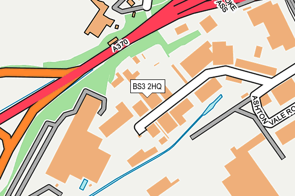
BS3 2HQ is located in the Bedminster electoral ward, within the unitary authority of Bristol, City of and the English Parliamentary constituency of Bristol South. The Sub Integrated Care Board (ICB) Location is NHS Bristol, North Somerset and South Gloucestershire ICB - 15C and the police force is Avon and Somerset. This postcode has been in use since June 1981.


GetTheData
Source: OS OpenMap – Local (Ordnance Survey)
Source: OS VectorMap District (Ordnance Survey)
Licence: Open Government Licence (requires attribution)
| Easting | 356379 |
| Northing | 171270 |
| Latitude | 51.438733 |
| Longitude | -2.628965 |
GetTheData
Source: Open Postcode Geo
Licence: Open Government Licence
| Country | England |
| Postcode District | BS3 |
| ➜ BS3 open data dashboard ➜ See where BS3 is on a map ➜ Where is Bristol? | |
GetTheData
Source: Land Registry Price Paid Data
Licence: Open Government Licence
Elevation or altitude of BS3 2HQ as distance above sea level:
| Metres | Feet | |
|---|---|---|
| Elevation | 10m | 33ft |
Elevation is measured from the approximate centre of the postcode, to the nearest point on an OS contour line from OS Terrain 50, which has contour spacing of ten vertical metres.
➜ How high above sea level am I? Find the elevation of your current position using your device's GPS.
GetTheData
Source: Open Postcode Elevation
Licence: Open Government Licence
| Ward | Bedminster |
| Constituency | Bristol South |
GetTheData
Source: ONS Postcode Database
Licence: Open Government Licence
| June 2022 | Criminal damage and arson | On or near Shopping Area | 44m |
| June 2022 | Violence and sexual offences | On or near Ashton Road | 121m |
| June 2022 | Drugs | On or near Ashton Road | 121m |
| ➜ Get more crime data in our Crime section | |||
GetTheData
Source: data.police.uk
Licence: Open Government Licence
| Ashton Park School | Bower Ashton | 192m |
| Winterstoke Road | Bower Ashton | 334m |
| Blackmoors Lane (Clanage Road) | Bower Ashton | 346m |
| The Ashton | Ashton Court Estate | 468m |
| Bower Ashton Campus | Bower Ashton | 530m |
| Parson Street Station | 1.6km |
| Bedminster Station | 2.4km |
| Clifton Down Station | 3.1km |
GetTheData
Source: NaPTAN
Licence: Open Government Licence
Estimated total energy consumption in BS3 2HQ by fuel type, 2015.
| Consumption (kWh) | 219,830 |
|---|---|
| Meter count | 7 |
| Mean (kWh/meter) | 31,404 |
| Median (kWh/meter) | 34,230 |
GetTheData
Source: Postcode level gas estimates: 2015 (experimental)
Source: Postcode level electricity estimates: 2015 (experimental)
Licence: Open Government Licence
GetTheData
Source: ONS Postcode Database
Licence: Open Government Licence


➜ Get more ratings from the Food Standards Agency
GetTheData
Source: Food Standards Agency
Licence: FSA terms & conditions
| Last Collection | |||
|---|---|---|---|
| Location | Mon-Fri | Sat | Distance |
| Marsh Road | 16:30 | 11:30 | 406m |
| Parklands Road / Bower Ashton | 17:00 | 11:00 | 407m |
| Ashton Park | 17:00 | 12:30 | 703m |
GetTheData
Source: Dracos
Licence: Creative Commons Attribution-ShareAlike
| Facility | Distance |
|---|---|
| David Lloyd (Bristol Long Ashton) Ashton Road, Bristol Sports Hall, Swimming Pool, Health and Fitness Gym, Indoor Tennis Centre, Studio, Squash Courts, Outdoor Tennis Courts | 181m |
| Ashton Park Sports Centre Blackmoors Lane, Bristol Health and Fitness Gym, Grass Pitches, Sports Hall, Studio, Artificial Grass Pitch | 230m |
| The Clanage Clanage Road, Bristol Grass Pitches | 554m |
GetTheData
Source: Active Places
Licence: Open Government Licence
| School | Phase of Education | Distance |
|---|---|---|
| Ashton Park School Blackmoor's Lane, Bower Ashton, Bristol, BS3 2JL | Secondary | 203m |
| Ashton Vale Primary School Avebury Road, Ashton Vale, Bristol, BS3 2QG | Primary | 562m |
| Ashton Gate Primary School Ashton Gate Road, Bristol, BS3 1SZ | Primary | 1.1km |
GetTheData
Source: Edubase
Licence: Open Government Licence
The below table lists the International Territorial Level (ITL) codes (formerly Nomenclature of Territorial Units for Statistics (NUTS) codes) and Local Administrative Units (LAU) codes for BS3 2HQ:
| ITL 1 Code | Name |
|---|---|
| TLK | South West (England) |
| ITL 2 Code | Name |
| TLK1 | Gloucestershire, Wiltshire and Bath/Bristol area |
| ITL 3 Code | Name |
| TLK11 | Bristol, City of |
| LAU 1 Code | Name |
| E06000023 | Bristol, City of |
GetTheData
Source: ONS Postcode Directory
Licence: Open Government Licence
The below table lists the Census Output Area (OA), Lower Layer Super Output Area (LSOA), and Middle Layer Super Output Area (MSOA) for BS3 2HQ:
| Code | Name | |
|---|---|---|
| OA | E00073253 | |
| LSOA | E01014501 | Bristol 041A |
| MSOA | E02003052 | Bristol 041 |
GetTheData
Source: ONS Postcode Directory
Licence: Open Government Licence
| BS3 2JH | Ashton Road | 152m |
| BS3 2JJ | Blackmoors Lane | 263m |
| BS3 2JN | Rownham Close | 301m |
| BS3 2JW | Parklands Road | 376m |
| BS3 2NA | Marsh Road | 403m |
| BS3 2JP | Parklands Road | 411m |
| BS3 2JR | Parklands Road | 424m |
| BS3 2JS | Courtlands Lane | 446m |
| BS3 2LE | Bower Ashton Terrace | 476m |
| BS3 2JT | Kennel Lodge Road | 513m |
GetTheData
Source: Open Postcode Geo; Land Registry Price Paid Data
Licence: Open Government Licence